Category: Emergency / Disaster Management

  • Smart Incident Management: How Technology Improves Emergency Response

    Smart Incident Management: How Technology Improves Emergency Response

    In emergency situations, time is everything. Whether it’s a natural disaster, fire outbreak, public safety threat, industrial accident, or infrastructure failure, the speed and effectiveness of response can determine the difference between controlled damage and catastrophic loss. Traditionally, incident management relied heavily on manual coordination, fragmented communication, and delayed decision-making. Emergency teams often worked with incomplete information, limited visibility, and disconnected systems.

    Today, however, technology is transforming how organizations detect, manage, and respond to incidents. From real-time data monitoring and automated alerts to predictive analytics and GIS-based coordination, smart incident management systems are enabling faster, more accurate, and more coordinated emergency response.

    This blog explores how modern technology is reshaping incident management and why organizations must adopt smarter systems to improve operational resilience and public safety.

    What Is Smart Incident Management?

    Smart incident management refers to the use of digital technologies to detect, analyze, respond to, and resolve incidents efficiently. It integrates data, communication systems, automation, and analytics into a centralized framework that helps organizations respond quickly and make informed decisions during critical situations.

    Unlike traditional response models, smart incident management focuses on:

    • Real-time situational awareness

    • Automated incident detection and alerts

    • Centralized command and coordination

    • Data-driven decision-making

    • Faster resolution and recovery

    The goal is not just reacting to incidents, but anticipating risks and minimizing impact.

    Why Traditional Incident Response Falls Short

    Many organizations still rely on legacy processes that create delays and confusion during emergencies. These systems typically suffer from:

    • Lack of real-time visibility into incidents

    • Manual communication between teams

    • Disconnected data sources

    • Slow escalation procedures

    • Limited coordination across departments

    As operations become more digital and complex, these limitations increase operational risk. Modern organizations require intelligent systems that support proactive response rather than reactive firefighting.

    Key Technologies Powering Smart Incident Management

    1. Real-Time Monitoring and IoT Sensors

    IoT devices and sensors continuously monitor infrastructure, facilities, and operational environments. These devices detect anomalies such as equipment failure, temperature changes, smoke, or unauthorized access.

    For example, smart sensors in industrial plants can detect pressure irregularities before a major failure occurs, allowing teams to intervene early.

    Real-time monitoring provides:

    • Immediate detection of incidents

    • Continuous operational visibility

    • Automated alerts to response teams

    • Reduced dependency on manual reporting

    This early detection capability significantly reduces response time.

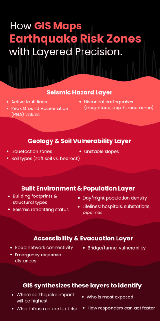
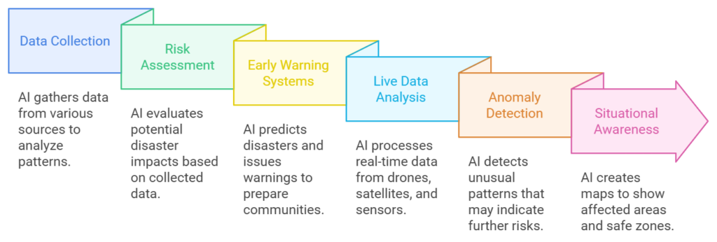
    2. Geographic Information Systems (GIS) for Situational Awareness

    GIS technology plays a crucial role in emergency response by providing location-based intelligence. It helps responders visualize incidents geographically and coordinate resources more effectively.

    GIS enables teams to:

    • Map incident locations in real time

    • Identify affected zones and risk areas

    • Track emergency vehicles and field teams

    • Plan evacuation routes

    • Allocate resources efficiently

    By combining spatial data with operational insights, GIS improves response coordination and decision-making.

    3. AI and Predictive Analytics for Risk Prevention

    Artificial intelligence is transforming incident management by identifying patterns and predicting potential risks before they escalate.

    AI systems analyze historical data, system behavior, and environmental factors to detect warning signals. This helps organizations move from reactive response to proactive prevention.

    Predictive capabilities include:

    • Identifying high-risk locations or operations

    • Forecasting equipment failures

    • Detecting suspicious activities or anomalies

    • Predicting service disruptions

    The ability to anticipate incidents improves preparedness and reduces operational downtime.

    4. Automated Alert and Notification Systems

    During emergencies, communication delays can cause serious consequences. Automated notification systems ensure the right people receive the right information instantly.

    These systems enable:

    • Instant alerts to relevant teams

    • Automated escalation procedures

    • Multi-channel communication (SMS, email, dashboards)

    • Standardized response workflows

    Automation removes communication bottlenecks and ensures consistent response processes.

    5. Centralized Command and Control Platforms

    A centralized command center integrates data from multiple systems into a single interface. This provides decision-makers with a complete operational view.

    Key benefits include:

    • Unified incident tracking

    • Real-time performance monitoring

    • Cross-department coordination

    • Faster decision-making

    • Improved accountability

    Centralized control ensures all stakeholders operate with the same information.

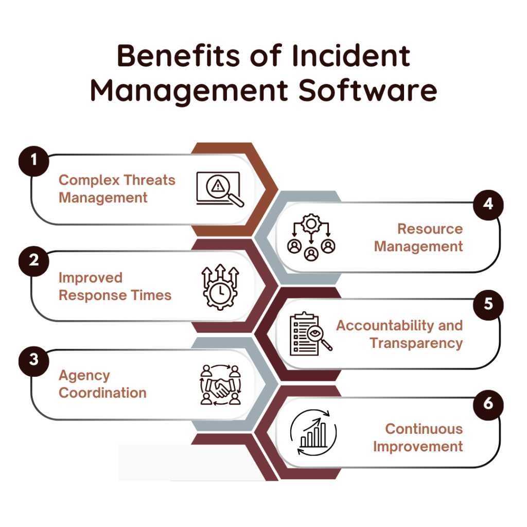
    How Smart Incident Management Improves Emergency Response

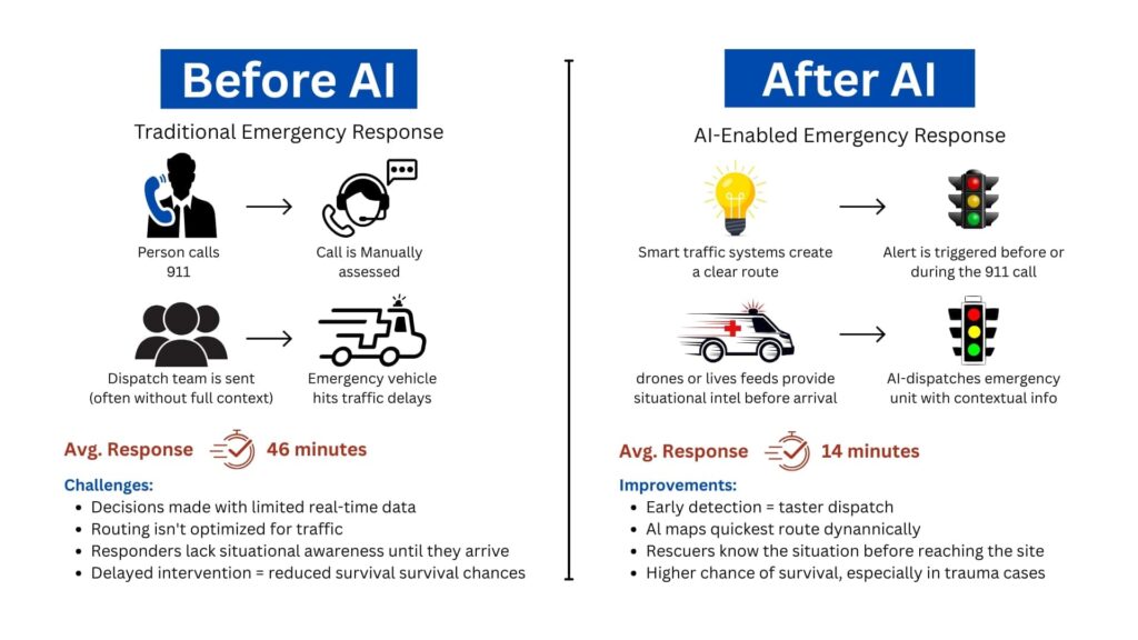
    Faster Response Time: Automated detection and alerts eliminate delays in identifying incidents. Response teams receive immediate information and act quickly.

    Better Decision-Making: Access to real-time data and analytics enables leadership teams to make informed decisions under pressure.

    Improved Coordination Across Teams: Integrated communication systems reduce confusion and ensure seamless collaboration between departments and field teams.

    Reduced Operational Risk: Predictive analytics and proactive monitoring help prevent incidents before they occur.

    Enhanced Public and Workplace Safety: Faster response and better coordination minimize damage and protect lives.

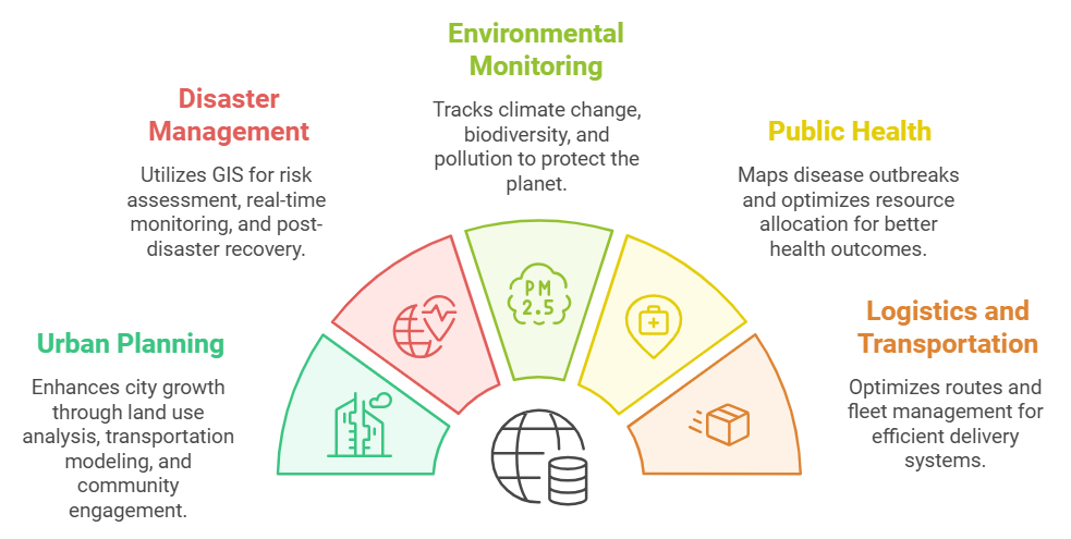
    Industry Applications of Smart Incident Management

    Smart incident management systems are widely used across industries where safety and operational continuity are critical.

    Common applications include:

    • Smart Cities: Emergency response coordination, disaster management, traffic incident handling

    • Manufacturing: Equipment failure detection, workplace safety monitoring

    • Healthcare: Emergency patient response systems, facility management

    • Energy and Utilities: Infrastructure monitoring, outage management

    • Transportation and Logistics: Fleet tracking, accident response

    • IT and Digital Services: Service outage and cybersecurity incident management

    These applications demonstrate the broad impact of intelligent response systems across sectors.

    Best Practices for Implementing Smart Incident Management

    Organizations adopting smart incident management should follow a structured approach to ensure success.

    Recommended practices include:

    • Establish a centralized incident response framework

    • Integrate monitoring and communication systems

    • Automate alert and escalation workflows

    • Train teams on response protocols

    • Use analytics to continuously improve processes

    • Ensure data security and compliance

    A well-planned implementation improves efficiency and maximizes long-term benefits.

    The Role of Technology Partners in Incident Management Transformation

    Implementing advanced incident management systems requires technical expertise, integration capabilities, and strategic planning. Many organizations choose to work with specialized technology providers to accelerate deployment and reduce complexity. Technology partners help design scalable architectures, integrate systems, and ensure reliable performance under critical conditions. Organizations like SCS Tech India support enterprises in building intelligent incident management frameworks by combining data analytics, GIS, automation, and digital infrastructure to strengthen operational resilience.

    Conclusion: From Reactive Response to Intelligent Preparedness

    The future of incident management is proactive, data-driven, and highly automated. Organizations that adopt smart incident management systems gain faster response capabilities, better operational control, and stronger resilience against disruptions. As digital ecosystems grow more complex and risks become more unpredictable, relying on traditional response methods is no longer sufficient. Technology now enables organizations to detect incidents earlier, respond faster, and recover more efficiently.

    For businesses and public organizations alike, smart incident management is not just a technological upgrade—it is a strategic investment in safety, continuity, and long-term sustainability.

  • Using GIS Mapping to Identify High-Risk Zones for Earthquake Preparedness

    Using GIS Mapping to Identify High-Risk Zones for Earthquake Preparedness

    GIS mapping combines seismicity, ground conditions, building exposure, and evacuation routes into multi-layer, spatial models. This gives a clear, specific image of where the greatest dangers are — a critical function in disaster response software designed for earthquake preparedness.

    Using this information, planners and emergency responders can target resources, enhance infrastructure strength, and create effective evacuation plans individualized for the zones that require it most.

    In this article, we dissect how GIS maps pinpoint high-risk earthquake areas and why this spatial accuracy is critical to constructing wiser, life-saving readiness plans.

    Why GIS Mapping Matters for Earthquake Preparedness?

    When it comes to earthquake resilience, geography isn’t just a consideration — it’s the whole basis of risk. The key to minimal disruption versus disaster is where the infrastructure is located, how the land responds when stressed, and what populations are in the path.

    That’s where GIS mapping steps in — not as a passive data tool, but as a central decision engine for risk identification and GIS and disaster management planning.

    Here’s why GIS is indispensable:

    • Earthquake risk is spatially uneven. Some zones rest directly above active fault lines, others lie on liquefiable soil, and many are in structurally vulnerable urban cores. GIS doesn’t generalize — it pinpoints. It visualizes how these spatial variables overlap and create compounded risks.
    • Preparedness needs layered visibility. Risk isn’t just about tectonics. It’s about how seismic energy interacts with local geology, critical infrastructure, and human activity. GIS allows planners to stack these variables — seismic zones, building footprints, population density, utility lines — to get a granular, real-time understanding of risk concentration.
    • Speed of action depends on the clarity of data. During a crisis, knowing which areas will be hit hardest, which routes are most likely to collapse, and which neighborhoods lack structural resilience is non-negotiable. GIS systems provide this insight before the event, enabling governments and agencies to act, not react.

    GIS isn’t just about making maps look smarter. It’s about building location-aware strategies that can protect lives, infrastructure, and recovery timelines.

    Without GIS, preparedness is built on assumptions. With it, it’s built on precision.

    How GIS Identifies High-Risk Earthquake Zones

    How GIS Maps Earthquake Risk Zones with Layered Precision

    Not all areas within an earthquake-prone region carry the same level of risk. Some neighborhoods are built on solid bedrock. Others sit on unstable alluvium or reclaimed land that could amplify ground shaking or liquefy under stress. What differentiates a moderate event from a mass-casualty disaster often lies in these invisible geographic details.

    Here’s how it works in operational terms:

    1. Layering Historical Seismic and Fault Line Data

    GIS platforms integrate high-resolution datasets from geological agencies (like USGS or national seismic networks) to visualize:

    • The proximity of assets to fault lines
    • Historical earthquake occurrences — including magnitude, frequency, and depth
    • Seismic zoning maps based on recorded ground motion patterns

    This helps planners understand not just where quakes happen, but where energy release is concentrated and where recurrence is likely.

    2. Analyzing Geology and Soil Vulnerability

    Soil type plays a defining role in earthquake impact. GIS systems pull in geoengineering layers that include:

    • Soil liquefaction susceptibility
    • Slope instability and landslide zones
    • Water table depth and moisture retention capacity

    By combining this with surface elevation models, GIS reveals which areas are prone to ground failure, wave amplification, or surface rupture — even if those zones are outside the epicenter region.

    3. Overlaying Built Environment and Population Exposure

    High-risk zones aren’t just geological — they’re human. GIS integrates urban planning data such as:

    • Building density and structural typology (e.g., unreinforced masonry, high-rise concrete)
    • Age of construction and seismic retrofitting status
    • Population density during day/night cycles
    • Proximity to lifelines like hospitals, power substations, and water pipelines

    These layers turn raw hazard maps into impact forecasts, pinpointing which blocks, neighborhoods, or industrial zones are most vulnerable — and why.

    4. Modeling Accessibility and Emergency Constraints

    Preparedness isn’t just about who’s at risk — it’s also about how fast they can be reached. GIS models simulate:

    • Evacuation route viability based on terrain and road networks
    • Distance from emergency response centers
    • Infrastructure interdependencies — e.g., if one bridge collapses, what neighborhoods become unreachable?

    GIS doesn’t just highlight where an earthquake might hit — it shows where it will hurt the most, why it will happen there, and what stands to be lost. That’s the difference between reacting with limited insight and planning with high precision.

    Key GIS Data Inputs That Influence Risk Mapping

    Accurate identification of earthquake risk zones depends on the quality, variety, and granularity of the data fed into a GIS platform. Different datasets capture unique risk factors, and when combined, they paint a comprehensive picture of hazard and vulnerability.

    Let’s break down the essential GIS inputs that drive earthquake risk mapping:

    1. Seismic Hazard Data

    This includes:

    • Fault line maps with exact coordinates and fault rupture lengths
    • Historical earthquake catalogs detailing magnitude (M), depth (km), and frequency
    • Peak Ground Acceleration (PGA) values: A critical metric used to estimate expected shaking intensity, usually expressed as a fraction of gravitational acceleration (g). For example, a PGA of 0.4g indicates ground shaking with 40% of Earth’s gravity force — enough to cause severe structural damage.

    GIS integrates these datasets to create probabilistic seismic hazard maps. These maps often express risk in terms of expected ground shaking exceedance within a given return period (e.g., 10% probability of exceedance in 50 years).

    2. Soil and Geotechnical Data

    Soil composition and properties modulate seismic wave behavior:

    • Soil type classification (e.g., rock, stiff soil, soft soil) impacts the amplification of seismic waves. Soft soils can increase shaking intensity by up to 2-3 times compared to bedrock.
    • Liquefaction susceptibility indexes quantify the likelihood that saturated soils will temporarily lose strength, turning solid ground into a fluid-like state. This risk is highest in loose sandy soils with shallow water tables.
    • Slope and landslide risk models identify areas where shaking may trigger secondary hazards such as landslides, compounding damage.

    GIS uses Digital Elevation Models (DEM) and borehole data to spatially represent these factors. Combining these with seismic data highlights zones where ground failure risks can triple expected damage.

    3. Built Environment and Infrastructure Datasets

    Structural vulnerability is central to risk:

    • Building footprint databases detail the location, size, and construction material of each structure. For example, unreinforced masonry buildings have failure rates up to 70% at moderate shaking intensities (PGA 0.3-0.5g).
    • Critical infrastructure mapping covers hospitals, fire stations, water treatment plants, power substations, and transportation hubs. Disruption in these can multiply casualties and prolong recovery.
    • Population density layers often leverage census data and real-time mobile location data to model daytime and nighttime occupancy variations. Urban centers may see population densities exceeding 10,000 people per square kilometer, vastly increasing exposure.

    These datasets feed into risk exposure models, allowing GIS to calculate probable damage, casualties, and infrastructure downtime.

    4. Emergency Access and Evacuation Routes

    GIS models simulate accessibility and evacuation scenarios by analyzing:

    • Road network connectivity and capacity
    • Bridges and tunnels’ structural health and vulnerability
    • Alternative routing options in case of blocked pathways

    By integrating these diverse datasets, GIS creates a multi-dimensional risk profile that doesn’t just map hazard zones, but quantifies expected impact with numerical precision. This drives data-backed preparedness rather than guesswork.

    Conclusion 

    By integrating seismic hazard patterns, soil conditions, urban vulnerability, and emergency logistics, GIS equips utility firms, government agencies, and planners with the tools to anticipate failures before they happen and act decisively to protect communities, exactly the purpose of advanced methods to predict natural disasters and robust disaster response software.

    For organizations committed to leveraging cutting-edge technology to enhance disaster resilience, SCSTech offers tailored GIS solutions that integrate complex data layers into clear, operational risk maps. Our expertise ensures your earthquake preparedness plans are powered by precision, making smart, data-driven decisions the foundation of your risk management strategy.

  • 5 Ways Digital Twin Technology is Helping Utility Firms Predict and Prevent Failures

    5 Ways Digital Twin Technology is Helping Utility Firms Predict and Prevent Failures

    Utility companies encounter expensive equipment breakdowns that halt service and compromise safety. The greatest challenge is not repairing breakdowns, it’s predicting when they will occur.

    As part of a broader digital transformation strategy, digital twin tech produces virtual, real-time copies of physical assets, fueled by real-time sensor feeds such as temperature, vibration, and load. This dynamic model replicates asset health in real-time as it evolves.

    Utilities identify early warning signs, model stress conditions, and predict failure horizons with digital twins. Maintenance becomes a proactive intervention in response to real conditions instead of reactive repairs.

    The Digital Twin Technology Role in Failure Prediction 

    How Digital Twins work in Utility Systems

    Utility firms run on tight margins for error. A single equipment failure — whether it’s in a substation, water main, or gas line — can trigger costly downtimes, safety risks, and public backlash. The problem isn’t just failure. It’s not knowing when something is about to fail.

    Digital twin technology changes that.

    At its core, a digital twin is a virtual replica of a physical asset or system. But this isn’t just a static model. It’s a dynamic, real-time environment fed by live data from the field.

    • Sensors on physical assets capture metrics like:
      • Temperature
      • Pressure
      • Vibration levels
      • Load fluctuations
    • That data streams into the digital twin, which updates in real time and mirrors the condition of the asset as it evolves.

    This real-time reflection isn’t just about monitoring — it’s about prediction. With enough data history, utility firms can start to:

    • Detect anomalies before alarms go off
    • Simulate how an asset might respond under stress (like heatwaves or load spikes)
    • Forecast the likely time to failure based on wear patterns

    As a result, maintenance shifts from reactive to proactive. You’re no longer waiting for equipment to break or relying on calendar-based checkups. Instead:

    • Assets are serviced based on real-time health
    • Failures are anticipated — and often prevented
    • Resources are allocated based on actual risk, not guesswork

    In high-stakes systems where uptime matters, this shift isn’t just an upgrade — it’s a necessity.

    Ways Digital Twin Technology is Helping Utility Firms Predict and Prevent Failures

    1. Proactive Maintenance Through Real-Time Monitoring

    In a typical utility setup, maintenance is either time-based (like changing oil every 6 months) or event-driven (something breaks, then it gets fixed). Neither approach adapts to how the asset is actually performing.

    Digital twins allow firms to move to condition-based maintenance, using real-time data to catch failure indicators before anything breaks. This shift is a key component of any effective digital transformation strategy that utility firms implement to improve asset management.

    Take this scenario:

    • A substation transformer is fitted with sensors tracking internal oil temperature, moisture levels, and load current.
    • The digital twin uses this live stream to detect subtle trends, like a slow rise in dissolved gas levels, which often points to early insulation breakdown.
    • Based on this insight, engineers know the transformer doesn’t need immediate replacement, but it does need inspection within the next two weeks to prevent cascading failure.

    That level of specificity is what sets digital twins apart from basic SCADA systems.

    Other real-world examples include:

    • Water utilities detecting flow inconsistencies that indicate pipe leakage, before it becomes visible or floods a zone.
    • Wind turbine operators identifying torque fluctuations in gearboxes that predict mechanical fatigue.

    Here’s what this proactive monitoring unlocks:

    • Early detection of failure patterns — long before traditional alarms would trigger.
    • Targeted interventions — send teams to fix assets showing real degradation, not just based on the calendar.
    • Shorter repair windows — because issues are caught earlier and are less severe.
    • Smarter budget use — fewer emergency repairs and lower asset replacement costs.

    This isn’t just monitoring for the sake of data. It’s a way to read the early signals of failure — and act on them before the problem exists in the real world.

    2. Enhanced Vegetation Management and Risk Mitigation

    Vegetation encroachment is a leading cause of power outages and wildfire risks. Traditional inspection methods are often time-consuming and less precise. Digital twins, integrated with LiDAR and AI technologies, offer a more efficient solution. By creating detailed 3D models of utility networks and surrounding vegetation, utilities can predict growth patterns and identify high-risk areas.

    This enables utility firms to:

    • Map the exact proximity of vegetation to assets in real-time
    • Predict growth patterns based on species type, local weather, and terrain
    • Pinpoint high-risk zones before branches become threats or trigger regulatory violations

    Let’s take a real-world example:

    Southern California Edison used Neara’s digital twin platform to overhaul its vegetation management.

    • What used to take months to determine clearance guidance now takes weeks
    • Work execution was completed 50% faster, thanks to precise, data-backed targeting

    Vegetation isn’t going to stop growing. But with a digital twin watching over it, utility firms don’t have to be caught off guard.

    3. Optimized Grid Operations and Load Management

    Balancing supply and demand in real-time is crucial for grid stability. Digital twins facilitate this by simulating various operational scenarios, allowing utilities to optimize energy distribution and manage loads effectively. By analyzing data from smart meters, sensors, and other grid components, potential bottlenecks can be identified and addressed proactively.

    Here’s how it works in practice:

    • Data from smart meters, IoT sensors, and control systems is funnelled into the digital twin.
    • The platform then runs what-if scenarios:
      • What happens if demand spikes in one region?
      • What if a substation goes offline unexpectedly?
      • How do EV charging surges affect residential loads?

    These simulations allow utility firms to:

    • Balance loads dynamically — shifting supply across regions based on actual demand
    • Identify bottlenecks in the grid — before they lead to voltage drops or system trips
    • Test responses to outages or disruptions — without touching the real infrastructure

    One real-world application comes from Siemens, which uses digital twin technology to model substations across its power grid. By creating these virtual replicas, operators can:

    • Detect voltage anomalies or reactive power imbalances quickly
    • Simulate switching operations before pushing them live
    • Reduce fault response time and improve grid reliability overall

    This level of foresight turns grid management from a reactive firefighting role into a strategic, scenario-tested process.

    When energy systems are stretched thin, especially with renewables feeding intermittent loads, a digital twin becomes less of a luxury and more of a grid operator’s control room essential.

    4. Improved Emergency Response and Disaster Preparedness

    When a storm hits, a wildfire spreads, or a substation goes offline unexpectedly, every second counts. Utility firms need more than just a damage report — they need situational awareness and clear action paths.

    Digital twins give operators that clarity, before, during, and after an emergency.

    Unlike traditional models that provide static views, digital twins offer live, geospatially aware environments that evolve in real time based on field inputs. This enables faster, better-coordinated responses across teams.

    Here’s how digital twins strengthen emergency preparedness:

    • Pre-event scenario planning
      • Simulate storm surges, fire paths, or equipment failure to see how the grid will respond
      • Identify weak links in the network (e.g. aging transformers, high-risk lines) and pre-position resources accordingly
    • Real-time situational monitoring
      • Integrate drone feeds, sensor alerts, and field crew updates directly into the twin
      • Track which areas are inaccessible, where outages are expanding, and how restoration efforts are progressing
    • Faster field deployment
      • Dispatch crews with exact asset locations, hazard maps, and work orders tied to real-time conditions
      • Reduce miscommunication and avoid wasted trips during chaotic situations

    For example, during wildfires or hurricanes, digital twins can overlay evacuation zones, line outage maps, and grid stress indicators in one place — helping both operations teams and emergency planners align fast.

    When things go wrong, digital twins don’t just help respond — they help prepare, so the fallout is minimised before it even begins.

    5. Streamlined Regulatory Compliance and Reporting

    For utility firms, compliance isn’t optional, it’s a constant demand. From safety inspections to environmental impact reports, regulators expect accurate documentation, on time, every time. Gathering that data manually is often time-consuming, error-prone, and disconnected across departments.

    Digital twins simplify the entire compliance process by turning operational data into traceable, report-ready insights.

    Here’s what that looks like in practice:

    • Automated data capture
      • Sensors feed real-time operational metrics (e.g., line loads, maintenance history, vegetation clearance) into the digital twin continuously
      • No need to chase logs, cross-check spreadsheets, or manually input field data
    • Built-in audit trails
      • Every change to the system — from a voltage dip to a completed work order — is automatically timestamped and stored
      • Auditors get clear records of what happened, when, and how the utility responded
    • On-demand compliance reports
      • Whether it’s for NERC reliability standards, wildfire mitigation plans, or energy usage disclosures, reports can be generated quickly using accurate, up-to-date data
      • No scrambling before deadlines, no gaps in documentation

    For utilities operating in highly regulated environments — especially those subject to increasing scrutiny over grid safety and climate risk — this level of operational transparency is a game-changer.

    With a digital twin in place, compliance shifts from being a back-office burden to a built-in outcome of how the grid is managed every day.

    Conclusion

    Digital twin technology is revolutionizing the utility sector by enabling predictive maintenance, optimizing operations, enhancing emergency preparedness, and ensuring regulatory compliance. By adopting this technology, utility firms can improve reliability, reduce costs, and better serve their customers in an increasingly complex and demanding environment.

    At SCS Tech, we specialize in delivering comprehensive digital transformation solutions tailored to the unique needs of utility companies. Our expertise in developing and implementing digital twin strategies ensures that your organization stays ahead of the curve, embracing innovation to achieve operational excellence.

    Ready to transform your utility operations with proven digital utility solutions? Contact one of the leading digital transformation companies—SCS Tech—to explore how our tailored digital transformation strategy can help you predict and prevent failures.

  • How Real-Time Data and AI are Revolutionizing Emergency Response?

    How Real-Time Data and AI are Revolutionizing Emergency Response?

    Imagine this: you’re stuck in traffic when suddenly, an ambulance appears in your rearview mirror. The siren’s blaring. You want to move—but the road is jammed. Every second counts. Lives are at stake.

    Now imagine this: what if AI could clear a path for that ambulance before it even gets close to you?

    Sounds futuristic? Not anymore.

    A city in California recently cut ambulance response times from 46 minutes to just 14 minutes using real-time traffic management powered by AI. That’s 32 minutes shaved off—minutes that could mean the difference between life and death.

    That’s the power of real-time data and AI in emergency response.

    And it’s not just about traffic. From predicting wildfires to automating 911 dispatches and identifying survivors in collapsed buildings—AI is quietly becoming the fastest responder we have. These innovations also highlight advanced methods to predict natural disasters long before they escalate.

    So the real question is:

    Are you ready to understand how tech is reshaping the way we handle emergencies—and how your organization can benefit?

    Let’s dive in.

    The Problem With Traditional Emergency Response

    Let’s not sugarcoat it—our emergency response systems were never built for speed or precision. They were designed in an era when landlines were the only lifeline and responders relied on intuition more than information.

    Even today, the process often follows this outdated chain:

    A call comes in → Dispatch makes judgment calls → Teams are deployed → Assessment happens on site.

    Before Before and After AI

    Here’s why that model is collapsing under pressure:

    1. Delayed Decision-Making in a High-Stakes Window

    Every emergency has a golden hour—a short window when intervention can dramatically increase survival rates. According to a study published in BMJ Open, a delay of even 5 minutes in ambulance arrival is associated with a 10% decrease in survival rate in cases like cardiac arrest or major trauma.

    But that’s what’s happening—because the system depends on humans making snap decisions with incomplete or outdated information. And while responders are trained, they’re not clairvoyants.

    2. One Size Fits None: Poor Resource Allocation

    A report by McKinsey & Company found that over 20% of emergency deployments in urban areas were either over-responded or under-resourced, often due to dispatchers lacking real-time visibility into resource availability or incident severity.

    That’s not just inefficient—it’s dangerous.

    3. Siloed Systems = Slower Reactions

    Police, fire, EMS—even weather and utility teams—operate on different digital platforms. In a disaster, that means manual handoffs, missed updates, or even duplicate efforts.

    And in events like hurricanes, chemical spills, or industrial fires, inter-agency coordination isn’t optional—it’s survival.

    A case study from Houston’s response to Hurricane Harvey found that agencies using interoperable data-sharing platforms responded 40% faster than those using siloed systems.

    Real-Time Data and AI: Your Digital First Responders

    Now imagine a different model—one that doesn’t wait for a call. One that acts the moment data shows a red flag.

    We’re talking about real-time data, gathered from dozens of touchpoints across your environment—and processed instantly by AI systems.

    But before we dive into what AI does, let’s first understand where this data comes from.

    Traditional data systems tell you what just happened.

    Predictive analytics powered by AI tells you what’s about to happen, offering reliable methods to predict natural disasters in real-time.

    And that gives responders something they’ve never had before: lead time.

    Let’s break it down:

    • Machine learning models, trained on thousands of past incidents, can identify the early signs of a wildfire before a human even notices smoke.
    • In flood-prone cities, predictive AI now uses rainfall, soil absorption, and river flow data to estimate overflow risks hours in advance. Such forecasting techniques are among the most effective methods to predict natural disasters like flash floods and landslides.
    • Some 911 centers now use natural language processing to analyze caller voice patterns, tone, and choice of words to detect hidden signs of a heart attack or panic disorder—often before the patient is even aware.

    What Exactly Is AI Doing in Emergencies?

    Think of AI as your 24/7 digital analyst that never sleeps. It does the hard work behind the scenes—sorting through mountains of data to find the one insight that saves lives.

    Here’s how AI is helping:

    • Spotting patterns before humans can: Whether it’s the early signs of a wildfire or crowd movement indicating a possible riot, AI detects red flags fast.
    • Predicting disasters: With enough historical and environmental data, AI applies advanced methods to predict natural disasters such as floods, earthquakes, and infrastructure collapse.
    • Understanding voice and language: Natural Language Processing (NLP) helps AI interpret 911 calls, tweets, and distress messages in real time—even identifying keywords like “gunshot,” “collapsed,” or “help.”
    • Interpreting images and video: Computer vision lets drones and cameras analyze real-time visuals—detecting injuries, structural damage, or fire spread.
    • Recommending actions instantly: Based on location, severity, and available resources, AI can recommend the best emergency response route in seconds.

    What Happens When AI Takes the Lead in Emergencies

    Let’s walk through real-world examples that show how this tech is actively saving lives, cutting costs, and changing how we prepare for disasters.

    But more importantly, let’s understand why these wins matter—and what they reveal about the future of emergency management.

    1. AI-powered Dispatch Cuts Response Time by 70%

    In Fremont, California, officials implemented a smart traffic management system powered by real-time data and AI. Here’s what it does: it pulls live input from GPS, traffic lights, and cameras—and automatically clears routes for emergency vehicles.

    Result? Average ambulance travel time dropped from 46 minutes to just 14 minutes.

    Why it matters: This isn’t just faster—it’s life-saving. The American Heart Association notes that survival drops by 7-10% for every minute delay in treating cardiac arrest. AI routing means minutes reclaimed = lives saved.

    It also means fewer traffic accidents involving emergency vehicles—a cost-saving and safety win.

    2. Predicting Wildfires Before They Spread

    NASA and IBM teamed up to build AI tools that analyze satellite data, terrain elevation, and meteorological patterns—pioneering new methods to predict natural disasters like wildfire spread. These models detect subtle signs—like vegetation dryness and wind shifts, well before a human observer could act.

    Authorities now get alerts hours or even days before the fires reach populated zones.

    Why it matters: Early detection means time to evacuate, mobilize resources, and prevent large-scale destruction. And as climate change pushes wildfire frequency higher, predictive tools like this could be the frontline defense in vulnerable regions like California, Greece, and Australia.

    3. Using Drones to Save Survivors

    The Robotics Institute at Carnegie Mellon University built autonomous drones that scan disaster zones using thermal imaging, AI-based shape recognition, and 3D mapping.

    These drones detect human forms under rubble, assess structural damage, and map the safest access routes—all without risking responder lives.

    Why it matters: In disasters like earthquakes or building collapses, every second counts—and so does responder safety. Autonomous aerial support means faster search and rescue, especially in areas unsafe for human entry.

    This also reduces search costs and prevents secondary injuries to rescue personnel.

    What all these applications have in common:

    • They don’t wait for a 911 call.
    • They reduce dependency on guesswork.
    • They turn data into decisions—instantly.

    These aren’t isolated wins. They signal a shift toward intelligent infrastructure, where public safety is proactive, not reactive.

    Why This Tech is Essential for Your Organization?

    Understanding and applying modern methods to predict natural disasters is no longer optional—it’s a strategic advantage. Whether you’re in public safety, municipal planning, disaster management, or healthcare, this shift toward AI-enhanced emergency response offers major wins:

    • Faster response times: The right help reaches the right place—instantly.
    • Fewer false alarms: AI helps distinguish serious emergencies from minor incidents.
    • Better coordination: Connected systems allow fire, EMS, and police to work from the same real-time playbook.
    • More lives saved: Ultimately, everything leads to fewer injuries, less damage, and more lives protected.

    If so, Where Do You Start?

    You don’t have to reinvent the wheel. But you do need to modernize how you respond to crises. And that starts with a strategy:

    1. Assess your current response tech: Are your systems integrated? Can they talk to each other in real time?
    2. Explore data sources: What real-time data can you tap into—IoT, social media, GIS, wearables?
    3. Partner with the right experts: You need a team that understands AI, knows public safety, and can integrate solutions seamlessly.

    Final Thought

    Emergencies will always demand fast action. But in today’s world, speed alone isn’t enough—you need systems built on proven methods to predict natural disasters, allowing them to anticipate, adapt, and act before the crisis escalates.

    This is where data steps in. And when combined with AI, it transforms emergency response from a reactive scramble to a coordinated, intelligent operation.

    The siren still matters. But now, it’s backed by a brain—a system quietly working behind the scenes to reroute traffic, flag danger, alert responders, and even predict the next move.

    At SCS Tech India, we help forward-thinking organizations turn that possibility into reality. Whether it’s AI-powered dispatch, predictive analytics, or drone-assisted search and rescue—we build custom solutions that turn seconds into lifesavers.

    Because in an emergency, every moment counts. And with the right technology, you won’t just respond faster. You’ll respond smarter.

    FAQs

    What kind of data should we start collecting right now to prepare for AI deployment in the future?

    Start with what’s already within reach:

    • Response times (from dispatch to on-site arrival)
    • Resource logs (who was sent, where, and how many)
    • Incident types and outcomes
    • Environmental factors (location, time of day, traffic patterns)

    This foundational data helps build patterns. The more consistent and clean your data, the more accurate and useful your AI models will be later. Don’t wait for the “perfect platform” to start collecting—it’s the habit of logging that pays off.

    Will AI replace human decision-making in emergencies?

    No—and it shouldn’t. AI augments, not replaces. What it does is compress time: surfacing the right information, highlighting anomalies, recommending actions—all faster than a human ever could. But the final decision still rests with the trained responder. Think of AI as your co-pilot, not your replacement.

    How can we ensure data privacy and security when using real-time AI systems?

    Great question—and a critical one. The systems you deploy must adhere to:

    • End-to-end encryption for data in transit
    • Role-based access for sensitive information
    • Audit trails to monitor every data interaction
    • Compliance with local and global regulations (HIPAA, GDPR, etc.)

    Also, work with vendors who build privacy into the architecture—not as an afterthought. Transparency in how data is used, stored, and trained is non-negotiable when lives and trust are on the line.

  • The Future of Disaster Recovery: Leveraging Cloud Solutions for Business Continuity

    The Future of Disaster Recovery: Leveraging Cloud Solutions for Business Continuity

    Because “It Won’t Happen to Us” Is No Longer a Strategy

    Let’s face it—most businesses don’t think about disaster recovery until it’s already too late.

    A single ransomware attack, server crash, or regional outage can halt operations in seconds. And when that happens, the clock starts ticking on your company’s survival.

    According to FEMA, over 90% of businesses without a disaster recovery plan shut down within a year of a major disruption.

    That’s not just a stat—it’s a risk you can’t afford to ignore.

    Today’s threats are faster, more complex, and less predictable than ever. From ransomware attacks to cyclones, unpredictability is the new normal—despite advancements in methods to predict natural disasters, business continuity still hinges on how quickly systems recover.

    This article breaks down:

    • What’s broken in traditional DR
    • Why cloud solutions offer a smarter path forward
    • How to future-proof your business with a partner like SCS Tech India

    If you’re responsible for keeping your systems resilient, this is what you need to know—before the next disaster strikes.

    Why Traditional Disaster Recovery Fails Modern Businesses

    Even the best disaster prediction models can’t prevent outages. Whether it’s an unanticipated flood, power grid failure, or cyberattack, traditional DR struggles to recover systems in time.

    Disaster recovery used to mean racks of hardware, magnetic tapes, and periodic backup drills that were more hopeful than reliable. But that model was built for a slower world.

    Today, business moves faster than ever—and so do disasters.

    Here’s why traditional DR simply doesn’t keep up:

    • High CapEx, Low ROI: Hardware, licenses, and maintenance costs pile up, even when systems are idle 99% of the time.
    • Painfully Long Recovery Windows: When recovery takes hours or days, every minute of downtime costs real money. According to IDC, Indian enterprises lose up to ₹3.5 lakh per hour of IT downtime.
    • Single Point of Failure: On-prem infrastructure is vulnerable to floods, fire, and power loss. If your backup’s in the building—it’s going down with it.

    The Cloud DR Advantage: Real-Time, Real Resilience

    Cloud-based Disaster Recovery (Cloud DR) flips the traditional playbook. It decentralises your risk, shortens your downtime, and builds a smarter failover system that doesn’t collapse under pressure.

    Let’s dig into the core advantages, not just as bullet points—but as strategic pillars for modern businesses.

    1. No CapEx Drain — Shift to a Fully Utilized OPEX Model

    Capital-intensive. You pre-purchase backup servers, storage arrays, and co-location agreements that remain idle 95% of the time. Average CapEx for a traditional DR site in India? ₹15–25 lakhs upfront for a mid-sized enterprise (IDC, 2023).

    Everything is usage-based. Compute, storage, replication, failover—you pay for what you use. Platforms like AWS Elastic Disaster Recovery (AWS DRS) or Azure Site Recovery (ASR) offer DR as a service, fully managed, without owning any physical infrastructure.

    According to TechTarget (2022), organisations switching to cloud DR reported up to 64% cost reduction in year-one DR operations.

    2. Recovery Time (RTO) and Data Loss (RPO): Quantifiable, Testable, Guaranteed

    Forget ambiguous promises.

    With traditional DR:

    • Average RTO: 4–8 hours (often manual)
    • RPO: Last backup—can be 12 to 24 hours behind
    • Test frequency: Once a year (if ever), with high risk of false confidence

    With Cloud DR:

    • RTO: As low as <15 minutes, depending on setup (continuous replication vs. scheduled snapshots)
    • RPO: Often <5 minutes with real-time sync engines
    • Testing: Sandboxed testing environments allow monthly (or even weekly) drills without production downtime

    Zerto, a leading DRaaS provider, offers continuous journal-based replication with sub-10-second RPOs for virtualised workloads. Their DR drills do not affect live environments.

    Many regulated sectors (like BFSI in India) now require documented evidence of tested RTO/RPO per RBI/IRDAI guidelines.

    3. Geo-Redundancy and Compliance: Not Optional, Built-In

    Cloud DR replicates your workloads across availability zones or even continents—something traditional DR setups struggle with.

    Example Setup with AWS:

    • Production in Mumbai (ap-south-1)
    • DR in Singapore (ap-southeast-1)
    • Failover latency: 40–60 ms round-trip (acceptable for most critical workloads)

    Data Residency Considerations: India’s Personal Data Protection Bill (DPDP 2023) and sector-specific mandates (e.g., RBI Circular on IT Framework for NBFCs) require in-country failover for sensitive workloads. Cloud DR allows selective geo-redundancy—regulatory workloads stay in India, others failover globally.

    4. Built for Coexistence, Not Replacement

    You don’t need to migrate 100% to cloud. Cloud DR can plug into your current stack.

    Supported Workloads:

    • VMware, Hyper-V virtual machines
    • Physical servers (Windows/Linux)
    • Microsoft SQL, Oracle, SAP HANA
    • File servers and unstructured storage

    Tools like:

    • Azure Site Recovery: Supports agent-based and agentless options
    • AWS CloudEndure: Full image-based replication across OS types
    • Veeam Backup & Replication: Hybrid environments, integrates with on-prem NAS and S3-compatible storage

    Testing Environments: Cloud DR allows isolated recovery environments for DR testing—without interrupting live operations. This means CIOs can validate RPOs monthly, report it to auditors, and fix configuration drift proactively.

    What Is Cloud-Based Disaster Recovery (Cloud DR)?

    Cloud-based Disaster Recovery is a real-time, policy-driven replication and recovery framework—not a passive backup solution.

    Where traditional backup captures static snapshots of your data, Cloud DR replicates full workloads—including compute, storage, and network configurations—into a cloud-hosted recovery environment that can be activated instantly in the event of disruption.

    This is not just about storing data offsite. It’s about ensuring uninterrupted access to mission-critical systems through orchestrated failover, tested RTO/RPO thresholds, and continuous monitoring.

    Cloud DR enables:

    • Rapid restoration of systems without manual intervention
    • Continuity of business operations during infrastructure-level failures
    • Seamless experience for end users, with no visible downtime

    It delivers recovery with precision, speed, and verifiability—core requirements for compliance-heavy and customer-facing sectors.

    Architecture of a typical Cloud DR solution


    Types of Cloud DR Solutions

    Every cloud-based recovery solution is not created equal. Distinguishing between Backup-as-a-Service (BaaS) and Disaster Recovery-as-a-Service (DRaaS) is critical when evaluating protection for production workloads.

    1. Backup-as-a-Service (BaaS)

    • Offsite storage of files, databases, and VM snapshots
    • Lacks pre-configured compute or networking components
    • Recovery is manual and time-intensive
    • Suitable for non-time-sensitive, archival workloads

    Use cases: Email logs, compliance archives, shared file systems. BaaS is part of a data retention strategy, not a business continuity plan.

    2. Disaster Recovery-as-a-Service (DRaaS)

    • Full replication of production environments including OS, apps, data, and network settings
    • Automated failover and failback with predefined runbooks
    • SLA-backed RTOs and RPOs
    • Integrated monitoring, compliance tracking, and security features

    Use cases: Core applications, ERP, real-time databases, high-availability systems

    Providers like AWS Elastic Disaster Recovery, Azure Site Recovery, and Zerto deliver end-to-end DR capabilities that support both planned migrations and emergency failovers. These platforms aren’t limited to restoring data—they maintain operational continuity at an infrastructure scale.

    Steps to Transition to a Cloud-Based DR Strategy

    Transitioning to cloud DR is not a plug-and-play activity. It requires an integrated strategy, tailored architecture, and disciplined testing cadence. Below is a framework that aligns both IT and business priorities.

    1. Assess Current Infrastructure and Risk

      • Catalog workloads, VM specifications, data volumes, and interdependencies
      • Identify critical systems with zero-tolerance for downtime
      • Evaluate vulnerability points across hardware, power, and connectivity layers. Incorporate insights from early-warning tools or methods to predict natural disasters—such as flood zones, seismic zones, or storm-prone regions—into your risk model.
    • Conduct a Business Impact Analysis (BIA) to quantify recovery cost thresholds

    Without clear downtime impact data, recovery targets will be arbitrary—and likely insufficient.

    2. Define Business-Critical Applications

    • Segment workloads into tiers based on RTO/RPO sensitivity
    • Prioritize applications that generate direct revenue or enable operational throughput
    • Establish technical recovery objectives per workload category

    Focus DR investments on the 10–15% of systems where downtime equates to measurable business loss.

    3. Evaluate Cloud DR Providers

    Assess the technical depth and compliance coverage of each platform. Look beyond cost.

    Evaluation Checklist:

    • Does the platform support your hypervisor, OS, and database stack?
    • Are Indian data residency and sector-specific regulations addressed?
    • Can the provider deliver testable RTO/RPO metrics under simulated load?
    • Is sandboxed DR testing supported for non-intrusive validation?

    Providers should offer reference architectures, not generic templates.

    4. Create a Custom DR Plan

    • Define failover topology: cold, warm, or hot standby
    • Map DNS redirection, network access rules, and IP range failover strategy
    • Automate orchestration using Infrastructure-as-Code (IaC) for replicability
    • Document roles, SOPs, and escalation paths for DR execution

    A DR plan must be auditable, testable, and aligned with ongoing infrastructure updates.

    5. Run DR Drills and Simulations

    • Simulate both full and partial outage scenarios
    • Validate technical execution and team readiness under realistic conditions
    • Monitor deviation from expected RTOs and RPOs
    • Document outcomes and remediate configuration or process gaps

    Testing is not optional—it’s the only reliable way to validate DR readiness.

    6. Monitor, Test, and Update Continuously

    • Integrate DR health checks into your observability stack
    • Track replication lag, failover readiness, and configuration drift
    • Schedule periodic tests (monthly for critical systems, quarterly full-scale)
    • Adjust DR policies as infrastructure, compliance, or business needs evolve

    DR is not a static function. It must evolve with your technology landscape and risk profile.

    Don’t Wait for Disruption to Expose the Gaps

    The cost of downtime isn’t theoretical—it’s measurable, and immediate. While others recover in minutes, delayed action could cost you customers, compliance, and credibility.

    Take the next step:

    • Evaluate your current disaster recovery architecture
    • Identify failure points across compute, storage, and network layers
    • Define RTO/RPO metrics aligned with your most critical systems
    • Leverage AI-powered observability for predictive failure detection—not just for IT, but to integrate methods to predict natural disasters into your broader risk mitigation strategy.

    Connect with SCS Tech India to architect a cloud-based disaster recovery solution that meets your compliance needs, scales with your infrastructure, and delivers rapid, reliable failover when it matters most.

  • How GIS Mapping Services Support Climate Change Analysis and Long-Term Weather Forecasting

    How GIS Mapping Services Support Climate Change Analysis and Long-Term Weather Forecasting

    What if you could foresee rising seas, vanishing forests, or sweltering cities years before they become headlines? The key to this foresight is GIS mapping services.

    Far from being just another tool, GIS serves as a compass for navigating the complexities of a warming planet, enabling scientists, policymakers, and industries to act with unprecedented clarity.

    In this blog, we will explore how GIS mapping services support climate change analysis and long-term weather forecasting, breaking down complex processes into simple, actionable insights.

    How GIS Mapping Services Support Climate Change Analysis

    Monitoring Environmental Changes

    GIS mapping is indispensable in monitoring shifts in the natural world, from rising temperatures to shrinking glaciers.

    Temperature Tracking

    GIS enables accurate tracking of temperature variations over time:

    • Spatial Analysis: Methods such as Kriging and Inverse Distance Weighting (IDW) transform weather station data into highly detailed temperature maps. These maps indicate anomalies, allowing scientists to pick up on unusual trends.
    • Time Series Analysis: By combining historical data, GIS allows for determining seasonal patterns and long-term warming trends. For example, NOAA uses GIS to show how temperatures have dramatically increased since the late 20th century.

    Deforestation Monitoring

    Through the absorption of carbon dioxide, forests play a critical role; GIS mapping services tracks the health of these forests in the following way:

    • Remote Sensing: Satellite images, as in the case of Landsat, use vegetation indices such as NDVI, in which those with healthy forests represent areas of no deforestation.
    • Detection Change Algorithms: GIS detects changes between image times and reports forest loss measurement. GIS maps indicate how agricultural activities lead to deforestation.

    Glacier and Ice Cap Analysis

    GIS is instrumental in studying glaciers and ice caps, which are critical indicators of climate change:

    • Glacial Retreat Monitoring: Comparing the satellite images for decades, GIS quantifies the retreat of Himalayan glaciers, affecting water supply to millions.
    • Ice Mass Balance Studies: Using the elevation models in conjunction with the satellite data, GIS computes the ice loss and its contribution to the rise in sea levels.

    Air Quality Assessment

    Climate change increases poor air quality, but it offers a solution through GIS.

    • Source Pollution Mapping: Emission data are combined with weather models to create a GIS mapping of city pollution hotspots.
    • Health Impact Studies: Using GIS, policymakers link air quality data with health records to pinpoint areas for interventions that can reach vulnerable communities.

    Risk Assessment and Disaster Response

    Climate change is on the increase with the frequency of natural disasters. Using GIS maps helps assess risk and improve preparedness.

    Flood Risk Mapping

    Flooding is a perilous threat, and GIS can predict and mitigate the impact:

    • Hydrological Modeling: GIS can identify flood-prone areas and guide land-use planning with rainfall data and elevation maps.
    • Vulnerability Assessments: GIS overlays population density with flood risk zones, prioritizing resources for the most at-risk communities.

    Disaster Recovery Planning

    GIS streamlines response efforts during and after extreme weather events:

    • Real-Time Data Integration: In hurricanes or floods, GIS integrates real-time data (e.g., social media updates) to help emergency responders.
    • Resource Allocation Mapping: Recovery efforts are optimized by mapping available resources like shelters and medical facilities against affected areas.

    Urban Heat Island Mitigation

    Urban areas often trap more heat, worsening health risks during hot weather:

    • Heat Mapping: GIS finds the urban heat island by analyzing the land surface temperatures. It then aids in identifying priority cooling areas for planting trees or reflective rooftops.
    • Policy Development: Based on GIS-based findings, cities are developing a plan to reduce the risk of heatwave attacks.

    Climate Change Mitigation Strategy

    GIS contributes significantly to generating environmentally friendly alternatives that mitigate climate change.

    Carbon Emission Reduction

    Through GIS data analysis, carbon emissions can be decreased as data-informed decision-making helps.

    • Emission Mapping: GIS identifies emission hotspots by visualizing sources of greenhouse gases, such as industrial sites or busy highways.
    • Targeted Solutions: Cities can use this data to implement public transportation upgrades or renewable energy projects in high-emission areas.

    Sustainable Resource Management

    GIS promotes eco-friendly practices by guiding resource management:

    • Renewable Energy Site Selection: GIS identifies ideal locations for solar farms or wind turbines by analyzing sunlight exposure and weather patterns.
    • Land Use Planning: GIS data integration ensures new developments do not go against economic growth without preserving the environment.

    How GIS Mapping Services Support Long-Term Weather Forecasting

    Accurate weather forecasts are essential for agriculture, disaster preparedness, and energy management. It is made possible with GIS mapping services.

    Data Collection and Integration

    GIS collects and integrates various datasets to improve forecasting:

    • Sources: Data from weather stations, satellites, and global climate models offer a holistic view of atmospheric conditions.
    • Integration Techniques: Techniques like Kalman filtering combine real-time observations with model predictions to improve accuracy.

    Forecasting Techniques

    • Numerical Weather Prediction (NWP): Mathematical models mimic the atmosphere’s behavior, given the current state. GIS displays these results, making interpreting temperature or rainfall patterns easy.
    • Ensemble Forecasting: Running multiple simulations with slightly different initial conditions, GIS offers probabilistic forecasts that help planners plan for various eventualities.

    Visualization and Scenario Analysis

    GIS brings weather data alive:

    • Thematic Maps: Shows patterns such as drought-prone areas or the amount of expected rain. This transforms complex data in a way that is easily understandable to stakeholders.
    • What-If Scenarios: Users can simulate different scenarios, including rising greenhouse levels, to begin planning adaptive strategies.

    Conclusion

    GIS mapping services are transforming how we understand and tackle climate change. Leading GIS consultants and GIS companies in Mumbai are helping provide scientists, policymakers, and communities with actionable insights—from tracking rising temperatures to mitigating urban heat islands. Their expertise in GIS plays a key role in long-term weather forecasting, ensuring better planning—whether it’s safeguarding crops or preparing for floods.

    With increasing climate challenges, GIS mapping services will remain at the forefront to guide efforts toward a sustainable and resilient future. For innovative and reliable GIS solutions, SCS Tech stands as the ideal partner, empowering organizations with cutting-edge technology to tackle climate change effectively.

  • How Do Digital Oilfields Improve Oil and Gas Technology Solutions?

    How Do Digital Oilfields Improve Oil and Gas Technology Solutions?

    Are you aware of the oil and gas technology that is transforming the industry? There’s an operation so bright that it reduces costs by 25%, increases production rates by 4%, and enhances recovery by 7%, all within just a few years. This is, says CERA, the actual effect of applying digital oilfield technologies. The digital oilfield applies advanced tools to transform oilfield operations’ efficiency, cost-effectiveness, and sustainability.

    Read further to understand how digital oilfields change oil and gas industry solutions.

    What Are Digital Oilfields?

    Digital oilfields are a technological revolution in oil and gas operations. Using IoT, AI, and ML, they make processes more efficient and cost-effective and provide better decision-making capabilities. From real-time data collection to advanced analytics and automation, digital oilfields integrate every operational aspect into a seamless, optimized ecosystem.

    Key Components of Digital Oilfields

    1. Data Gathering and Surveillance

    Digital oilfields start with collecting enormous volumes of real-time data:

    • IoT Sensors: Scattered across drilling locations, these sensors track pressure, temperature, flow rates, and equipment status. For instance, sudden changes in sound pressure may alert operators to take corrective actions immediately.
    • Remote Monitoring: Operators can control geographically dispersed assets from centralized control rooms or remote locations. Telemetry systems ensure smooth data transmission for quick decision-making.
    1. Advanced Analytics

    The gathered data is processed and analyzed for actionable insights:

    • Machine Learning and AI: Predictive AI analytics identifies possible equipment failures and optimizes the maintenance schedule. For example, an AI system can predict when a pump will fail so proactive maintenance can be scheduled.
    • Data Integration: Advanced analytics combines geological surveys, production logs, and market trends to give a holistic view, which is helpful in strategic decisions.
    1. Automation

    Automation minimizes human intervention in repetitive tasks:

    • Automated Workflows: Drill rigs do real-time optimizations depending on sensor feedback to improve performance and reduce errors.
    • Robotics and Remote Operations: Robotics and ROVs execute tasks like underwater surveys, which can be executed safely without losing efficiency.
    1. Collaboration Tools

    Digital Oilfield streamlines communication and Teamwork.

    • Integrated Communication Platforms: Real-time information sharing between the teams, video conferencing tools, and centralized platforms facilitate efficient collaboration.
    • Cloud-Based Solutions: Geologists, engineers, and managers can access data from anywhere, which leads to better coordination.
    1. Visualization Technologies

    Visualization tools turn data into actionable insights:

    • Dashboards: KPIs are displayed in digestible formats, which enables operators to spot and address issues quickly.
    • Digital Twins: Virtual replicas of the physical assets enable simulations, which allow operators to test scenarios and implement improvements without risking real-world operations.

    How Digital Oilfields Improve Oil and Gas Technology Solutions

    Digital oilfields utilize modern technologies to make the oil and gas technology solutions operational landscape more efficient. This results in efficiency, improved safety, cost-effectiveness, and optimized production with better sustainability. The explanation below elaborates on how digital oilfields enhance technology solutions in the oil and gas industry.

    1. Improved Operative Efficiency

    Digital oilfields improve operational efficiency through the following:

    • Real-Time Data Monitoring: IoT sensors deployed across oilfield assets such as wells, pipelines, and drilling rigs collect real-time data on various parameters (pressure, temperature, flow rates). This data is transmitted to centralized systems for immediate analysis, allowing operators to detect anomalies quickly and optimize operations accordingly.
    • Predictive Maintenance: With the help of AI and machine learning algorithms, the digital oilfield can predict equipment failures before they happen. For instance, Shell’s predictive maintenance has resulted in a timely intervention that saves the company from costly downtimes. These systems could predict when maintenance should be performed based on historical performance data and current operating conditions by extending equipment lifespan and reducing operational interruptions.
    • Workflow Automation: Technologies automate workflow and reduce people’s manual interfaces with routine items like equipment checking and data typing, which conserve time and lead to fewer possible errors. Example: an automated system for drilling optimizes the entire process as sensors provide feedback from which it sets parameters for continuous drilling in the well.

    2. Improved Reservoir Management

    Digital oilfields add to reservoir management with superior analytical techniques.

    • AI-Driven Reservoir Modeling: Digital oilfields utilize high-end AI models to analyze geology data to predict the reservoir’s behavior. These models can provide insight into subsurface conditions, enabling better decisions about the location of a well and the method of extraction for operators. Thus, it makes hydrocarbon recovery more efficient while reducing the environmental footprint.
    • Improve Recovery Techniques: With a better characterization of reservoirs, these digital oilfields are set up to implement enhanced oil recovery techniques suited for specific reservoir conditions. For instance, real-time data analytics can allow data-driven optimization techniques in water flooding or gas injection strategies to recover maximum amounts.

    3. Cost Cut

    The financial benefits of digital oilfields are tremendous:

    • Lower Capital Expenditures: Companies can avoid the high costs of maintaining on-premises data centers by using cloud computing for data storage and processing. This shift allows for scalable operations without significant upfront investment.
    • Operational Cost Savings: Digital technologies have shown a high ROI by bringing down capital and operating expenses. For instance, automating mundane activities will reduce labor costs but enhance production quantity. According to research, companies have seen an operative cost reduction of as much as 25% within the first year after deploying digital solutions.

    4. Improved Production Rates

    Digital oilfields increase production rates through:

    • Optimized Drilling Operations: Real-time analytics allow operators to adjust drilling parameters based on immediate feedback from sensors dynamically. This capability helps avoid issues such as drill bit wear or unexpected geological formations that can slow down operations.
    • Data-Driven Decision Making: With big data analytics, companies can quickly process vast volumes of operational data. These analyses underpin strategic decisions to improve production performance along the value chain from exploration through extraction.

    5. Sustainability Benefits

    Digital oilfield technologies are essential contributors to sustainability.

    • Environmental Monitoring: Modern monitoring systems can sense the leakage or emission, enabling solutions to be implemented immediately. AI-based advanced predictive analytics can identify where environmental risk has the potential to arise before it becomes a significant problem.
    • Resource Optimization: Digital oilfields optimize resource extraction processes and minimize waste; this process reduces the ecological footprint of oil production. For example, optimized energy management practices reduce energy consumption during extraction processes.

    6. Improved Safety Standards

    Safety is improved through various digital technologies:

    • Remote Operations: Digital oilfields allow for the remote monitoring and control of operations, thus allowing less personnel exposure to hazardous conditions. This enables one to reduce exposure to risks associated with drilling activities.
    • Wearable Technology: Wearable devices equipped with biosensors enable real-time monitoring of workers in the field and their health status. The wearable devices can notify the management of a potential health risk or unsafe conditions that may cause an accident.

    Conclusion

    The digital oilfield is a revolutionary innovation introduced into the oil and gas industry, combining the latest technologies to improve operational efficiency, better manage a reservoir, cut costs, enhance production rates, foster sustainability, and raise safety levels. The comprehensive implementation of IoT sensors, AI-driven analytics, automated tools, and cloud computing not only optimizes existing operations but projects an industry toward a position of success for future challenges.

    As digital transformation continues to unfold within this sector, the implications for efficiency and sustainability will grow more profoundly. SCS Tech, with its expertise in advanced oil and gas technology solutions, stands as a trusted partner in enabling this transformation and helping businesses embrace the potential of digital oilfield technologies.

  • Understanding Big Data in GIS Applications: How It Shapes Our World

    Understanding Big Data in GIS Applications: How It Shapes Our World

    What if we could predict traffic jams, track pollution spread, and optimize city planning—all in real-time? Significant data infusion into geographical information systems (GIS) and advanced GIS services has made all these possible. The geospatial data analytics market has been growing globally, valued at $88.3 billion since 2020. This growth shows how organizations are using big data in GIS applications to make smarter decision

    In this blog, let’s discuss how Big Data is revolutionizing GIS applications, from cloud-based platforms to drone mapping services in India, and how GIS and IoT solve real-world problems.

    What Is GIS and Why Big Data Matters?

    GIS is a tool that enables us to visualize, analyze, and interpret spatial data—that is, data associated with specific locations on Earth. Think of it as a map with multiple layers of information, showing everything from land use to population density. Paired with Big Data—massive datasets with variety and speed—GIS transforms into a powerhouse for understanding complex relationships.

    For instance:

    • Big Data from IoT Sensors: The sensors in smart cities monitor real-time air quality, traffic, and temperature and feed into GIS systems with updated knowledge.
    • Crowdsourced Data: Platforms like OpenStreetMap enable individuals to share local knowledge, which feeds into maps with detailed information and accuracy.

    How Big Data Empowers GIS Applications

    Big data in GIS applications transforming mapping
    Big data in GIS applications transforming mapping

    Big Data empowers GIS in ways that methods of the past could not. Here’s how:

    1. Urban Planning Made Smarter

    • Land Use Analysis: Satellite imagery coupled with socioeconomic data helps planners track changes in land use over time. This ensures cities grow sustainably.
    • Transportation Modeling: GPS data from vehicles helps optimize routes and reduce congestion. For example, public transport systems can change routes dynamically based on traffic patterns.
    • Community Engagement: Interactive maps allow citizens to visualize and comment on urban projects, fostering transparency.

    2. Disaster Management: Saving Lives

    • Risk Assessment: GIS analyzes weather patterns and historical data to pinpoint areas at risk of flooding or earthquakes.
    • Real-Time Monitoring: During disasters, data from IoT devices and social media feeds helps responders understand the situation instantly.
    • Post-Disaster Recovery: Aerial drone images provide clear visuals of affected areas, speeding up relief efforts.

    3. Environmental Monitoring: Protecting the Planet

    • Climate Studies: Long-term satellite data reveals how vegetation and glaciers change over time due to global warming.
    • Biodiversity Conservation: GIS maps endangered species’ habitats, helping identify critical areas that require conservation.
    • Pollution Tracking: Air quality sensors feed into GIS systems that track how pollution spreads throughout cities, helping policymakers take action.

    4. Public Health: Monitoring and Controlling Diseases

    • Outbreak Mapping: GIS helped to visualize the case patterns in the COVID-19 pandemic. It allowed authorities to focus their resources on high-risk areas.
    • Resource Allocation: Through GIS, hospitals and clinics analyze population density in the area to provide better services.

    5. Logistics and Transportation: Moving Smarter

    • Route Optimization: Companies like UPS apply GIS to analyze traffic and deliver packages faster.
    • Fleet Management: GPS-enabled trucks feed the GIS system with location data, thus enabling real-time tracking and efficient route planning.

    Cutting-edge technologies in GIS

    GIS is growing with exciting technologies that make it even more powerful:

    Cloud-Based GIS Platforms

    Cloud technology has revolutionized GIS, making it accessible and scalable:

    • Real-Time Data Processing: Platforms like Esri’s ArcGIS Online allow seamless spatial data sharing and processing.
    • Collaboration: Teams can work on the same map from anywhere, fostering innovation and efficiency.
    • Cost-Effectiveness: Cloud-based GIS eliminates the need for expensive hardware, making it ideal for organizations of all sizes.

    Drone Mapping Services in India

    India’s rapid adoption of drone technology is transforming GIS applications:

    • Precision Mapping: Drones take high-resolution images for infrastructure projects and agriculture.
    • Disaster Response: Drones provide critical aerial visuals to aid recovery after natural disasters.
    • Urban Planning: Cities like Bangalore use drone data to plan better transportation and housing.

    GIS and IoT Applications

    IoT devices, from weather stations to traffic sensors, feed GIS systems with valuable real-time data:

    • Smart Cities: Sensors monitor everything from electricity usage to water flow, making for more innovative and sustainable urban environments.
    • Agriculture: IoT-enabled sensors monitor soil moisture and crop health for farmers to optimize yields.
    • Environmental Monitoring: Networks of IoT devices measure air and water quality, feeding GIS with critical ecological data.

    Challenges in Integrating Big Data with GIS

    With all its benefits, big data in GIS applications is fraught with its challenges:

    • Data Quality: Inaccurate or out-of-date data can result in poor decisions. Validation is a continuous process.
    • Technical Expertise: Professionals must be trained in geospatial analysis and data science, which requires extensive training.
    • Privacy Issues: The use of personal location data raises ethical issues. Clear policies and transparency are critical to building public trust.

    Future Directions for Big Data in GIS

    The integration of emerging technologies will redefine GIS:

    • AI and Machine Learning: These technologies will further power predictive analytics in GIS, automating pattern recognition and forecasting.
    • Cloud-Based GIS Platforms: Cloud storage will make smaller organizations more accessible and collaborative.
    • Drone Mapping Services: Drones equipped with GIS technology will continue to provide high-resolution data for agriculture, urban planning, and disaster response in India.
    • GIS and IoT Applications: IoT networks expand the scope of real-time monitoring from innovative city management to wildlife conservation.

    Conclusion

    The intersection of big data in GIS applications has opened doors for new understanding and solutions to complex geographic problems. From improving urban planning to enhancing disaster response and protecting the environment, GIS in India is playing a vital role in shaping a more innovative and sustainable world.

    As cloud-based GIS platforms and drone mapping services in India continue to evolve, companies like SCS Tech play an important role in driving innovation and delivering robust solutions. By addressing challenges such as data quality and privacy, we can utilize the full potential of Big Data in GIS applications, creating solutions that truly make a difference.


  • How Artificial Intelligence in Disaster Management Software Is Saving Lives?

    How Artificial Intelligence in Disaster Management Software Is Saving Lives?

    What if we could turn chaos into clarity during disasters? Since 1990, floods have caused $50 billion in damages and impacted millions in India. Knowing about a disaster before it strikes could give communities time to prepare and respond effectively. That’s where Artificial Intelligence is turning this possibility into a reality. From issuing early warnings for hurricanes to guiding rescue operations during floods, AI is revolutionizing disaster management.

    In this blog, let’s explore how AI in disaster management software transforms predictions, responses, and recovery efforts to save lives.

    How Artificial Intelligence in Disaster Management Software Is Saving Lives?

    AI in disaster management software enhancing life-saving efforts
    AI in disaster management software enhancing life-saving efforts

    Artificial Intelligence (AI) revolutionizes disaster management by permitting more accurate predictions, speedy responses, and efficient recoveries. AI enables advanced algorithms, and real-time data is fed to disaster management software to soften the impact of natural and artificial disasters.

    1. Disaster forecasting through AI

    AI has come as one of the significant transformations that AI has undergone to improve disaster management systems. Through analyzing vast amounts of data and finding patterns, the chances of predicting and, thus, preparing for any disaster are primarily enhanced.

    Data Collection by AI

    AI collects data from different sources, and this includes:

    • Weather data, which can track storms, hurricanes, and cyclones
    • A seismic activity record is used to identify the initial seismic signals of an earthquake.
    • Historical data to identify trends of disaster recurrences in certain areas.

    This integrated analysis helps accurately predict when and where disasters might occur. For instance, AI can scan satellite images to monitor ocean temperatures and predict the cyclone’s formation.

    Risk Assessment

    AI evaluates the potential damage caused by disasters by assessing:

    • Population density: Determining areas where the disaster would impact the most people.
    • Infrastructure weaknesses: This highlights the weak points such as bridges, dams, or flood-prone neighborhoods.
    • Environmental factors: These are natural features such as forests or water bodies that may affect the intensity of disasters.

    This helps governments and agencies to plan better and provide more resources to high-risk areas.

    Early Warning Systems

    Machine learning models are trained on historical data, predicting disaster patterns and providing early warnings. These warnings:

    • Give communities enough time to evacuate or prepare.
    • Allowing authorities to preposition emergency supplies, including food, water, and medical kits.

    For instance, AI-based flood prediction systems use rainfall, river levels, and soil saturation data to predict floods days ahead of time. This helps save lives and reduce property damage.

    2. Real-Time Monitoring of Disasters

    When disasters occur, the difference between life and death can be a matter of having accurate information in real-time. AI shines in monitoring unfolding events and guiding responders in real-time.

    Live Data Analysis

    AI processes live feeds from sources like:

    • Drones: Taking aerial views of disaster-stricken areas to identify damage and locate stranded individuals.
    • Satellites: Offering large-scale images to track the spread of disasters such as wildfires or floods.
    • IoT Sensors: Track water levels, air quality, and structural strength in disaster areas.

    Processing this information in real-time, AI provides actionable insight to the emergency teams to determine the nature of the situation and plan for it.

    Anomaly Detection

    AI constantly monitors the critical parameters and detects anomalies that might lead to further deterioration. Such anomalies could be:

    • Rising water levels above flood safety levels.
    • Rapidly rising temperatures in a forested area potentially indicate wildfires.
    • Gas leaks in earthquake-damaged industrial areas.

    The detection alerts the responders, who can take prompt action before further damage is done.

    Situational Awareness

    AI-based GIS creates comprehensive maps that outline the following:

    • Storm-inundated areas
    • Affected areas due to wildfires and landslides
    • Safe zones for evacuation or relief operations.

    These maps enable better resource allocation so that aid would first reach the most vulnerable areas. For instance, AI-enhanced drones can identify stranded victims and direct rescue boats to that area during floods.

    3. Response Automation

    With AI able to automate critical tasks in the response function, emergency operations become swift and efficient with fewer chances of delay and error.

    Optimized Dispatch

    AI orders distress calls according to priority and determines their urgency and location. It may be demonstrated as below:

    • Calls from severely affected areas will be prioritized over other less urgent requests.
    • AI systems scan traffic conditions to route emergency vehicles to destinations as quickly as possible.

    This ensures that ambulances, fire trucks, and rescue teams reach the victims in need much faster, even in the most chaotic environment.

    Traffic Management

    In evacuations, traffic congestion is one of the biggest threats to lives. AI systems scan traffic patterns in real-time and recommend:

    • Alternative routes to avoid gridlocks.
    • Safe evacuation routes for big crowds.

    AI will give the safest route to avoid danger zones during a wildfire, ensuring civilians and emergency responders stay safe.

    The Future of AI in Disaster Management Software

    The use of AI in disaster management is getting stronger with every passing day. Here’s what might be in store:

    • Improved Predictive Models: AI will predict disasters even more accurately with better algorithms and data.
    • Real-Time Adaptation: AI systems would change responses dynamically in response to real-time updates to be efficient.
    • Collaboration Tools: Future AI systems enable easy data exchange among government agencies, NGOs, and AI technology companies.
    • Integration with IoT: AI-based incident management systems work with IoT devices like smart sensors to monitor critical parameters like water level and air quality in real-time.

    For instance, in flood-prone areas, AI, in conjunction with IoT sensors, can facilitate real-time updates that inform people in advance to evacuate in time.

    Conclusion

    Artificial Intelligence changes the face of disaster management software by saving lives through accurate predictions, swift reactions, and intelligent resource allocation. AI ensures people obtain information immediately by sending early warnings and real-time updates.

    In countries with frequent natural disasters, we must use AI-driven tools to reduce damage and protect communities. These tools do not only help us prepare but also respond better during emergencies. Companies like SCS Tech drive these innovations to build safer and more resilient communities and tap into the power of technology to save lives.


  • Why Is Incident Management Software Vital for Homeland Security and Defence Operations?

    Why Is Incident Management Software Vital for Homeland Security and Defence Operations?

    Are you aware that India ranks as the world’s second most flood-affected country?

    Facing an average of 17 floods each year, these flood events annually affect about 345 million people every year. With these frequent natural disasters, along with threats like terrorism and cyberattacks, India faces constant challenges. Therefore, now more than ever it is crucial to protect people and resources.

    To tackle this, having an effective incident management software (IMS) system is very important. It helps teams coordinate effectively and plan ahead, ensuring rapid action in critical situations.

    So how exactly does incident management software support homeland security and defense operations in managing these complex crises?

    Why Is Incident Management Software Vital for Homeland Security and Defence Operations?

    why incident management software for homeland security and defence?

    #1. Tackling the Complexity of Security Threats

    India’s diverse threats- from natural disasters to public health emergencies- call for special and flexible response strategies. This is where incident management software makes an all-important difference.

    • Multi-Dimensional Threat Landscape: India’s threats are multi-dimensional and heterogeneous, so different agencies are called to work together. IMS centralizes the platform for police, medical teams, fire services, and defense forces to share data and communicate closely to ensure all responders are in sync.
    • Evolving Threats: The threats are diverse and cannot be predicted. Incident management software is designed to respond to unanticipated crisis changes, whereas traditional responses are often left behind. It enables on-site changes based on fresh information, creating agility in response efforts.

    #2. Response Time Improvement

    When disasters strike, every second counts. Delayed response translates to more deaths or more significant property damage. Incident management software drastically cuts down response times by standardizing procedures for critical activities.

    • Access to Information in Real Time: IMS offers decision-makers instant information about the status of incidents, resource utilization, and current operations. With rapid access to the correct information, mobilization of resources is quicker and certainly does not result in delays that may augment the crisis condition.
    • Automated Processes: Some of the core processes in an IMS are automated, such as reporting and tracking, which eliminates more human errors and lets the information flow faster. At times of high pressure, such automation is instrumental in transmitting responses fast enough for loss of life and further damage.

    #3. Coordination between Agencies

    A coordinated response involving multiple agencies is fundamental during crisis management. Incident management software helps coordinate unified action by creating a central communication hub for all the responders.

    • Unified Communication Channels: IMS presents a common communication channel to all agencies. This saves the agency from confusion and misunderstanding, which may lead to errors in response and thus present hazards to the public.
    • Standard protocols: IMS places agencies into parallel response frameworks at the national level, similar to the National Disaster Management Act. That way, they will work from the same protocols, and accountability can be easily known and understood.

    #4. Enable Resource Management

    Resources are always scarce at any given moment of a disaster. The effectiveness of response is often related to the way resources are managed. Incident management software provides an essential function in resource allocation so that it reaches precisely where and when it is needed.

    • Resource Availability Visibility: IMS provides real-time situational awareness concerning available resources, people, equipment, and supplies. Agencies can rapidly deploy resources to the point of need.
    • Dynamic Resource Allocation: The demand for resources changes sharply in more significant incidents. IMS enables the responder to promptly make dynamic resource allocations to fulfill urgent needs.

    #5. Enabling Accountability and Transparency

    Transparency and accountability are essential for any democratic country such as India. Public trust must be there, and incident management software supports this and lays the foundation for the trust of people in crisis management by the government.

    • Detailed Documentation: IMS offers an audit trail of everything done during the incident. It is crucial for accountability, with every agency responding accountable for every piece of action.
    • Public Trust: Incident management transparency will build the trust of the public. More people will feel confident and trusting that the government can be there for them if they realize there is evidence of successful crisis management. IMS helps illustrate that it is not only responsive but prepared and organized.

    #6. Enabling Continuous Improvement

    One of the greatest strengths of incident management software lies in its support for continuous improvement. Through lessons learned from past events, the agencies improve their strategies in preparation for other challenges.

    • Data-Driven Insights: IMS collects data from each incident, based on which analysis of response effectiveness is conducted to identify what areas need improvements. The insights drawn from such data guide training programs, resource planning, and policy adjustments. The system thus becomes more resilient in the face of future challenges.
    • Adaptation to New Challenges: Constant adaptation is necessary, from the emergence of cyberattacks and climate-related disasters to others yet to emerge. Through historical data analysis, the central agencies are better placed to stay ahead of rising challenges and refine their responses based on lessons learned.

    Conclusion

    Incident management software has become essential in a world where evolving security threats and natural disasters constantly challenge a nation’s resilience. This is especially true for countries like India. Companies like SCS Tech develop the most sophisticated incident management software solutions, boosting response time and coordinating and managing resources accordingly.

    Such investment is bound to be operational and goes beyond that to enhance national resilience and public trust, equipping India’s security forces to respond to emerging challenges effectively.