Category: GIS Mapping Services

  • 7 Key Features to Look for in Disaster Management Software for Urban Development

    7 Key Features to Look for in Disaster Management Software for Urban Development

    With expansion and growth comes an increase in the possibility of disaster occurrence, both natural and anthropogenic. There must be a designated focus on preparing cities for whatever nature brings. Leveraging technologies like natural disaster prediction can play a critical role in minimizing risks and enhancing preparedness. According to the Global Assessment Report (UNISDR, 2015), disasters cost an estimated $314 billion annually in the built environment alone.

    That’s where disaster management software steps into the scene, a crucial tool that helps cities plan, respond, and recover quickly in the face of crisis. But with so many out there, knowing what matters is what counts. Continue reading to learn the 7 essential characteristics to look for to deploy the most robust disaster management software for urban development.

    Here are 7 Key Features to Look for in Disaster Management Software

    7 Key Features to Look for in Disaster Management Software

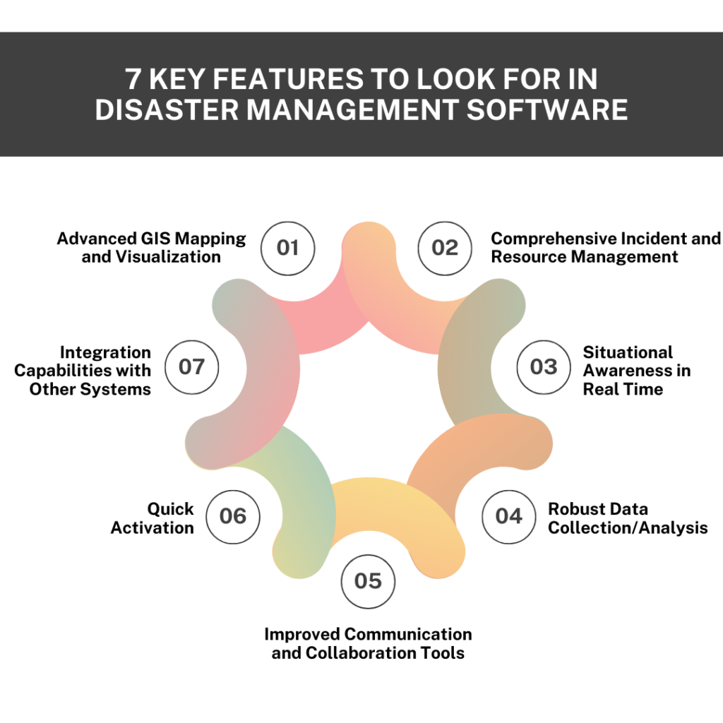
    #1. Advanced GIS Mapping and Visualization

    The fundamental capabilities of disaster management software are GIS mapping services and visualization. The GIS functionalities provide a real-time view of affected areas, evacuation routes, and resources required in a disaster scenario.

    • Dynamic Mapping: The package will feature dynamic hotspot updates, enabling real-time tracking of disaster changes. It will support layered mapping, allowing users to visualize different data layers such as infrastructure, hazard zones, and population density on the provided maps.
    • Interactive and 3D Maps: Zoom, pan, and click on maps for more information with detailed views of the area. 3D visualization is particularly helpful in urban environments to assess the impacts of disasters such as floods or landslides on buildings and terrain.
    • Scenario Simulations: Software that simulates scenarios allows the user to model possible disaster situations. This feature is crucial for city planners while trying to predict the aftereffects of an inevitable disaster that could affect the infrastructure.

    #2. Comprehensive Incident and Resource Management

    The tracking of an incident and the management of resources effectively become crucial during a disaster response situation. Comprehensive incident management ensures that the responders are well-informed and that the procedure is carried out as quickly as possible to cause minimal damage.

    • Incident Logging: Incident management software should be logged in real time. In ideal ones, there should be standardized reporting templates for logging critical incident information, such as location, severity, and nature of the disaster. Attachments of multimedia photos and videos help enhance situational awareness.
    • Resource Tracking: Real-time tracking of resources like workforce, equipment, and supplies. More sophisticated systems will be able to geolocate all resources accurately so that positioning can be determined with high precision. The system will track the availability and status of critical assets, such as medical equipment, ambulances, or rescue people.
    • Task Management: The automation of task assignment through the skills available from responders ensures that the right personnel handle appropriate challenges. Features for tracking progress allow users to gauge the completion of tasks in real time, which increases coordination.

    #3. Situational Awareness in Real Time

    Situational awareness during disaster scenes is essential. The disaster management software must integrate live feeds of data from various sources so that updated information is gotten across to teams for appropriate decision-making.

    • Data Feeds Integration: The software should search for information from meteorological services, emergency broadcasts, and social media monitoring. Real-time weather updates and public sentiment tracking will help define emerging issues early.
    • Impact Assessment Tools: One can assess the immediate effects of a disaster if such capability is available. This includes modules that look into damage assessment from satellite or drone imagery and community impact metrics that quantify how populations are affected.
    • Alerts: Best disaster management software should automatically send alerts upon predetermined thresholds. Additionally, it should also allow for multi-language communication to respond to different communities’ multifaceted diversity appropriately.

    #4. Robust Data Collection/Analysis

    Effective decision-making in a disaster situation strictly depends on proper and integrated data collection. Incident management software must present flexible tools customized to suit data collection/analysis.

    • Self-Customizable Data Forms: It should allow the users to create their own data forms with any configuration suitable to the needs of the information required for the incident. First responders can use the field data collection app to enter their information on-site.
    • Predictive Analytics: It should provide advanced capabilities and methods to predict natural disasters or resource needs based on historical analysis. Trending analysis reports and the database on lessons learned track past performances to provide insight into future planning.

    #5. Improved Communication and Collaboration Tools

    Communication during a disaster may either save or consume lives. The disaster management software should ensure multi-channel communication and involve safe collaboration environments.

    • Multi-Channel Communication: Alerts and updates should be duly sent through SMS, email, and push notifications to reach as many people as possible. The social media integration with the software will enable teams to give news about updates to people quickly.
    • Secure Messaging Platforms: There is communication between teams; sensitive information has to be encrypted and only accessible to authorized personnel. Role-based access control (RBAC) ensures that information only reaches the right people.
    • Collaboration Workspaces: When disaster strikes, responders need immediate sharing of documents, images, and plans. Therefore, collaboration workspaces, with real-time editing features, allow teams to make decisions and make vital changes without delay.

    #6. Quick Activation

    Time is of the essence in disaster management. Rapid activation of the emergency personnel and response plans would make all the difference between quick and non-responsive organisations to a disaster. Incident management software should enable rapid deployment of emergency operations centres and allow teams to activate pre-configured response plans with a button.

    • Pre-Configured Action Plans: The software should enable organizations to establish and implement pre-configured action plans for different situations, reducing response delay.
    • Predefined Interfaces According to Role: The predefined interfaces, according to the role, will allow the responders to quickly access the tools and information they need, meaning fast and effective mobilization.

    That means that teams hit the ground running and are on time to make things effective in terms of the mobilization of resources.

    #7. Integration Capabilities with Other Systems

    Disaster management software needs to integrate with existing systems to be operational seamlessly.

    • API Support: The application should offer APIs to interface with existing emergency management systems, GIS platforms, and municipal databases. This helps ease data flow between different agencies involved in disaster management.
    • Data Migration Tools: Such software/systems should provide handy data migration tools to support the importing of historical data into the new system, and compliance with interoperability standards is maintained to ensure that the systems interoperate with national and regional emergency management frameworks.

    Key Takeaways

    Urban disaster management requires a tailored approach. By developing essential features such as advanced GIS mapping, real-time resource tracking, data collection, training simulations, and more, organizations can better prepare themselves for disasters and respond more quickly.

    The disaster management software selects the right opportunity for ready cities to face the growing urban development challenges. The most essential characteristics of cities using SCS Tech disaster management software include proactive preparation, rapid response, and quick recovery.

  • How GIS Mapping Services is Transforming the Oil/Gas Sector?

    How GIS Mapping Services is Transforming the Oil/Gas Sector?

    Do you know the integration of GIS across various sectors, including oil and gas, is projected to grow at a CAGR of 12.5% and reach a market size of US $26.27 billion between the periods of 2024-30? With this growth, oil and gas companies are adopting GIS mapping services. GIS helps in optimizing pipeline routes and monitoring assets in real-time. It also improves safety protocols and analyzes large amounts of spatial data. This integration streamlines operations, reduces risks, and enhances decision-making.

    To know more about how GIS technology integration helps in achieving optimal results, read the blog that covers various aspects of the GIS mapping services integration with the oil and gas technology sector.

    GIS Workflow in Oil and Gas Operations

    What is the Role of GIS mapping services in the Oil and Gas Sector?

    GIS plays an important role in streamlining operations and saving costs in the oil and gas sector, we will discuss each factor in detail through the below-mentioned pointers:

    Exploration and Production (E&P)

    • This is the first stage in the oil and gas lifecycle; GIS here helps to integrate historical records, geological maps, seismic data, etc., to create effective reservoir modeling.
    • With these integrations, we identify locations for resource extraction and drilling. It helps in improving the accuracy of finding drilling locations and results in reduced exploration risks.
    • Reservoir modeling: a GIS mapping services feature helps visualize and model the size of the reservoir so accurate production estimates can be made.

    Asset Management and Infrastructure

    • Asset Management and Infrastructure in the Oil and Gas Sector with GIS is important for cost-effective infrastructure management, including storage, refineries, pipelines, rigs, etc.
    • Through spatial databases, GIS helps in asset maintenance and tracking. Operators can effectively determine on one single platform how the asset will be distributed across geographic locations, such as the exact location of pipelines, storage tanks, etc.
    • GIS technology also aids in optimized infrastructure planning by enabling optimal site selection, environmental considerations, and cost optimization. Additionally, it reduces risks through data integration from drones and satellites, allowing for in-depth inspections, particularly in offshore rigs and remote pipeline locations.

    Pipeline and Route Optimization

    • In the oil and gas sector, pipelines are the foundation for transporting crude oil, natural gas, and other petroleum products over long distances that can be challenging. Here, GIS plays a role in route optimization through planning and design, which is done by geospatial analysis of factors like terrain, land use, and environmental sensitivity. Route optimization is done for cost savings and less environmental disruption.
    • Listed below are a few important features offered by GIS for pipeline and route optimization.
      • Terrain and elevation analysis through slope stability analysis and analysis of elevation profiles
      • Integrating existing pipeline networks and faster access to maintenance facilities. Through predictive maintenance, one can perform a better assessment of temperature variations, terrain type, seismic activity, etc.
      • Enhancing risk management and safety through population density analysis, identification of high-risk zones, emergency response planning, etc.

    Field Data Collection and Remote Sensing

    • Integrating field data collection and remote sensing with GIS mapping enables remote data acquisition using satellite imagery, LiDAR, and aerial photography. This approach captures large-scale data over pipelines, refineries, and infrastructure. Additionally, UAVs equipped with GIS sensors provide in-depth data collection, enhancing overall accuracy.

    • Other key aspects include real-time field data collection through GPS integration and geotagging, environmental impact monitoring, sensitive ecosystem tracking, regulatory audits and inspections through data maps, etc.

    Seismic Data Analysis and Fault Line Mapping

    • Integrating GIS in India with seismic data analysis enhances vibrational data acquisition, and then we use geophones or hydrophone sensors to collect information on wave reflection.
    • Integration data also helps engineers analyze subsurface geological formations in 2D or 3D form.
    • GIS integrates seismic surveys, geological maps, and satellite imagery, which helps identify fault lines so that companies can make changes in drilling plans, develop stronger infrastructure, and develop safety protocols to mitigate the impact.

    Advantages of GIS mapping services in the Oil and Gas Sector

    The geographic information system helps the oil and gas sector by integrating tools that help in data management through data layering, emergency response planning, data sharing and collaboration, and more. Listed below are some key advantages:

    • Optimized Exploration and Drilling Operations
    • Supply Chain and Logistics Optimization
    • Enhanced Pipeline and Infrastructure Management
    • Sustainability through Optimized Resource Utilization
    • Reduction in Maintenance Costs
    • Enhanced Emergency Response and Incident Management
    • Enhanced Communication and Collaboration

    GIS Innovations and Trends Integrated by GIS Companies in India

    Listed below are a few upcoming GIS trends and innovations contributing to the transformation of the oil and gas industry:

    • Real-time data integration, such as satellite imagery and IoT sensors
    • AI and Machine learning for anomaly detection and optimization
    • Advanced geospatial analytics such as 3D modeling and spatial analysis
    • Blockchain for Data Security
    • Remote Sensing and UAVs through high-resolution aerial imagery and data collection
    • Enhanced reservoir modeling that helps in accurately predicting oil and gas reserves.

    Conclusion

    Integrating GIS technology in the oil and gas industry not only enhances operational efficiency but also transforms how we manage and ensure our resources and safety. By utilizing advanced spatial data analysis and innovative technologies, companies can achieve precise monitoring, proactive maintenance, and optimized resource usage. This strategic integration drives significant improvements, offering a competitive edge and unlocking new levels of operational excellence. Using these GIS capabilities could redefine your approach to industry challenges, setting the stage for future advancements and sustained success.

    If you are looking to capitalize on the benefits of GIS mapping services in the oil and gas industry solutions, then getting expert guidance from  SCS Tech India can be an optimal decision. Their solutions enhance precision, streamline management, and drive innovation, giving you a competitive edge while maximizing efficiency.


    FAQ

    • Can GIS help in predictive analytics in the oil and gas sector exploration?

    Yes, GIS technology helps in predictive analytics in the oil and gas sector exploration by integrating historical data with geospatial information, subsurface mapping, geological risk assessment, hydrocarbon movement prediction, and more.

    • Do GIS mapping services help in risk management in the oil and gas industry?

    Yes, GIS mapping services help in risk management by identifying high-risk zones, real-time monitoring of assets through drone and satellite monitoring, seismic risk prediction by spatial analysis, etc.

    • What are the innovations GIS companies in India are focusing on to transform the oil and gas sector in India?

    GIS companies in India are focusing on innovations like advanced remote sensing and satellite imagery, 3D reservoir modeling, seismic data integration, scalable cloud GIS platforms, hybrid energy systems, and more.

    • How can we use GIS technology in pipeline management in the oil and gas sector?

    GIS technology is important for pipeline management in the oil and gas sector as it helps detect leaks, corrosion, and pressure anomalies, ensure pipeline safety, reduce environmental risks, etc.

    (more…)

  • What to Look for When Choosing a GIS Mapping Service Provider

    What to Look for When Choosing a GIS Mapping Service Provider

    The GIS market is on track to hit $14.5 billion by 2025, fueled by its growing impact across sectors like transportation, space exploration, automotive design, and smart city planning. With such explosive growth, GIS is quickly becoming indispensable for industries looking to innovate and lead.

    This growth reflects that enterprises are now increasingly relying on GIS mapping services to enhance predictive modeling, optimize operations, and support strategic decision-making. As the demand for GIS solutions rises, selecting the right service provider becomes a critical focus on GIS mapping services that can offer precise geographic data to boost predictive modeling capabilities, optimize operations, and improve decision-making processes.

    Companies are focusing on GIS mapping service providers who not only offer robust systems that analyze, integrate, and display spatial or geographical data but also give tailored-based services as per the project demand to achieve business objectives. In this blog, we will focus on key factors that one should look for before selecting a GIS mapping services provider.

    Key Factors To Consider While Choosing A GIS Mapping Service Provider

    #1 Technical Expertise and Level of Qualification

    Delivering high-end GIS mapping services depends on skilled professionals who can efficiently handle GIS tools and technologies like big data handling, AI-driven geospatial analytics, etc., along with specialized projects like advanced spatial modeling. It is important to check that the service provider has a certification like GIS Professional (GISP).

    #2 Data Quality and Accuracy

    The data quality and accuracy are integral parts of GIS mapping as they impact the insights derived from spatial analysis. Poor-quality data can lead to increased GIS project costs and incorrect analysis, which can lead to wrong decisions.

    The following factors can be checked:

    • Check that the provider uses authoritative data sources and has a robust validation process, thereby maintaining quality and accuracy.
    • Look for providers offering in-depth metadata with information regarding data source, accuracy level, collection data, etc. to assess reliability.
    • Check whether the service provider is adhering to standards related to data accuracy set by various ISO or related bodies.
    • With a dynamic technological landscape, check that the provider is offering advanced data collection tools for better quality, like LiDAR, UAVs (Unmanned Aerial Vehicles), etc.

    #3 Service Offerings

    While choosing a GIS mapping service provider, it is important to explore what specialized and end-to-end services are offered and how they are aligned with your goal and can help you improve results. The key services offered by a GIS provider one can look for are given below:

    • End-to-end services, from the gathering of data to its processing, mapping, and final reporting for efficient project workflow, are the core services to be offered by GIS mapping service providers.
    • The service provider should offer integration of GIS data with other systems, such as CRM or ERP systems, for better utilization of data in enterprise operations.
    • Evaluate whether specialized services, like 3D modeling and visualization, are offered, mainly for urban planning/development and infrastructure-related projects. For projects involving customer mapping or asset management, the service provided should be able to provide geocoding and address matching.

    #4 Customer Service And Training

    The GIS mapping service provider should be able to offer the required customer service and training so that better utilization of GIS tools can be done to achieve the desired project outcomes. The key parameters to be looked at under the customer service and training component are

    • 24/7 Customer Support Service
    • Fast Response to Reduce Downtime
    • Comprehensive training programs, including workshops, webinars, etc.
    • Industry- or project-specific training
    • Training materials such as user manuals or video tutorials.
    • Effective feedback mechanism

    #5 Cost Structure

    While choosing a GIS mapping service provider, it is important to understand the different pricing models and how they align with your project and financial budget. In the chart below, different pricing models with key features and the right project alignment are mentioned.

    GIS Mapping services pricing model

    Other than the pricing models, cost transparency should be maintained by the service provider by highlighting the upfront fees and hidden costs like advanced customer support, data storage requirements, etc., so the organization can effectively manage contingency expenses.

    #6 Emerging Trends And Innovation Integration

    Staying updated with recent trends and innovations in GIS mapping that can be implemented in your enterprise and selecting the service provider as per the requirement is crucial for informed decision-making.

    Some of the latest innovations on the market are:

    • Real-time analytics
    • 3D GIS for better spatial visualization
    • Improved predictive analytics through machine learning and AI
    • Cloud-based GIS solution for scalability, better accessibility for remote teams, and flexibility
    • Geospatial Data Fusion to create comprehensive geospatial datasets by combining data from social media, satellites, and other sources.

    Conclusion

    The selection of the right GIS mapping service provider can be complex when you want to integrate specific requirements and advanced technologies.

    Evaluating the right GIS mapping service provider involves various factors, from technical qualification, customization, and integration to scalable solutions, as these factors help in making informed decisions that enhance an organization’s ability to leverage spatial information effectively.

    To ease out the process, consult experts from SCS Tech India to navigate the complexities and implement innovative approaches to optimize your spatial data management and have a competitive edge in the market by leveraging GIS technologies for your projects.

    FAQs

    1. What is the role of customer service when selecting a GIS mapping service provider?
      Customer service plays an important role when selecting a GIS mapping service provider for various factors like addressing issues promptly, offering required training, assisting in technical changes, and more to enhance the overall experience.
    2. What costs are involved in GIS mapping services?
      GIS mapping services include costs such as initial setup costs, software licenses, purchasing data, customizing the system, and fees involved in continuing support and maintenance.
    3. Are there any latest trends I should look after before choosing GIS mapping services?
      Yes, the current trends in GIS mapping services one should be aware of are real-time data processing, integration of machine learning for data analysis, 3D and VR mapping technologies, edge computing, and more.
    4. What are the core components of GIS mapping?
      The core components of GIS mapping include spatial data, hardware, GIS software, and database management. (more…)