Category: Smart Cities

  • GIS Mapping: 9 Use Cases That Are Powering Smart Cities & Infrastructure

    GIS Mapping: 9 Use Cases That Are Powering Smart Cities & Infrastructure

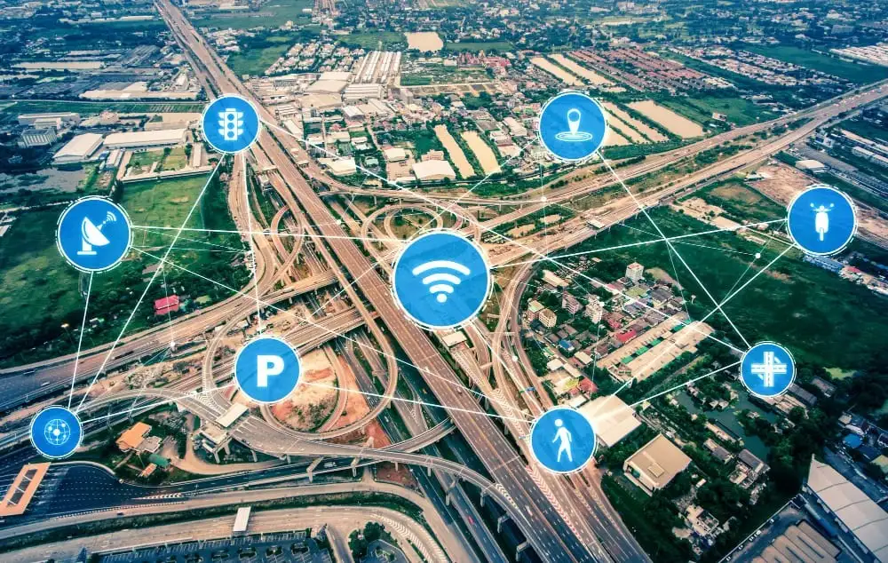
    Smart cities are no longer futuristic ideas as they are actively being designed, funded, and built across India. With rapid urban growth, rising infrastructure demand, and increasing pressure on resources, city planners and government agencies need smarter ways to manage land, water, transport, public services, and emergency response. This is where GIS mapping (Geographic Information Systems) has become a game-changer.

    GIS mapping is more than just digital maps. It enables decision-makers to visualize real-world data geographically, analyze patterns, forecast risks, and plan smarter infrastructure development. Whether a city is planning new roads, managing flood-prone zones, tracking public assets, or improving traffic flow, GIS provides a single, powerful layer of intelligence that connects everything.

    In this blog, we’ll explore what GIS mapping is, why it’s essential for smart cities, and the most high-impact GIS use cases that are transforming infrastructure and urban planning in 2026.

    What Is GIS Mapping and Why Does It Matter Today?

    GIS mapping is a technology that collects, stores, analyzes, and visualizes geographical or location-based data. It combines traditional mapping with modern data analytics, enabling organizations to answer key questions like:

    Where are the problems occurring?

    Why are they happening in specific locations?

    What areas are most vulnerable in the future?

    How can we optimize infrastructure planning and public service delivery?

    In simple terms: GIS turns location data into actionable intelligence.

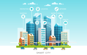
    For smart cities, GIS is essential because every urban system—roads, water pipelines, electricity networks, traffic signals, public safety, waste management—exists in a geographic space. GIS helps connect these systems and manage them more efficiently.

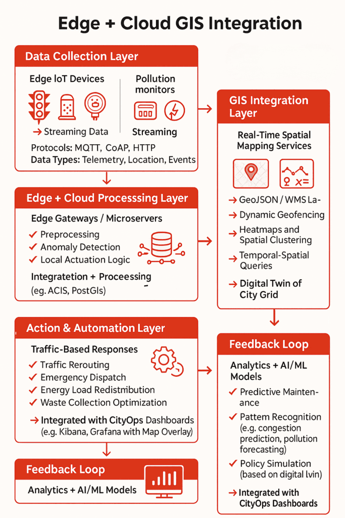
    How GIS Mapping Powers Smart City Development

    GIS mapping serves as the technological backbone of smart city development by synthesizing diverse, real-time data into a unified, actionable framework. By integrating layers such as transportation networks, land usage, and population distribution with critical utility infrastructure and environmental metrics, GIS allows urban planners to move beyond departmental silos.

    This multidimensional approach—further enriched by satellite and drone imagery—transforms the city into a visible, dynamic ecosystem where the relationship between streetlights, air quality, and traffic flow can be analyzed simultaneously. Ultimately, this geographic intelligence empowers leaders to make precise, data-driven decisions that improve efficiency and quality of life across the entire urban landscape.

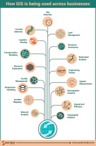
    Top 9 GIS Mapping Use Cases Powering Smart Cities & Infrastructure

    Let’s look at the most impactful and practical GIS applications being used in smart cities and infrastructure projects today.

    1. Urban Planning and Land Use Management

    Urban development requires structured planning—where to build, what to build, and how to ensure long-term sustainability. GIS helps planners identify growth patterns, land availability, and development constraints.

    GIS enables:

    • Zoning and land-use planning

    • Master planning for city expansion

    • Identifying suitable land parcels for public projects

    • Mapping unauthorized constructions and encroachments

    • Impact analysis of new infrastructure projects

    Instead of relying on static reports, smart city planners can visualize development scenarios using interactive GIS dashboards.

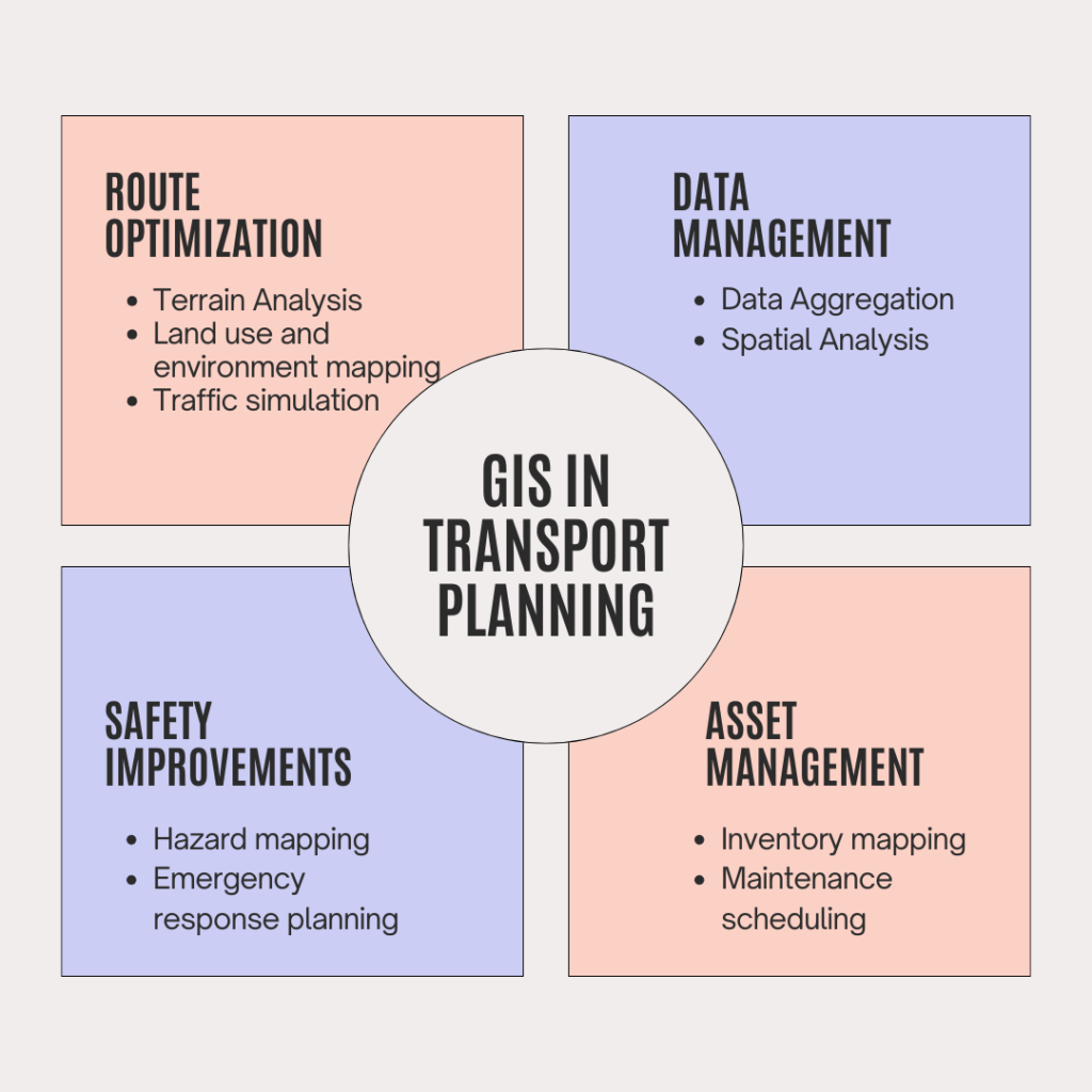
    2. Smart Transportation and Traffic Management

    Traffic congestion is one of the biggest challenges in urban India. Smart mobility depends on analyzing traffic flow, identifying bottlenecks, and optimizing routes for both private and public transport.

    With GIS mapping, authorities can:

    • Monitor congestion hotspots

    • Analyze accident-prone zones

    • Optimize traffic signals and junction layouts

    • Plan alternate routes and bypass corridors

    • Improve public transport route planning

    Over time, GIS can also support long-term initiatives such as integrated metro, bus, and multimodal transport networks by improving planning accuracy.

    3. Asset Management for Public Infrastructure

    Smart cities run on public assets: streetlights, water valves, power transformers, CCTV cameras, roads, bridges, signboards, and more. Managing these assets manually is costly and inefficient.

    GIS-based asset mapping helps governments and civic bodies:

    • Create an accurate inventory of city assets

    • Track asset condition and maintenance schedules

    • Identify asset gaps across regions

    • Reduce service downtime through faster repairs

    • Improve accountability through geo-tagged records

    This is one of the most practical and high-ROI uses of GIS, especially for municipal bodies focused on service delivery improvements.

    4. Water Supply and Pipeline Network Monitoring

    Water is one of the most critical—and stressed—resources for growing cities. Leakage, illegal connections, and poor monitoring can lead to heavy losses and supply disruption.

    GIS helps utilities manage water networks by enabling:

    • Mapping of pipeline networks and distribution zones

    • Leak detection and hotspot identification

    • Monitoring pressure zones and flow rates

    • Planning new water lines based on demand mapping

    • Visualizing real-time supply status across regions

    When integrated with IoT sensors, GIS becomes even more powerful, enabling real-time alerts and predictive maintenance.

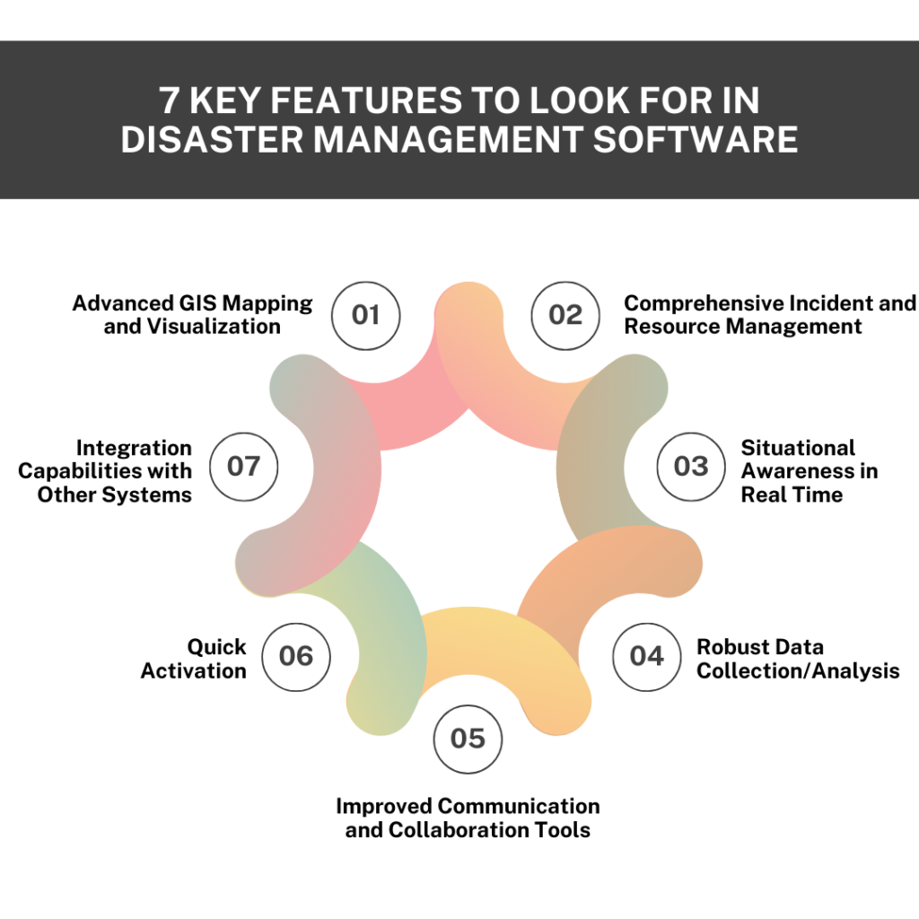
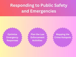
    5. Disaster Management and Emergency Response

    Whether it’s floods, landslides, fires, earthquakes, or industrial incidents, emergency response depends on speed and accurate situational awareness. GIS enables authorities to respond faster and allocate resources efficiently.

    GIS can support:

    • Flood risk mapping and drainage analysis

    • Identifying evacuation routes and shelter locations

    • Real-time incident mapping and resource allocation

    • Tracking emergency vehicles and field teams

    • Monitoring disaster impact zones using satellite imagery

    This makes GIS an essential tool not only for smart cities but also for climate resilience planning.

    6. Solid Waste Management and Sanitation Planning

    Solid waste management is a major operational challenge in cities. Routes must be optimized, bins must be tracked, and collection schedules need to be managed efficiently.

    GIS helps by enabling:

    • Geo-tagging of bins and collection points

    • Route optimization for waste collection vehicles

    • Identifying missed pickups or underserved areas

    • Planning landfill sites and waste transfer stations

    • Monitoring sanitation performance across zones

    This use case supports cleaner cities while reducing fuel consumption and operational costs.

    7. Smart Street Lighting and Energy Optimization

    Street lighting is one of the biggest municipal electricity expenses. Smart street lighting projects are powered by GIS through mapping and monitoring of lighting infrastructure.

    GIS supports:

    • Mapping existing streetlight points

    • Identifying high-need areas (dark spots)

    • Monitoring faults and maintenance schedules

    • Optimizing energy usage through smart controls

    This results in improved public safety while keeping energy spending under control.

    8. Environmental Monitoring and Sustainability Projects

    Smart cities must also be sustainable cities. GIS plays a vital role in monitoring environmental conditions and planning eco-friendly interventions.

    Common GIS applications include:

    • Air quality mapping and pollution hotspot tracking

    • Mapping green spaces and urban forest projects

    • Heat map analysis for urban heat islands

    • Water body monitoring and restoration planning

    • Noise pollution and waste dumping monitoring

    These insights help cities plan long-term environmental action instead of reactive measures.

    9. Smart Governance and Citizen Service Delivery

    Citizens expect fast, transparent, and efficient service delivery. GIS enables governance teams to manage issues geographically and improve response times.

    With GIS-enabled citizen service models, authorities can:

    • Map citizen complaints by ward/zone

    • Prioritize areas with high service gaps

    • Allocate field teams efficiently

    • Track service completion with geo-tagged proof

    • Improve accountability with data-based monitoring

    This leads to better citizen satisfaction and measurable improvements in municipal services.

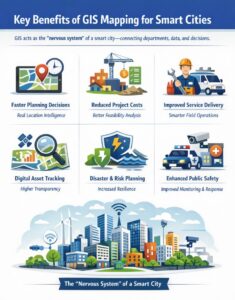
    Key Benefits of GIS Mapping for Smart Cities

    GIS brings value across planning, operations, and governance. Some of the most powerful benefits include:

    Key benefits of GIS mapping for smart cities including planning, cost reduction, resilience and public safety

    Wrapping Up!

    GIS mapping is no longer just a support tool—it has become a foundational technology driving smart city development and modern infrastructure planning. In 2026, cities that adopt GIS effectively gain a major advantage: they can plan smarter, respond faster, allocate resources efficiently, and deliver better public services.

    From transport and water management to disaster response and sustainability initiatives, GIS is empowering governments and enterprises to transform how cities function—making them more connected, resilient, and future-ready.

    For organizations working on smart city projects, partnering with a technology provider like SCS Tech India that understands GIS implementation at scale can make all the difference. With the right strategy, data systems, and deployment approach, GIS can become one of the highest-impact investments for infrastructure modernization.

  • What Happens When GIS Meets IoT: Real-Time Mapping for Smarter Cities

    What Happens When GIS Meets IoT: Real-Time Mapping for Smarter Cities

    Urban problems like traffic congestion and energy wastage are on the increase as cities get more connected. 

    While the Internet of Things (IoT) generates a great deal of data, it often lacks spatial awareness, so cities cannot respond in an effective manner. In practice, 74% of IoT projects are considered to fail, often due to issues like integration challenges, insufficient skills, and poorly defined business cases. 

    Including Geographic Information Systems (GIS) with IoT offers cities location-based real-time intelligence to make traffic, energy, and safety management decisions more informed. The integration of GIS with IoT is the key to transforming urban data into actionable intelligence that maximizes city operations.

    The Impact of IoT Without GIS Mapping: Why Spatial Context Matters

    In today’s intelligent cities, IoT devices are amassing enormous quantities of data regarding traffic, waste disposal, energy consumption, and others. Yet without the indispensable geographic context of GIS, such data can stay disconnected, rendering cities with siloed, uninterpretable data. 

    IoT data responds to the query of “what” is occurring, yet GIS responds to the all-important question of “where” it is occurring—and spatial awareness is fundamental for informed, timely decision-making.

    Challenges faced by cities without GIS mapping:

    • Limited Understanding of Data Location: IoT sensors can sense problems, such as an increase in traffic jams, but without GIS, one does not know where precisely the issue lies. Is it a concentrating bottleneck or a city-wide problem? Without geospatial context, deciding which routes to upgrade is a shot in the dark.
    • Inefficiency in Response Time: If the whereabouts of a problem are not known, it will take longer to respond to it. For example, waste collection vehicles can receive information about a full bin, but without GIS, it is not known which bin to service first. This can cause inefficiencies and delays.
    • Difficult Pattern Discovery: It’s difficult for urban planners to determine patterns if data isn’t geographically based. For instance, crime areas within a neighborhood won’t reveal themselves until you put crime data on top of traffic flow maps, retail maps, or other IoT maps.
    • Blind Data: Context-less data is worthless. IoT sensors are tracking all sorts of metrics, but without GIS to organize and visualize that data on a geographic basis, it’s often overwhelming and worthless. Cities may be tracking millions of data points with no discernible plan about how to react to them.

    By integrating GIS with IoT, cities can shift from reactive to proactive management, ensuring that urban dynamics are continuously improved in real-time.

    How Real-Time GIS Mapping Enhances Urban Management

    Edge + GIS Mapping

    IoT devices stream real-time telemetry—air quality levels, traffic flow, water usage—but without GIS, this data lacks geospatial context.

    GIS integrates these telemetry feeds into spatial data layers, enabling dynamic geofencing, hotspot detection, and live mapping directly on the city’s grid infrastructure. This allows city systems to trigger automated responses—such as rerouting traffic when congestion zones are detected via loop sensors, or dispatching waste trucks when fill-level sensors cross geofenced thresholds.

    Instead of sifting through unstructured sensor logs, operators get geospatial dashboards that localize problems instantly, speeding up intervention and reducing operational lag.

    That’s how GIS mapping services transform isolated IoT data points into a unified, location-aware command system for real-time, high-accuracy urban management.

    In detail, here’s how real-time GIS mapping improves urban management efficiency:

    1. Real-Time Decision Making

    With GIS, IoT data can be overlaid on a map, modern GIS mapping services enable cities to make on-the-fly decisions by integrating data streams directly into live, spatial dashboards, making responsiveness a built-in feature of urban operations. Whether it’s adjusting traffic signal timings based on congestion, dispatching emergency services during a crisis, or optimizing waste collection routes, real-time GIS mapping provides the spatial context necessary for precise, quick action.

    • Traffic Management: Real-time traffic data from IoT sensors can be displayed on GIS maps, enabling dynamic route optimization and better flow management. City officials can adjust traffic lights or divert traffic in real time to minimize congestion.
    • Emergency Response: GIS mapping enables emergency responders to access real-time data about traffic, weather conditions, and road closures, allowing them to make faster, more informed decisions.

    2. Enhanced Urban Planning and Resource Optimization

    GIS allows cities to optimize infrastructure and resources by identifying trends and patterns over time. Urban planners can examine data in a spatial context, making it easier to plan for future growth, optimize energy consumption, and reduce costs.

    • Energy Management: GIS can track energy usage patterns across the city, allowing for more efficient allocation of resources. Cities can pinpoint high-energy-demand areas and develop strategies for energy conservation.
    • Waste Management: By combining IoT data on waste levels with GIS, cities can optimize waste collection routes and schedules, reducing costs and improving service efficiency.

    3. Improved Sustainability and Liveability

    Cities can use real-time GIS mapping to make informed decisions that promote sustainability and improve liveability. With a clear view of spatial patterns, cities can address challenges like air pollution, water management, and green space accessibility more effectively.

    • Air Quality Monitoring: With real-time data from IoT sensors, GIS can map pollution hotspots and allow city officials to take corrective actions, like deploying air purifiers or restricting traffic in affected areas.
    • Water Management: GIS can help manage water usage by mapping areas with high consumption or leakage, ensuring that water resources are used efficiently and wastefully high-demand areas are addressed.

    4. Data-Driven Policy Making

    Real-time GIS mapping provides city officials with a clear, data-backed picture of urban dynamics. By analyzing data in a geographic context, cities can create policies and strategies that are better aligned with the actual needs of their communities.

    • Urban Heat Islands: By mapping temperature data in real-time, cities can identify areas with higher temperatures. This enables them to take proactive steps, such as creating more green spaces or installing reflective materials, to cool down the environment.
    • Flood Risk Management: GIS can help cities predict flood risks by mapping elevation data, rainfall patterns, and drainage systems. When IoT sensors detect rising water levels, real-time GIS data can provide immediate insight into which areas are at risk, allowing for faster evacuation or mitigation actions.

    Advancements in GIS-IoT Integration: Powering Smarter Urban Decisions

    The integration of GIS and IoT isn’t just changing urban management—it’s redefining how cities function in real time. At the heart of this transformation lies a crucial capability: spatial intelligence. Rather than treating it as a standalone concept, think of it as the evolved skill set cities gain when GIS and IoT converge.

    Spatial intelligence empowers city systems to interpret massive volumes of geographically referenced data—on the fly. And with today’s advancements, that ability is more real-time, accurate, and actionable than ever before. As this shift continues, GIS companies in India are playing a critical role in enabling municipalities to implement smart city solutions at scale.

    What’s Fueling This Leap in Capability?

    Here’s how recent technological developments are enhancing the impact of real-time GIS in urban management:

    • 5G Connectivity: Ultra-low latency enables IoT sensors—from traffic signals to air quality monitors—to stream data instantly. This dramatically reduces the lag between problem detection and response.
    • Edge Computing: By processing data at or near the source (like a traffic node or waste disposal unit), cities avoid central server delays. This results in faster analysis and quicker decisions at the point of action.
    • Cloud-Enabled GIS Platforms: Cloud integration centralizes spatial data, enabling seamless, scalable access and collaboration across departments.
    • AI and Predictive Analytics in GIS: With machine learning layered into GIS, spatial patterns can be not only observed but predicted. For instance, analyzing pedestrian density can help adjust signal timings before congestion occurs.
    • Digital Twins of Urban Systems: Many cities are now creating real-time digital replicas of their physical infrastructure. These digital twins, powered by GIS-IoT data streams, allow planners to simulate changes before implementing them in the real world.

    Why These Advancements Matter Now

    Urban systems are more complex than ever—rising populations, environmental stress, and infrastructure strain demand faster, smarter decision-making. What once took weeks of reporting and data aggregation now happens in real time. Real-time GIS mapping isn’t just a helpful upgrade—it’s a necessary infrastructure for:

    • Preemptively identifying traffic bottlenecks before they paralyze a city.
    • Monitoring air quality by neighborhood and deploying mobile clean-air units.
    • Allocating energy dynamically based on real-time consumption patterns.

    Rather than being an isolated software tool, GIS is evolving into a live, decision-support system. It is an intelligent layer across the city’s digital and physical ecosystems.

    For businesses involved in urban infrastructure, SCS Tech provides advanced GIS mapping services that take full advantage of these cutting-edge technologies, ensuring smarter, more efficient urban management solutions.

    Conclusion

    Smart cities aren’t built on data alone—they’re built on context. IoT can tell you what’s happening, but without GIS, you won’t know where or why. That’s the gap real-time mapping fills.

    When cities integrate GIS with IoT, they stop reacting blindly and start solving problems with precision. Whether it’s managing congestion, cutting energy waste, or improving emergency response, GIS and IoT are indeed gamechangers.

    At SCS Tech, we help city planners and infrastructure teams make sense of complex data through real-time GIS solutions. If you’re ready to turn scattered data into smart decisions, we’re here to help.

  • How GIS Mapping Services Is Changing Transport Planning for Smarter Roads and Railways?

    How GIS Mapping Services Is Changing Transport Planning for Smarter Roads and Railways?

    Are you aware that rising traffic congestion isn’t just slowing down commutes—it’s shortening lives? A study by the Harvard School of Public Health highlights the severity of this issue, highlighting the urgent need for advanced traffic management solutions. One promising approach is  (Geographic Information Systems) GIS mapping services.

    It offers innovative ways to optimize transport networks. But how are GIS technologies changing road and railway transport planning? How are they making roads and railways smarter and more sustainable?

    Read on further to learn how GIS significantly utilises data management, route optimization, asset management, and safety. GIS consultants play a key role in implementing these technologies effectively across industries. Also, discover how AI technology companies, through AI and cloud technology, can make future infrastructure smarter and more resilient.

    How GIS is Revolutionizing Transport Planning for Smarter Roads and Railways?


    How GIS mapping services enhance transport planning for smart roads and railways?

    #1. Improving Data Management in Transport Planning

    GIS mapping services provide a channel through which spatial data is essential to understanding the transport system and its planning. It can also be handled and analyzed crucially. It helps planners capture the big picture by combining multiple data sources, revealing insights into traffic patterns, land use, population distribution, etc.

    • Data Aggregation: GIS aggregates different data sources, such as satellite imagery, demographic data, and real-time traffic data. High-resolution satellite images reveal land use and infrastructure conditions. Meanwhile, demographic information highlights areas that need better connectivity. Traffic data from sensors and GPS devices help planners identify peak times and congestion hotspots.
    • Spatial Analysis: Utilizing GIS, planners can execute spatial analyses on how healthy regions are connected and the impact of new infrastructure. For example, they can determine service areas for public transportation or simulate how a new road would modify the local traffic patterns. Thus, it is possible to have improved investments in infrastructure and service planning.

    Enhanced data management by GIS mapping services helps planners understand transport networks holistically. It ensures that resources are applied where they are needed most.

    #2. Optimization of Routes in Roads and Railways

    Route optimization is one of the most potent applications of GIS in transport planning, thus helping to determine the best routes for new roads or railways. It makes route design easier because it can analyze the terrain, land use, and environmental features to minimize costs, avoid sensitive areas, and meet safety standards.

    • Terrain Analysis: Digital elevation models (DEMs) with GIS help planners review elevations and slopes to determine the least-cost construction routes. The process could be done using software like ArcGIS based on DEMs to look for steep slopes. This helps in creating alignments of new roads to increase safety.
    • Land Use and Environmental Mapping: Land use type mapping along the potential routes helps planners avoid sensitive environmental areas and comply with zoning regulations. Such analysis is essential in the design of routes that meet ecological and regulatory standards.
    • Traffic Simulation: GIS assists in traffic flow simulation, helping planners anticipate congestion and design better interventions. Real-time data on traffic will allow planners to foresee areas of congestion. This enables them to make infrastructure design adjustments that help avoid bottlenecks for more accessible and smoother traffic.

    These route optimizations ensure roads and railways are created with efficiency, sustainability, and reduced long-term costs.

    #3. Efficient Asset Management for Transport Infrastructure

    GIS mapping services serve as a means for transport agencies to handle their assets correctly, thereby keeping the transport infrastructure safe and reliable. Using GIS tools, one can provide detailed maps of assets like roads, bridges, and railways and then track and maintain their conditions.

    • Inventory Mapping: GIS asset databases will provide information on each asset’s condition, age, and maintenance history. For instance, ArcGIS’s Asset Management Module allows transport planners to visualize asset conditions so they can plan and schedule maintenance optimally.
    • Maintenance Scheduling: GIS can provide a basis for prioritizing maintenance based on urgency by analyzing historical data on asset wear and tear. This directs resources to the most critical areas. This approach to asset management through GIS enhances the lifespan of infrastructure and boosts overall safety and reliability.

    Asset management using GIS minimizes unexpected repairs but also maximizes investments in infrastructure, creating safer and more resilient transport networks.

    #4. Safety Improvements through GIS Mapping Services

    Safety in transport planning is one of the primary considerations, and through GIS mapping services, safety improvements can be ensured. As such, mapping identifies risk areas and designs effective responses in emergencies.

    • Hazard Mapping: With the help of GIS, hazardous places can be identified, like accident-prone zones or areas that are prone to natural disasters such as flooding. Accidents and environmental risks may be analyzed through GIS for patterns, which will help planners implement targeted safety improvements, like better signposting or road designs.
    • Emergency Response Planning: Transport agencies can support emergency planning by mapping critical infrastructures, hospitals, and fire stations using GIS. With real-time GPS, GIS enables transport agencies to make ready evacuation routes with quick responses towards emergencies.

    Safety through GIS-driven safety measures can reduce the possibility of accidents and improve preparedness for emergencies. This is achieved by creating transport systems that better protect the infrastructure and the community.

    Technological Innovations Towards Enhancing GIS in Transport Planning

    With the emergence of AI and cloud-based GIS solutions, the applications of GIS in transport planning are rapidly expanding.

    • AI and Predictive Analytics: AI-based GIS uses historical and real-time data to identify the need for maintenance and optimize traffic flow. Predictive models help transport planners forecast future traffic patterns, making it easier to design adaptable infrastructure.

    For instance, AI can analyze traffic and accident data to adjust signal timings or suggest new infrastructure that improves safety and flow.

    • Remote Sensing with Drones and Satellites: Drones capture high-resolution images of transport corridors with cameras and sensors. Rapid data gathering enhances the efficiency of planning and monitoring of infrastructure.

    Satellite imagery gives a broader view of land-use changes, providing valuable insights for planners. This helps them track how the expansion of urban areas is affecting transport needs.

    • Cloud-Based GIS for Collaborations: ArcGIS platforms offer the space to facilitate collaboration between transport planning projects. This includes collaboration from government agencies, private firms, and community organizations.

    The resource provisioning through the cloud is easily scalable as it can share the data without hassle. It also increases accessibility and flexibility to the GIS solutions.

    The above innovations make robust mapping services from GIS, ensuring accuracy in data, ease of collaboration, and efficiency of resources. This approach accounts for the complexities of transport planning.

    Conclusion

    As we look toward the future, GIS mapping services are set to transform transport planning, crafting road and rail networks that aren’t just routes but smart, sustainable pathways connecting us all. By integrating diverse data, route optimization, and asset management making it the bedrock of transport network design. This foundation will support both modern needs and future growth.

    GIS will play an even more vital role in shaping efficient and resilient transport systems as AI and cloud technologies advance. GIS companies in India like SCS Tech are at the forefront of this technology, and cities worldwide use GIS to create connected, future-proof networks. These networks are designed to be safe and sustainable.

  • 7 Key Features to Look for in Disaster Management Software for Urban Development

    7 Key Features to Look for in Disaster Management Software for Urban Development

    With expansion and growth comes an increase in the possibility of disaster occurrence, both natural and anthropogenic. There must be a designated focus on preparing cities for whatever nature brings. Leveraging technologies like natural disaster prediction can play a critical role in minimizing risks and enhancing preparedness. According to the Global Assessment Report (UNISDR, 2015), disasters cost an estimated $314 billion annually in the built environment alone.

    That’s where disaster management software steps into the scene, a crucial tool that helps cities plan, respond, and recover quickly in the face of crisis. But with so many out there, knowing what matters is what counts. Continue reading to learn the 7 essential characteristics to look for to deploy the most robust disaster management software for urban development.

    Here are 7 Key Features to Look for in Disaster Management Software

    7 Key Features to Look for in Disaster Management Software

    #1. Advanced GIS Mapping and Visualization

    The fundamental capabilities of disaster management software are GIS mapping services and visualization. The GIS functionalities provide a real-time view of affected areas, evacuation routes, and resources required in a disaster scenario.

    • Dynamic Mapping: The package will feature dynamic hotspot updates, enabling real-time tracking of disaster changes. It will support layered mapping, allowing users to visualize different data layers such as infrastructure, hazard zones, and population density on the provided maps.
    • Interactive and 3D Maps: Zoom, pan, and click on maps for more information with detailed views of the area. 3D visualization is particularly helpful in urban environments to assess the impacts of disasters such as floods or landslides on buildings and terrain.
    • Scenario Simulations: Software that simulates scenarios allows the user to model possible disaster situations. This feature is crucial for city planners while trying to predict the aftereffects of an inevitable disaster that could affect the infrastructure.

    #2. Comprehensive Incident and Resource Management

    The tracking of an incident and the management of resources effectively become crucial during a disaster response situation. Comprehensive incident management ensures that the responders are well-informed and that the procedure is carried out as quickly as possible to cause minimal damage.

    • Incident Logging: Incident management software should be logged in real time. In ideal ones, there should be standardized reporting templates for logging critical incident information, such as location, severity, and nature of the disaster. Attachments of multimedia photos and videos help enhance situational awareness.
    • Resource Tracking: Real-time tracking of resources like workforce, equipment, and supplies. More sophisticated systems will be able to geolocate all resources accurately so that positioning can be determined with high precision. The system will track the availability and status of critical assets, such as medical equipment, ambulances, or rescue people.
    • Task Management: The automation of task assignment through the skills available from responders ensures that the right personnel handle appropriate challenges. Features for tracking progress allow users to gauge the completion of tasks in real time, which increases coordination.

    #3. Situational Awareness in Real Time

    Situational awareness during disaster scenes is essential. The disaster management software must integrate live feeds of data from various sources so that updated information is gotten across to teams for appropriate decision-making.

    • Data Feeds Integration: The software should search for information from meteorological services, emergency broadcasts, and social media monitoring. Real-time weather updates and public sentiment tracking will help define emerging issues early.
    • Impact Assessment Tools: One can assess the immediate effects of a disaster if such capability is available. This includes modules that look into damage assessment from satellite or drone imagery and community impact metrics that quantify how populations are affected.
    • Alerts: Best disaster management software should automatically send alerts upon predetermined thresholds. Additionally, it should also allow for multi-language communication to respond to different communities’ multifaceted diversity appropriately.

    #4. Robust Data Collection/Analysis

    Effective decision-making in a disaster situation strictly depends on proper and integrated data collection. Incident management software must present flexible tools customized to suit data collection/analysis.

    • Self-Customizable Data Forms: It should allow the users to create their own data forms with any configuration suitable to the needs of the information required for the incident. First responders can use the field data collection app to enter their information on-site.
    • Predictive Analytics: It should provide advanced capabilities and methods to predict natural disasters or resource needs based on historical analysis. Trending analysis reports and the database on lessons learned track past performances to provide insight into future planning.

    #5. Improved Communication and Collaboration Tools

    Communication during a disaster may either save or consume lives. The disaster management software should ensure multi-channel communication and involve safe collaboration environments.

    • Multi-Channel Communication: Alerts and updates should be duly sent through SMS, email, and push notifications to reach as many people as possible. The social media integration with the software will enable teams to give news about updates to people quickly.
    • Secure Messaging Platforms: There is communication between teams; sensitive information has to be encrypted and only accessible to authorized personnel. Role-based access control (RBAC) ensures that information only reaches the right people.
    • Collaboration Workspaces: When disaster strikes, responders need immediate sharing of documents, images, and plans. Therefore, collaboration workspaces, with real-time editing features, allow teams to make decisions and make vital changes without delay.

    #6. Quick Activation

    Time is of the essence in disaster management. Rapid activation of the emergency personnel and response plans would make all the difference between quick and non-responsive organisations to a disaster. Incident management software should enable rapid deployment of emergency operations centres and allow teams to activate pre-configured response plans with a button.

    • Pre-Configured Action Plans: The software should enable organizations to establish and implement pre-configured action plans for different situations, reducing response delay.
    • Predefined Interfaces According to Role: The predefined interfaces, according to the role, will allow the responders to quickly access the tools and information they need, meaning fast and effective mobilization.

    That means that teams hit the ground running and are on time to make things effective in terms of the mobilization of resources.

    #7. Integration Capabilities with Other Systems

    Disaster management software needs to integrate with existing systems to be operational seamlessly.

    • API Support: The application should offer APIs to interface with existing emergency management systems, GIS platforms, and municipal databases. This helps ease data flow between different agencies involved in disaster management.
    • Data Migration Tools: Such software/systems should provide handy data migration tools to support the importing of historical data into the new system, and compliance with interoperability standards is maintained to ensure that the systems interoperate with national and regional emergency management frameworks.

    Key Takeaways

    Urban disaster management requires a tailored approach. By developing essential features such as advanced GIS mapping, real-time resource tracking, data collection, training simulations, and more, organizations can better prepare themselves for disasters and respond more quickly.

    The disaster management software selects the right opportunity for ready cities to face the growing urban development challenges. The most essential characteristics of cities using SCS Tech disaster management software include proactive preparation, rapid response, and quick recovery.

  • What to Look for When Choosing a GIS Mapping Service Provider

    What to Look for When Choosing a GIS Mapping Service Provider

    The GIS market is on track to hit $14.5 billion by 2025, fueled by its growing impact across sectors like transportation, space exploration, automotive design, and smart city planning. With such explosive growth, GIS is quickly becoming indispensable for industries looking to innovate and lead.

    This growth reflects that enterprises are now increasingly relying on GIS mapping services to enhance predictive modeling, optimize operations, and support strategic decision-making. As the demand for GIS solutions rises, selecting the right service provider becomes a critical focus on GIS mapping services that can offer precise geographic data to boost predictive modeling capabilities, optimize operations, and improve decision-making processes.

    Companies are focusing on GIS mapping service providers who not only offer robust systems that analyze, integrate, and display spatial or geographical data but also give tailored-based services as per the project demand to achieve business objectives. In this blog, we will focus on key factors that one should look for before selecting a GIS mapping services provider.

    Key Factors To Consider While Choosing A GIS Mapping Service Provider

    #1 Technical Expertise and Level of Qualification

    Delivering high-end GIS mapping services depends on skilled professionals who can efficiently handle GIS tools and technologies like big data handling, AI-driven geospatial analytics, etc., along with specialized projects like advanced spatial modeling. It is important to check that the service provider has a certification like GIS Professional (GISP).

    #2 Data Quality and Accuracy

    The data quality and accuracy are integral parts of GIS mapping as they impact the insights derived from spatial analysis. Poor-quality data can lead to increased GIS project costs and incorrect analysis, which can lead to wrong decisions.

    The following factors can be checked:

    • Check that the provider uses authoritative data sources and has a robust validation process, thereby maintaining quality and accuracy.
    • Look for providers offering in-depth metadata with information regarding data source, accuracy level, collection data, etc. to assess reliability.
    • Check whether the service provider is adhering to standards related to data accuracy set by various ISO or related bodies.
    • With a dynamic technological landscape, check that the provider is offering advanced data collection tools for better quality, like LiDAR, UAVs (Unmanned Aerial Vehicles), etc.

    #3 Service Offerings

    While choosing a GIS mapping service provider, it is important to explore what specialized and end-to-end services are offered and how they are aligned with your goal and can help you improve results. The key services offered by a GIS provider one can look for are given below:

    • End-to-end services, from the gathering of data to its processing, mapping, and final reporting for efficient project workflow, are the core services to be offered by GIS mapping service providers.
    • The service provider should offer integration of GIS data with other systems, such as CRM or ERP systems, for better utilization of data in enterprise operations.
    • Evaluate whether specialized services, like 3D modeling and visualization, are offered, mainly for urban planning/development and infrastructure-related projects. For projects involving customer mapping or asset management, the service provided should be able to provide geocoding and address matching.

    #4 Customer Service And Training

    The GIS mapping service provider should be able to offer the required customer service and training so that better utilization of GIS tools can be done to achieve the desired project outcomes. The key parameters to be looked at under the customer service and training component are

    • 24/7 Customer Support Service
    • Fast Response to Reduce Downtime
    • Comprehensive training programs, including workshops, webinars, etc.
    • Industry- or project-specific training
    • Training materials such as user manuals or video tutorials.
    • Effective feedback mechanism

    #5 Cost Structure

    While choosing a GIS mapping service provider, it is important to understand the different pricing models and how they align with your project and financial budget. In the chart below, different pricing models with key features and the right project alignment are mentioned.

    GIS Mapping services pricing model

    Other than the pricing models, cost transparency should be maintained by the service provider by highlighting the upfront fees and hidden costs like advanced customer support, data storage requirements, etc., so the organization can effectively manage contingency expenses.

    #6 Emerging Trends And Innovation Integration

    Staying updated with recent trends and innovations in GIS mapping that can be implemented in your enterprise and selecting the service provider as per the requirement is crucial for informed decision-making.

    Some of the latest innovations on the market are:

    • Real-time analytics
    • 3D GIS for better spatial visualization
    • Improved predictive analytics through machine learning and AI
    • Cloud-based GIS solution for scalability, better accessibility for remote teams, and flexibility
    • Geospatial Data Fusion to create comprehensive geospatial datasets by combining data from social media, satellites, and other sources.

    Conclusion

    The selection of the right GIS mapping service provider can be complex when you want to integrate specific requirements and advanced technologies.

    Evaluating the right GIS mapping service provider involves various factors, from technical qualification, customization, and integration to scalable solutions, as these factors help in making informed decisions that enhance an organization’s ability to leverage spatial information effectively.

    To ease out the process, consult experts from SCS Tech India to navigate the complexities and implement innovative approaches to optimize your spatial data management and have a competitive edge in the market by leveraging GIS technologies for your projects.

    FAQs

    1. What is the role of customer service when selecting a GIS mapping service provider?
      Customer service plays an important role when selecting a GIS mapping service provider for various factors like addressing issues promptly, offering required training, assisting in technical changes, and more to enhance the overall experience.
    2. What costs are involved in GIS mapping services?
      GIS mapping services include costs such as initial setup costs, software licenses, purchasing data, customizing the system, and fees involved in continuing support and maintenance.
    3. Are there any latest trends I should look after before choosing GIS mapping services?
      Yes, the current trends in GIS mapping services one should be aware of are real-time data processing, integration of machine learning for data analysis, 3D and VR mapping technologies, edge computing, and more.
    4. What are the core components of GIS mapping?
      The core components of GIS mapping include spatial data, hardware, GIS software, and database management. (more…)
  • Smart Cities and e Governance Solutions: The Role of Advanced AI and ML Services in Urban Development

    Smart Cities and e Governance Solutions: The Role of Advanced AI and ML Services in Urban Development

    In recent years, the concept of “smart cities” has captured the imagination of urban planners and technologists alike. Today, such cities are the way of living.

    With investments in smart city technology expected to reach 65% by 2040, the impact is undeniable.

    But what exactly makes a city “smart”? At its core, a smart city leverages advanced technologies like Al and ML to enhance the quality of life for its citizens, improve efficiency in public services, and promote sustainable urban development.

    This article explores how smart cities leverage Al and ML to address urban challenges and drive sustainable development.

    Governance in Smart Cities: Who are the Stakeholders?

    Image Source:

    All stakeholders participate in the development of industries, decision-making, and planning work, and they resolve issues collaboratively with the correct technology. These smart cities have many stakeholders, such as:

    • Private sectors
    • Citizens
    • Public sectors
    • Government

    Understanding the Value of AI Technology for Smart Cities

    AI is not just a profitable sector but also has the power to improve cities. Due to the quick process of modern-day connectivity, growing demand for IoT (Internet of Things) technology, and the birth of 5G, AI software for smart cities has turned into a massive business.

    Back in 2019, the AI sector had a value of $673.8 million, but in 2025, those figures will stand at $4.9 billion. But it has become much easier for all the AI programs to process and analyze all the information because of the:

    • Interconnected data banks
    • 5G connectivity
    • Modern-day smart technologies

    All these things have helped in resolving various issues in city management. Having AI technology can also assist all cities in opting for the correct changes at an efficient and quick pace. 

    How to Handle the Development of Smart Cities?

    Image Source:

    Urban development is a challenging task, and all developments must be properly designed, tested, and researched to satisfy various stakeholders. When you plan to handle smart city development, you have to conduct many studies and check several boxes. 

    At times, the bureaucracy stands in front of effective problem-solving. For instance, German officials in Berlin declared that it took them several years to install a proper bicycle lane in the city.

    But these days, if APIs (Application Programming Interfaces), heat maps, and AI all together, the government will gain entry to an enormous amount of information. The government can use the information to make accurate changes and informed decisions to improve city life.

    How ML and AI Technologies Revolutionise Urban Settings?

    The AI ML services have a massive potential to revolutionize the urban setting, which can lead to transformative advancements in many areas of city life. Take a look at the table below to gain more information:

    Pointers Description
    Allowing Smart Services and Governance Both ML and AL can change the public and governance services within urban settings. AI-powered intelligent systems can enhance the decision-making process, citizen engagement, and virtual assistance. For instance, virtual assistants and chatbots can offer efficient and personalized egovernance solutions to all citizens by addressing all their needs and queries. The AI algorithm will analyse massive sets of information to help with making data-driven decisions in areas like policy formulation and urban planning.
    Encouraging the Resilient and Sustainable Cities Both machine learning and artificial intelligence can aid in making resilient and sustainable cities. The ML algorithms will examine the sensor data, historical records, and climatic changes that will help support the disaster response and environmental control adequately.  With the help of ML and AL, cities can easily improve the usage of resources, optimize waste management methods, and lessen the environmental influence.
    Improve the Urban Infrastructure Artificial intelligence and machine learning technologies can optimize urban infrastructure. It can do so by improving resource administration, sustainability, and efficacy. The ML algorithms will analyze the information from different sources to optimize the environmental impact of energy consumption at smart grips and even lessen the expenses. Besides that, AI techniques can be easily applied to optimize the flow of traffic and intelligent conveyance systems, reduce congestion, and improve mobility.
    Advancing Public Security and Safety ML and AI technologies can improve the safety of the general public in various urban settings. AI algorithms will use intelligent monitoring methods to analyze the video feeds and identify all the real-time suspicious activities or threats. Training the machine learning models will assist law enforcement and predict crime patterns in bold crime deterrence effectively.
    Improvements in the Healthcare Industry AI technologies provide many possibilities for the healthcare sector. It will allow you to manage all the medical records, check the bed status, schedule online appointments in private and government hospitals, use smart inventory handling of medical supplies, and offer surgical assistance. AI technologies will not just aid in curing various health ailments but also stop them via early predictions and detections.

    Wrapping Up

    Both AI and ML technologies play pivotal roles in advancing smart city development, impacting critical areas such as traffic monitoring, advanced security systems, waste management, and urban governance. Collaborating with innovators and startups across private and public sectors is essential for creating effective IT solutions that enhance societal enjoyment, safety, comfort, and livability.

    SCS Tech India Pvt Ltd excels in delivering top-tier IT infrastructure solutions tailored for urban planning and development. Additionally, the company offers a comprehensive range of services, including enterprise solutions, e-governance, robotic process automation, and geographic information systems (GIS), reinforcing its commitment to shaping sustainable and efficient urban environments.

  • The Role of GIS Companies in Smart City Initiatives

    The Role of GIS Companies in Smart City Initiatives

    With over 55% of the world’s population now living in urban areas, the success and sustainability of these regions depend heavily on how well cities can manage their resources and address contingencies. GIS technology provides the backbone for these efforts, offering comprehensive solutions for urban planning, infrastructure management, environmental monitoring, and public safety. 

    Geographical Information Systems (GIS) technology is a cornerstone of modern urban development and management. GIS companies in India leverage this sophisticated technology to undertake a wide array of critical tasks—from designing and planning new urban spaces to the redevelopment of heritage cities. 

    In this blog, we discuss the multifaceted roles of GIS companies in India, emphasizing their contributions to smart city development and the extensive benefits they offer to urban environments. From economic growth and business support to transportation management and disaster response, GIS technology is revolutionizing how cities operate and thrive in an increasingly complex world.

    Significance of GIS Companies in the Smart City Framework

    Both small and large GIS companies in India offer essential tools and services for smart city development. Smaller firms might focus on specific tasks like traffic management, while larger organizations provide a comprehensive range of services from a central hub. 

    The Geographical information system software technology enables the use of locational data to make informed decisions, significantly contributing to smart city initiatives.

    Supporting Local Businesses

    GIS technology assists local businesses in maintaining visibility to potential customers, thereby boosting the economic prosperity of cities. When combined with public utility, topographic, environmental, and demographic data, GIS becomes a powerful tool for various industries. 

    Image Source:

    Applications like Google Maps exemplify how GIS can update information on demographics, public utilities, networks, roads, and local businesses, aiding decision-making processes.

    Environmental Sustainability and Monitoring

    Smart cities strive to be environmentally sustainable, and GIS companies play a crucial role in this by providing environmental monitoring services. The different methods to predict natural disasters used by GIS companies are as follows: 

    • Managing natural resources
    • Tracking changes in green areas
    • Mapping pollution levels

    Additionally, GIS aids in planning water conservation, waste management, and renewable energy projects, fostering healthier urban environments.

    Tracking the Water Sources

    A city’s underground and overground water sources are known as the lifeline of its people. Instead of utilizing the invasive process, the GIS companies in India use remote sensors to track down the water flow in the city. This helps identify whether or not a drought or impending flood occurs because of construction work.

    Response to Emergencies and Public Safety

    GIS-based tools enhance public safety and emergency response capabilities by integrating spatial data with incident management systems. GIS companies enable authorities to: 

    • Optimizing the emergency responses
    • Planning out the law enforcement-related activities
    • Mapping all the crime hotspots

    If there is a natural disaster, the GIS companies in India will use the incident command system in disaster management to coordinate rescue efforts, resource allocation, and damage assessment. This will lead to an efficient and instant response, aid recovery, and reduce loss.

    Economic Developments

    Through a detailed spatial analysis, companies can use GIS technology to find the best opportunities for economic development. Cities can pull in businesses by displaying their market potential, demographic trends, and real estate.

    GIS will also help in supporting tourism as it can point out all the amenities and attractions in a city, which will contribute towards economic growth.

    Transportation and Traffic

    For all the smart cities, managing traffic is highly essential. GIS companies can use the GIS system to analyze traffic patterns, manage public transportation systems, and optimize routes.

    These companies will also be able to integrate the GIS devices into the GIS platforms to deliver live updates on the traffic. This will enhance mobility and alleviate congestion.

    Urban Development and Planning

    Image Source:

    With the help of GIS technology, companies can help with the interpretation of spatial data, analysis, and visualization. All these things are compulsory for urban planning.

    Many planners utilize this particular technology to map the present infrastructure, model upcoming developments, and assess land usage.

    By doing so, planners can make correct decisions on environmental management, public-related services, and zoning the transportation networks.

    Understanding the Benefits of GIS Technology

    The GIS technology is equipped with countless advantages, and the table below will give you detailed information on them.

    GIS Technology Benefits The Description
    Disaster Management Emergency planning and risk assessment can improve response and preparedness during natural disasters.
    Market Analysis  Analysis of spatial data and demographics will help support the marketing approaches and business locations.
    Visualization Offering a visual representation with maps can improve communication and understanding. 
    Agriculture Provides support for crop management and accurate farming and helps monitor all agricultural activities.
    Education Helps in offering various tools for teaching environmental science, geography and many other fields.
    Crime Mapping Aids in analyzing all the crime patterns to improve public safety and law enforcement.
    Utility Management Helps in managing the infrastructure with numerous utilities like gas, electricity and water.
    Historical Preservation Enables the management and preservation of all the cultural heritages and historical locations. 

    Final Thoughts

    The GIS companies in India play a completely multifaceted part In the smart city industries. The GIS-based devices and tools that they have in store are compulsory for creating livable, sustainable, and efficient cities. This will make the GIS companies indispensable partners in the smart city environment. 

    Furthermore, at SCS Tech India PVT Ltd, we offer GIS-based solutions and services across the globe. Leveraging avant-garde technology, our offerings include enterprise solutions, cloud computing, eGoverance, blockchain solutions, IT infrastructure, digital transformation, and utility and energy solutions. 

    Our innovative services and solutions establish a robust digital foundation in today’s transformed world. Take advantage of our services across diverse sectors, including agriculture, education, finance, and healthcare. Get in touch with us to learn more!

  • The Impact of eGovernance Solutions on Government Efficiency

    The Impact of eGovernance Solutions on Government Efficiency

    Amidst the global surge of globalization, citizens worldwide are increasingly cognizant of their rights, pressing for transparency and efficiency from their governing bodies. To meet these burgeoning demands, traditional structures are no longer found ill-equipped to meet these burgeoning demands for streamlined public service delivery.

    In this dynamic landscape, the imperative for innovative models and systems like eGovernance has never been more pronounced. eGovernance solutions have fundamentally heralded a seismic shift in the efficiency and efficacy of governmental operations.

    This blog serves as a dedicated exploration into the transformative power of eGovernance solutions, illuminating how these advanced technologies redefine organizational performance, drive cost-efficiency, and ultimately shape a government sector that is not just efficient but also citizen-centric.

    Unveiling the Efficiency Powerhouse: eGovernance Solutions

    E-Governance, also called digital governance, focuses on using Information and Communication Technology to improve governmental processes, enhance transparency, and handle its operations and services. This encompasses a wide range of solutions, including:

    Online portals

    These simplified and easily accessible platforms create an opportunity for citizens to receive information and perform various tasks at any time. Whether it is getting a renewed license or applying for a permit, online portals enable citizens to do so as and when they want to do it.

    Data management systems

    Due to an intervention of an eGovernance solution, data is captured across departments to form a coherent database. This results in greater efficiency in handling requests, quick decision-making, and proper utilization of resources.

    Mobile applications

    Now that people are busier than ever, mobile apps are a useful way for citizens to interact with their government remotely. It can be very helpful for rural areas or those with little or no internet access in particular.

    Electronic Document Management (EDM)

    These are systems that help in the production, storage, and retrieval of documents. This cuts out paper-based systems, which reduces the time, money, and physical space required to store equipment.

    How eGovernance Solutions Enhance Efficiency?

    To understand it better let’s talk about India where the use of digital identification called Aadhaar has transformed the government services delivery system. Aadhaar verification has ensured that those in need of the welfare programs get the support they need through the right channels hence minimizing fraud instances and enhancing the targeting and delivery of social goods. According to estimates by the World Bank, Aadhaar saved over $1 billion of the Indian government’s expenses within a few years of its usage.

    Now let’s discuss in detail about how exactly eGovernance solutions enhance efficiency:

    Reduced Administrative Burden

    The eGovernance solutions replicate functions to reduce paperwork and manual data entry jobs. This saves considerable staff time, so they can handle many other issues and deliver better service to their customers.

    Faster Service Delivery

    By performing transactions online through different applications and portals, citizens can access the services without a problem. This has the effect of cutting the time clients spend waiting and enhancing service provision.

    Improved Decision-Making

    The experience gathered from the eGovernance systems helps governments to make decisions based on data analysis on current or real-time performance. It further helps in the efficient utilization of resources and the proper formulation of policies.

    Enhanced Transparency and Accountability

    One of the very important features of implementing eGovernance is that it provides citizens with easy access to government data and information. This also promotes honesty and efficiency in the public sector as the accountability is shifted to the citizens.

    Even though efficiency is a primary benefit, eGovernance has ripple effects. These solutions promote government-citizen interaction, cut down on government expenditure through the use of technology, and increase favorable conditions for businesses leading to an improved economy.

    The Road Ahead: Embracing the Future of Governance

    E-Governance is not a one-bullet solution; instead, it is an evolutionary model. While embracing the best practices in this field, eGovernance solutions must also adapt to the changes that accompany the progression of technology. Through incorporating innovation and encouraging learning within governmental organizations, governments need to be flexible to meet the continually demanding needs of the citizens within the digital era.

    Investing in eGovernance Solutions: A Wise Choice for a Brighter Future

    It is not only about the realization of eGovernance solutions but also about the creation of future governance landscapes. Technology, when adopted fully in the governance processes, provides a more efficient, accountable, and participative society. This, in turn, helps to strengthen the trust between the citizens and their government, which is the key to a better life and a more sustainable future.

    By investing in eGovernance solutions, governments can create a more efficient, transparent, and citizen-friendly environment.

    Contact us today to learn how SCS Tech India’s tailored solutions can enhance public sector service delivery.

  • The Role of GIS in Natural Disaster Management

    The Role of GIS in Natural Disaster Management

    For business owners, preparing for natural disasters is paramount to safeguarding their operations and employees. That’s where Geographic Information Systems (GIS) come into play.

    In this blog, we’ll explore how geographical information system software, especially the solutions offered by companies in India, plays a vital role in disaster management. It provides invaluable support, from predicting where disasters might strike to guiding emergency responses.

    Join us as we uncover how GIS can empower businesses to protect their assets and ensure continuity during natural calamities.

    Understanding GIS and Its Applications in Natural Disaster Management

    Natural disasters can have devastating effects on communities and businesses alike. However, geographical information system software offers a powerful tool set to help mitigate these risks and manage the aftermath more effectively.

    What is GIS?

    At its core, GIS is a technology that captures, analyzes, and presents spatial or geographical data. This includes information such as maps, satellite imagery, and geographic coordinates.

    Applications in Disaster Management

    GIS plays a crucial role in various stages of disaster management:

    1. Prevention and Preparedness: Geographical information system software helps authorities identify risks and develop mitigation strategies by mapping potential hazards, vulnerable areas, and critical infrastructure. For example, it can be used to map flood zones, earthquake fault lines, and areas prone to wildfires.
    2. Response and Relief: it enables real-time monitoring and coordination of response efforts during a disaster. Emergency responders can use GIS to track the movement of a hurricane, identify affected areas, and deploy resources where needed most. GIS also helps establish temporary shelters, evacuation routes, and medical facilities.
    3. Recovery and Reconstruction: After the disaster has passed, it plays a vital role in assessing damages and planning reconstruction efforts. By mapping out the extent of destruction, it helps prioritize areas for recovery and allocate resources effectively. Additionally, it aids in monitoring environmental impacts, such as soil erosion or pollution, and planning restoration projects.

    GIS Methods to Predict Natural Disasters

    GIS technology is crucial in predicting and forecasting and in natural disaster management, enabling proactive decision-making and resource allocation.

    1. Remote Sensing and Satellite Imagery: geographical information system software utilizes satellite imagery to monitor environmental changes and indicators of impending disasters.
    2. Modelling and Simulation: it models analyze historical data and environmental factors to forecast hurricanes, floods, and landslides.
    3. Early Warning Systems: it integrates real-time data to develop early warning systems for timely alerts and proactive measures.

    Real-Time Monitoring and Response with GIS

    Timely response to natural disasters is critical for minimizing damage and saving lives. GIS technology enables real-time monitoring and coordinated response efforts.

    1. Data Integration: GIS platforms integrate real-time data from various sources, providing up-to-date insights into evolving disaster scenarios.
    2. Situational Awareness: it visualizes critical information on interactive maps, enhancing situational awareness for emergency response teams.
    3. Resource Allocation: it helps prioritize response efforts by efficiently identifying areas at the most significant risk and allocating resources.
    4. Coordination: it facilitates collaboration among multiple agencies, ensuring a unified and effective disaster response.

    GIS Companies in India: Leading in Disaster Management

    India boasts several GIS companies specializing in disaster management solutions. These companies offer tailored expertise and innovative technologies to effectively predict, monitor, and respond to natural disasters management.

    1. Expert Solutions: GIS companies in India provide cutting-edge solutions for flood mapping, landslide prediction, and more, enhancing disaster resilience.
    2. Government Collaboration: They collaborate closely with government agencies, integrating GIS into disaster management frameworks to streamline response efforts.
    3. Capacity Building: These companies offer training programs to equip officials and responders with GIS skills, empowering communities to mitigate disaster impact.
    4. Community Engagement: Through outreach programs, they raise awareness and promote preparedness measures among local communities.
    5. Innovation: These companies are leaders in innovation. They invest in research to develop new disaster prediction and response technologies.

    Conclusion

    In conclusion, geographical information system software(GIS) play a pivotal role in every phase of disaster management, from prediction to recovery. Through advanced technologies and innovative solutions, GIS empowers communities and authorities to anticipate, monitor, and respond to natural disasters precisely and efficiently. GIS companies in India are at the forefront of this effort in India, offering expertise, solutions, and collaboration to enhance disaster resilience nationwide.

    As businesses navigate the complexities of disaster management, leveraging GIS technology becomes increasingly essential. By partnering with GIS companies in India and embracing innovative solutions, businesses can strengthen their disaster preparedness, protect their assets, and contribute to the safety and well-being of their communities.

    Visit SCS Tech India’s website today to explore how its GIS solutions can support your disaster management initiatives.

    Together, let us harness the power of GIS to build a safer, more resilient future for all.

  • How technology is making our everyday better

    How technology is making our everyday better

    All technologies that have emerged and thrived thus far have been invented to meet the needs of society, as it is rightly said that necessity is the mother of invention. Without a doubt, technology has made our lives easier over the last two decades. Technology has made our lives better in a number of ways, from communicating with people around the world from the convenience of your home to operating a full-fledged business without a physical site.

    We live in a capitalist society, which means that many technological advances are made by businesses looking to improve their products/services or their ability to market their offerings. Over the years, new technology has emerged with the goal of making business operations more beneficial and effective.

    Business Efficiency

    The business world is being swept away by a tidal wave of exponential technological progress. Today’s marketplace provides numerous opportunities to improve, adapt, and advance using available technology. The use of business analytics has proven to be beneficial in improving the customer experience. Such technology-powered business tools have propelled various aspects of business to new heights. Personalized messaging and user behavior analysis have also assisted businesses in establishing a fruitful presence in the market.

    Fast track Communication

    The only certain answer to how technology has improved our lives is that it has changed the way we communicate with one another dramatically. It has resulted in the development of several modes of electronic communication, including smartphone communication and social media. Now that civilization has advanced, instantaneous, error-free communication is widely accessible. Speed is undeniably the most significant advancement that technology has made in communication. We can now converse quickly and effortlessly from the convenience of our homes.

    Advanced Lifestyle

    Throughout history, societies have been reshaped by technology. Technology has had a significant impact on how humans behave and operate in the world. Technological advancements all around us are ongoing. New innovations are appearing, and they are undoubtedly influencing our way of life. Because of technological advancements, our lives are now vastly different from those of previous generations Transportation, agriculture, and education are just a few areas where technology is present and having an impact. On the other hand, the Internet of Things (IoT) has greatly simplified our lives. Through the medium of IoT, smart homes and advanced electronic gadgets have significantly improved our daily routines. It has simplified many aspects of life.

    Superior Trade

    Transactions are much simpler and more efficient than they were previously. On the consumer side, innovations such as the credit card and the rise of e-commerce have made it easier than ever for businesses to sell goods and services to customers at their leisure. However, transactions on a large scale are much easier on a B2B level. Foreign transactions like these are now much easier – and they may become even easier as blockchain, an emerging technology, gains traction.

    Information Accessibility

    Technology has had a significant impact on how we transfer and access information. Nowadays, we can get any information we want at the touch of a button. We are constantly searching the internet for answers and gathering information. If one learns how to surf more skillfully, technology is readily available to us, both in terms of authenticity and relevancy.

    We’ve gotten to the point where it’s difficult to imagine life without technology. The quality of life for people has considerably increased. Technology has altered our behavior and operations by infiltrating every aspect of our lives. Technology has made our lives better in a number of areas, including networking, healthcare, and communication.