Category: transport

  • Logistics Firms Are Slashing Fuel Costs with AI Route Optimization—Here’s How

    Logistics Firms Are Slashing Fuel Costs with AI Route Optimization—Here’s How

    Route optimization that are based on static data and human choice tend to fall short of possibilities to save money, resulting in inefficiencies and wasted fuel use.

    Artificial intelligence route optimization fills the gap by taking advantage of real-time data, predictive algorithms, and machine learning that dynamically alter routes in response to current conditions, including changes in traffic and weather. Using this technology, logistics companies can not only improve delivery time but also save huge amounts of fuel—lessening costs as well as environmental costs.

    In this article, we’ll dive into how AI-powered route optimization is transforming logistics operations, offering both short-term savings and long-term strategic advantages.

    What’s Really Driving the Fuel Problem in Logistics Today?

    Per gallon of gasoline costs $3.15. But that’s not the problem logistics are dealing with. The problem is the inefficiency at multiple points in the delivery process. 

    Here’s a breakdown of the key contributors to the fuel problem:

    • Traffic and Congestion: Delivery trucks idle almost 30% of the time in traffic conditions in urban regions. Static route plans do not take into consideration real-time traffic congestion, which results in excess fuel consumption and late delivery.
    • Idling and Delays: Cumulative waiting times at the delivery points or loading/unloading stations. Idling raises the fuel consumption level and lowers productivity overall.
    • Inefficient Rerouting: Drivers often have to rely on outdated route plans, which fail to adapt to sudden changes like road closures, accidents, or detours, leading to inefficient rerouting and excess fuel use.
    • Poor Driver Habits: Poor driving habits—like speeding, harsh braking, or rapid acceleration—can reduce fuel efficiency by as much as 30% on highways and 10 – 40% in city driving.
    • Static Route Plans: Classical planning tends to presume that the first route is the optimal route, without considering actual-time environmental changes.

    While traditional route planning focuses solely on distance, the modern logistics challenge is far more complex.

    The problem isn’t just about distance—it’s about the time between decision-making moments. Decision latency—the gap between receiving new information (like traffic updates) and making a change—can have a profound impact on fuel usage. With every second lost, logistics firms burn more fuel.

    Traditional methods simply can’t adapt quickly enough to reduce fuel waste, but with the addition of AI, decisions can be automated in real-time, and routes can be adjusted dynamically to optimize the fuel efficiency.

    The Benefits of AI Route Optimization for Logistic Companies

    AI Route Optimization for Logistics Companies

    1. Reducing Wasted Miles and Excessive Idling

    Fuel consumption is heavily influenced by wasted time. 

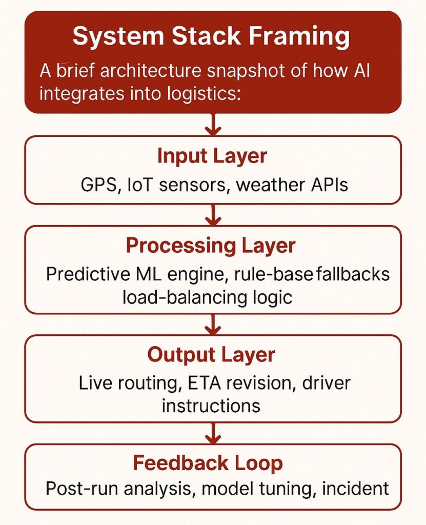
    Unlike traditional systems that rely on static waypoints or historical averages, AI models are fed with live inputs from GPS signals, driver telemetry, municipal traffic feeds, and even weather APIs. These models use predictive analytics to detect emerging traffic patterns before they become bottlenecks and reroute deliveries proactively—sometimes before a driver even encounters a slowdown.

    What does this mean for logistics firms?

    • Fuel isn’t wasted reacting to problems—it’s saved by anticipating them.
    • Delivery ETAs stay accurate, which protects SLAs and reduces penalty risks.
    • Idle time is minimized, not just in traffic but at loading docks, thanks to integrations with warehouse management systems that adjust arrival times dynamically.

    The AI chooses the smartest options, prioritizing consistent movement, minimal stops, and smooth terrain. Over hundreds of deliveries per day, these micro-decisions lead to measurable gains: reduced fuel bills, better driver satisfaction, and more predictable operational costs.

    This is how logistics firms are moving from reactive delivery models to intelligent, pre-emptive routing systems—driven by real-time data, and optimized for efficiency from the first mile to the last.

    1. Smarter, Real-Time Adaptability to Traffic Conditions

    AI doesn’t just plan for the “best” route at the start of the day—it adapts in real time. 

    Using a combination of live traffic feeds, vehicle sensor data, and external data sources like weather APIs and accident reports, AI models update delivery routes in real time. But more than that, they prioritize fuel efficiency metrics—evaluating elevation shifts, average stop durations, road gradient, and even left-turn frequency to find the path that burns the least fuel, not just the one that arrives the fastest. This level of contextual optimization is only possible with a robust AI/ML service that can continuously learn and adapt from traffic data and driving conditions.

    The result?

    • Route changes aren’t guesswork—they’re cost-driven.
    • On long-haul routes, fuel burn can be reduced by up to 15% simply by avoiding high-altitude detours or stop-start urban traffic.
    • Over time, the system becomes smarter per region—learning traffic rhythms specific to cities, seasons, and even lanes.

    This level of adaptability is what separates rule-based systems from machine learning models: it’s not just a reroute, it’s a fuel-aware, performance-optimized redirect—one that scales with every mile logged.

    1. Load Optimization for Fuel Efficiency

    Whether a truck is carrying a full load or a partial one, AI adjusts its recommendations to ensure the vehicle isn’t overworking itself, driving fuel consumption up unnecessarily. 

    For instance, AI accounts for vehicle weight, cargo volume, and even the terrain—knowing that a fully loaded truck climbing steep hills will consume more fuel than one carrying a lighter load on flat roads. 

    This leads to more tailored, precise decisions that optimize fuel usage based on load conditions, further reducing costs.

    What Does AI Route Optimization Actually Work?

    AI route optimization is transforming logistics by addressing the inefficiencies that traditional routing methods can’t handle. It moves beyond static plans, offering a dynamic, data-driven approach to reduce fuel consumption and improve overall operational efficiency. Here’s a clear breakdown of how AI does this:

    Predictive vs. Reactive Routing

    Traditional systems are reactive by design: they wait for traffic congestion to appear before recalculating. By then, the vehicle is already delayed, the fuel is already burned, and the opportunity to optimize is gone.

    AI flips this entirely.

    It combines:

    • Historical traffic patterns (think: congestion trends by time-of-day or day-of-week),
    • Live sensor inputs from telematics systems (speed, engine RPM, idle time),
    • External data streams (weather services, construction alerts, accident reports),
    • and driver behavior models (based on past performance and route habits)

    …to generate routes that aren’t just “smart”—they’re anticipatory.

    For example, if a system predicts a 60% chance of a traffic jam on Route A due to a football game starting at 5 PM, and the delivery is scheduled for 4:45 PM, it will reroute the vehicle through a slightly longer but consistently faster highway path—preventing idle time before it starts.

    This kind of proactive rerouting isn’t based on a single event; it’s shaped by millions of data points and fine-tuned by machine learning models that improve with each trip logged. With every dataset processed, an AI/ML service gains more predictive power, enabling it to make even more fuel-efficient decisions in future deliveries. Over time, this allows logistics firms to build an operational strategy around predictable fuel savings, not just reactive cost-cutting.

    Real-Time Data Inputs (Traffic, Weather, Load Data)

    AI systems integrate:

    • Traffic flow data from GPS providers, municipal feeds, and crowdsourced platforms like Waze.
    • Weather intelligence APIs to account for storm patterns, wind resistance, and road friction risks.
    • Vehicle telematics for current load weight, which affects acceleration patterns and optimal speeds.

    Each of these feeds becomes part of a dynamic route scoring model. For example, if a vehicle carrying a heavy load is routed into a hilly region during rainfall, fuel consumption may spike due to increased drag and braking. A well-tuned AI system reroutes that load along a flatter, dryer corridor—even if it’s slightly longer in distance—because fuel efficiency, not just mileage, becomes the optimized metric.

    This data fusion also happens at high frequency—every 5 to 15 seconds in advanced systems. That means as soon as a new traffic bottleneck is detected or a sudden road closure occurs, the algorithm recalculates, reducing decision latency to near-zero and preserving route efficiency with no human intervention.

    Vehicle-Specific Considerations

    Heavy-duty trucks carrying full loads can consume up to 50% more fuel per mile than lighter or empty ones, according to the U.S. Department of Energy. That means sending two different trucks down the same “optimal” route—without factoring in grade, stop frequency, or road surface—can result in major fuel waste.

    AI takes this into account in real time, adjusting:

    • Route incline based on gross vehicle weight and torque efficiency
    • Stop frequency based on vehicle type (e.g., hybrid vs. diesel)
    • Fuel burn curves that shift depending on terrain and traffic

    This level of precision allows fleet managers to assign the right vehicle to the right route—not just any available truck. And when combined with historical performance data, the AI can even learn which vehicles perform best on which corridors, continually improving the match between route and machine.

    Automatic Rerouting Based on Traffic/Data Drift

    AI’s real-time adaptability means that as traffic conditions change, or if new data becomes available (e.g., a road closure), the system automatically reroutes the vehicle to a more efficient path. 

    For example, if a major accident suddenly clogs a key highway, the AI can detect it within seconds and reroute the vehicle through a less congested arterial road—without the driver needing to stop or call dispatch. 

    Machine Learning: Continuous Improvement Over Time

    The most powerful aspect of AI is its machine learning capability. Over time, the system learns from outcomes—whether a route led to a fuel-efficient journey or created unnecessary delays. 

    With this knowledge, it continuously refines its algorithms, becoming better at predicting the most efficient routes and adapting to new challenges. AI doesn’t just optimize based on past data; it evolves and gets smarter with every trip.

    Bottom Line

    AI route optimization is not just a technological upgrade—it’s a strategic investment. 

    Firms that adopt AI-powered planning typically cut fuel expenses by 7–15%, depending on fleet size and operational complexity. But the value doesn’t stop there. Reduced idling, smarter rerouting, and fewer detours also mean less wear on vehicles, better delivery timing, and higher driver output.

    If you’re ready to make your fleet leaner, faster, and more fuel-efficient, SCS Tech’s AI logistics suite is built to deliver exactly that. Whether you need plug-and-play solutions or a fully customised AI/ML service, integrating these technologies into your logistics workflow is the key to sustained cost savings and competitive advantage. Contact us today to learn how we can help you drive smarter logistics and significant cost savings.

  • Understanding Big Data in GIS Applications: How It Shapes Our World

    Understanding Big Data in GIS Applications: How It Shapes Our World

    What if we could predict traffic jams, track pollution spread, and optimize city planning—all in real-time? Significant data infusion into geographical information systems (GIS) and advanced GIS services has made all these possible. The geospatial data analytics market has been growing globally, valued at $88.3 billion since 2020. This growth shows how organizations are using big data in GIS applications to make smarter decision

    In this blog, let’s discuss how Big Data is revolutionizing GIS applications, from cloud-based platforms to drone mapping services in India, and how GIS and IoT solve real-world problems.

    What Is GIS and Why Big Data Matters?

    GIS is a tool that enables us to visualize, analyze, and interpret spatial data—that is, data associated with specific locations on Earth. Think of it as a map with multiple layers of information, showing everything from land use to population density. Paired with Big Data—massive datasets with variety and speed—GIS transforms into a powerhouse for understanding complex relationships.

    For instance:

    • Big Data from IoT Sensors: The sensors in smart cities monitor real-time air quality, traffic, and temperature and feed into GIS systems with updated knowledge.
    • Crowdsourced Data: Platforms like OpenStreetMap enable individuals to share local knowledge, which feeds into maps with detailed information and accuracy.

    How Big Data Empowers GIS Applications

    Big data in GIS applications transforming mapping
    Big data in GIS applications transforming mapping

    Big Data empowers GIS in ways that methods of the past could not. Here’s how:

    1. Urban Planning Made Smarter

    • Land Use Analysis: Satellite imagery coupled with socioeconomic data helps planners track changes in land use over time. This ensures cities grow sustainably.
    • Transportation Modeling: GPS data from vehicles helps optimize routes and reduce congestion. For example, public transport systems can change routes dynamically based on traffic patterns.
    • Community Engagement: Interactive maps allow citizens to visualize and comment on urban projects, fostering transparency.

    2. Disaster Management: Saving Lives

    • Risk Assessment: GIS analyzes weather patterns and historical data to pinpoint areas at risk of flooding or earthquakes.
    • Real-Time Monitoring: During disasters, data from IoT devices and social media feeds helps responders understand the situation instantly.
    • Post-Disaster Recovery: Aerial drone images provide clear visuals of affected areas, speeding up relief efforts.

    3. Environmental Monitoring: Protecting the Planet

    • Climate Studies: Long-term satellite data reveals how vegetation and glaciers change over time due to global warming.
    • Biodiversity Conservation: GIS maps endangered species’ habitats, helping identify critical areas that require conservation.
    • Pollution Tracking: Air quality sensors feed into GIS systems that track how pollution spreads throughout cities, helping policymakers take action.

    4. Public Health: Monitoring and Controlling Diseases

    • Outbreak Mapping: GIS helped to visualize the case patterns in the COVID-19 pandemic. It allowed authorities to focus their resources on high-risk areas.
    • Resource Allocation: Through GIS, hospitals and clinics analyze population density in the area to provide better services.

    5. Logistics and Transportation: Moving Smarter

    • Route Optimization: Companies like UPS apply GIS to analyze traffic and deliver packages faster.
    • Fleet Management: GPS-enabled trucks feed the GIS system with location data, thus enabling real-time tracking and efficient route planning.

    Cutting-edge technologies in GIS

    GIS is growing with exciting technologies that make it even more powerful:

    Cloud-Based GIS Platforms

    Cloud technology has revolutionized GIS, making it accessible and scalable:

    • Real-Time Data Processing: Platforms like Esri’s ArcGIS Online allow seamless spatial data sharing and processing.
    • Collaboration: Teams can work on the same map from anywhere, fostering innovation and efficiency.
    • Cost-Effectiveness: Cloud-based GIS eliminates the need for expensive hardware, making it ideal for organizations of all sizes.

    Drone Mapping Services in India

    India’s rapid adoption of drone technology is transforming GIS applications:

    • Precision Mapping: Drones take high-resolution images for infrastructure projects and agriculture.
    • Disaster Response: Drones provide critical aerial visuals to aid recovery after natural disasters.
    • Urban Planning: Cities like Bangalore use drone data to plan better transportation and housing.

    GIS and IoT Applications

    IoT devices, from weather stations to traffic sensors, feed GIS systems with valuable real-time data:

    • Smart Cities: Sensors monitor everything from electricity usage to water flow, making for more innovative and sustainable urban environments.
    • Agriculture: IoT-enabled sensors monitor soil moisture and crop health for farmers to optimize yields.
    • Environmental Monitoring: Networks of IoT devices measure air and water quality, feeding GIS with critical ecological data.

    Challenges in Integrating Big Data with GIS

    With all its benefits, big data in GIS applications is fraught with its challenges:

    • Data Quality: Inaccurate or out-of-date data can result in poor decisions. Validation is a continuous process.
    • Technical Expertise: Professionals must be trained in geospatial analysis and data science, which requires extensive training.
    • Privacy Issues: The use of personal location data raises ethical issues. Clear policies and transparency are critical to building public trust.

    Future Directions for Big Data in GIS

    The integration of emerging technologies will redefine GIS:

    • AI and Machine Learning: These technologies will further power predictive analytics in GIS, automating pattern recognition and forecasting.
    • Cloud-Based GIS Platforms: Cloud storage will make smaller organizations more accessible and collaborative.
    • Drone Mapping Services: Drones equipped with GIS technology will continue to provide high-resolution data for agriculture, urban planning, and disaster response in India.
    • GIS and IoT Applications: IoT networks expand the scope of real-time monitoring from innovative city management to wildlife conservation.

    Conclusion

    The intersection of big data in GIS applications has opened doors for new understanding and solutions to complex geographic problems. From improving urban planning to enhancing disaster response and protecting the environment, GIS in India is playing a vital role in shaping a more innovative and sustainable world.

    As cloud-based GIS platforms and drone mapping services in India continue to evolve, companies like SCS Tech play an important role in driving innovation and delivering robust solutions. By addressing challenges such as data quality and privacy, we can utilize the full potential of Big Data in GIS applications, creating solutions that truly make a difference.


  • How GIS Mapping Services Is Changing Transport Planning for Smarter Roads and Railways?

    How GIS Mapping Services Is Changing Transport Planning for Smarter Roads and Railways?

    Are you aware that rising traffic congestion isn’t just slowing down commutes—it’s shortening lives? A study by the Harvard School of Public Health highlights the severity of this issue, highlighting the urgent need for advanced traffic management solutions. One promising approach is  (Geographic Information Systems) GIS mapping services.

    It offers innovative ways to optimize transport networks. But how are GIS technologies changing road and railway transport planning? How are they making roads and railways smarter and more sustainable?

    Read on further to learn how GIS significantly utilises data management, route optimization, asset management, and safety. GIS consultants play a key role in implementing these technologies effectively across industries. Also, discover how AI technology companies, through AI and cloud technology, can make future infrastructure smarter and more resilient.

    How GIS is Revolutionizing Transport Planning for Smarter Roads and Railways?


    How GIS mapping services enhance transport planning for smart roads and railways?

    #1. Improving Data Management in Transport Planning

    GIS mapping services provide a channel through which spatial data is essential to understanding the transport system and its planning. It can also be handled and analyzed crucially. It helps planners capture the big picture by combining multiple data sources, revealing insights into traffic patterns, land use, population distribution, etc.

    • Data Aggregation: GIS aggregates different data sources, such as satellite imagery, demographic data, and real-time traffic data. High-resolution satellite images reveal land use and infrastructure conditions. Meanwhile, demographic information highlights areas that need better connectivity. Traffic data from sensors and GPS devices help planners identify peak times and congestion hotspots.
    • Spatial Analysis: Utilizing GIS, planners can execute spatial analyses on how healthy regions are connected and the impact of new infrastructure. For example, they can determine service areas for public transportation or simulate how a new road would modify the local traffic patterns. Thus, it is possible to have improved investments in infrastructure and service planning.

    Enhanced data management by GIS mapping services helps planners understand transport networks holistically. It ensures that resources are applied where they are needed most.

    #2. Optimization of Routes in Roads and Railways

    Route optimization is one of the most potent applications of GIS in transport planning, thus helping to determine the best routes for new roads or railways. It makes route design easier because it can analyze the terrain, land use, and environmental features to minimize costs, avoid sensitive areas, and meet safety standards.

    • Terrain Analysis: Digital elevation models (DEMs) with GIS help planners review elevations and slopes to determine the least-cost construction routes. The process could be done using software like ArcGIS based on DEMs to look for steep slopes. This helps in creating alignments of new roads to increase safety.
    • Land Use and Environmental Mapping: Land use type mapping along the potential routes helps planners avoid sensitive environmental areas and comply with zoning regulations. Such analysis is essential in the design of routes that meet ecological and regulatory standards.
    • Traffic Simulation: GIS assists in traffic flow simulation, helping planners anticipate congestion and design better interventions. Real-time data on traffic will allow planners to foresee areas of congestion. This enables them to make infrastructure design adjustments that help avoid bottlenecks for more accessible and smoother traffic.

    These route optimizations ensure roads and railways are created with efficiency, sustainability, and reduced long-term costs.

    #3. Efficient Asset Management for Transport Infrastructure

    GIS mapping services serve as a means for transport agencies to handle their assets correctly, thereby keeping the transport infrastructure safe and reliable. Using GIS tools, one can provide detailed maps of assets like roads, bridges, and railways and then track and maintain their conditions.

    • Inventory Mapping: GIS asset databases will provide information on each asset’s condition, age, and maintenance history. For instance, ArcGIS’s Asset Management Module allows transport planners to visualize asset conditions so they can plan and schedule maintenance optimally.
    • Maintenance Scheduling: GIS can provide a basis for prioritizing maintenance based on urgency by analyzing historical data on asset wear and tear. This directs resources to the most critical areas. This approach to asset management through GIS enhances the lifespan of infrastructure and boosts overall safety and reliability.

    Asset management using GIS minimizes unexpected repairs but also maximizes investments in infrastructure, creating safer and more resilient transport networks.

    #4. Safety Improvements through GIS Mapping Services

    Safety in transport planning is one of the primary considerations, and through GIS mapping services, safety improvements can be ensured. As such, mapping identifies risk areas and designs effective responses in emergencies.

    • Hazard Mapping: With the help of GIS, hazardous places can be identified, like accident-prone zones or areas that are prone to natural disasters such as flooding. Accidents and environmental risks may be analyzed through GIS for patterns, which will help planners implement targeted safety improvements, like better signposting or road designs.
    • Emergency Response Planning: Transport agencies can support emergency planning by mapping critical infrastructures, hospitals, and fire stations using GIS. With real-time GPS, GIS enables transport agencies to make ready evacuation routes with quick responses towards emergencies.

    Safety through GIS-driven safety measures can reduce the possibility of accidents and improve preparedness for emergencies. This is achieved by creating transport systems that better protect the infrastructure and the community.

    Technological Innovations Towards Enhancing GIS in Transport Planning

    With the emergence of AI and cloud-based GIS solutions, the applications of GIS in transport planning are rapidly expanding.

    • AI and Predictive Analytics: AI-based GIS uses historical and real-time data to identify the need for maintenance and optimize traffic flow. Predictive models help transport planners forecast future traffic patterns, making it easier to design adaptable infrastructure.

    For instance, AI can analyze traffic and accident data to adjust signal timings or suggest new infrastructure that improves safety and flow.

    • Remote Sensing with Drones and Satellites: Drones capture high-resolution images of transport corridors with cameras and sensors. Rapid data gathering enhances the efficiency of planning and monitoring of infrastructure.

    Satellite imagery gives a broader view of land-use changes, providing valuable insights for planners. This helps them track how the expansion of urban areas is affecting transport needs.

    • Cloud-Based GIS for Collaborations: ArcGIS platforms offer the space to facilitate collaboration between transport planning projects. This includes collaboration from government agencies, private firms, and community organizations.

    The resource provisioning through the cloud is easily scalable as it can share the data without hassle. It also increases accessibility and flexibility to the GIS solutions.

    The above innovations make robust mapping services from GIS, ensuring accuracy in data, ease of collaboration, and efficiency of resources. This approach accounts for the complexities of transport planning.

    Conclusion

    As we look toward the future, GIS mapping services are set to transform transport planning, crafting road and rail networks that aren’t just routes but smart, sustainable pathways connecting us all. By integrating diverse data, route optimization, and asset management making it the bedrock of transport network design. This foundation will support both modern needs and future growth.

    GIS will play an even more vital role in shaping efficient and resilient transport systems as AI and cloud technologies advance. GIS companies in India like SCS Tech are at the forefront of this technology, and cities worldwide use GIS to create connected, future-proof networks. These networks are designed to be safe and sustainable.