Category: Uncategorized

  • AI-Powered Public Health Surveillance Systems with AI/ML Service

    AI-Powered Public Health Surveillance Systems with AI/ML Service

    Public health surveillance has always depended on delayed reporting, fragmented systems, and reactive measures. AI/ML service changes that structure entirely. Today, machine learning models can detect abnormal patterns in clinical data, media signals, and mobility trends, often before traditional systems register a threat. But building such systems means understanding how AI handles fragmented inputs, scales across regions, and turns signals into decisions.

    This article maps out what that architecture looks like and how it’s already being used in real-world health systems.

    What Is an AI-Powered Public Health Surveillance System?

    An AI-powered public health surveillance system continuously monitors, detects, and analyzes signals of disease-related events in real-time, before these events contaminate the overall population.

    It does this by combining large amounts of data from multiple sources, including hospital records, laboratory results, emergency department visits, prescription trends, media articles, travel logs, and even social media content. AI/ML service models trained to identify patterns and anomalies scan these inputs constantly to flag signs of unusual health activity.

    How AI Tracks Public Health Risks Before They Escalate

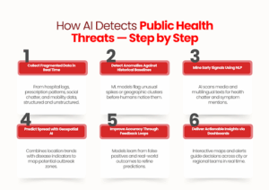
    AI surveillance doesn’t just collect data; it actively interprets, compares, and predicts. Here’s how these systems identify early health threats before they’re officially recognized.

    1. It starts with signals from fragmented data

    AI surveillance pulls in structured and unstructured inputs from numerous real-time sources: 

    • Syndromic surveillance reports (i.e., fever, cough, and respiratory symptoms)
    • Hospitalizations, electronic health records, and lab test trends
    • News articles, press wires, and social media mentions
    • Prescription spikes for specific medications
    • Mobility data (to track potential spread patterns)

    These are often weak signals, but AI picks up subtle shifts that human analysts might miss.

    2. Pattern recognition models flag anomalies early

    AI systems compare incoming data to historical baselines.

    Once the system detects unusual increases or deviations (e.g., a sudden surge in flu-like symptoms in a given location), it creates an internal alert for the performance monitoring system.

    For example, BlueDot flagged the COVID-19 cluster in Wuhan by observing abnormal cases of pneumonia in local news articles before any warnings emerged from other global sources.

    3. Natural Language Processing (NLP) mines early outbreak chatter

    AI reads through open-source texts in multiple languages to identify keywords, symptom mentions, and health incidents, even in informal or localized formats.

    4. Geospatial AI models predict where a disease may move next

    By combining infection trends with travel data and population movement, AI can forecast which regions are at risk days before cases appear.

    How it helps: Public health teams can pre-position resources and activate responses in advance.

    5. Machine learning models improve with feedback

    Each time an outbreak is confirmed or ruled out, the system learns.

    • False positives are reduced
    • High-risk variables are weighted better
    • Local context gets added into future predictions

    This self-learning loop keeps the system sharp, even in rapidly changing conditions.

    6. Dashboards convert data into early warning signals

    The end result is a structured insight for decision-makers.

    Dashboards visualize risk zones, suggest intervention priorities, and allow for live monitoring across regions.

    Key Components Behind a Public Health AI System

    AI-powered surveillance relies on a coordinated system of tools and frameworks, not just one algorithm or platform. Every element has a distinct function in converting unprocessed data into early detection.

    1. Machine Learning + Anomaly Detection

    Tracks abnormal trends across millions of real-time data points (clinical, demographic, syndromic).

    • Used in: India’s National Public Health Monitoring System
    • Speed: Flagged unusual patterns 54× faster than traditional frameworks

    2. Hybrid AI Interfaces

    Designed for lab and frontline health workers to enhance data quality and reduce diagnostic errors.

    • Example: Antibiogo, an AI tool that helps technicians interpret antibiotic resistance results
    • Connected to: Global platforms like WHONET

    3. Epidemiological Modeling

    Estimates the spread, intensity, or incidence of diseases over time using historical data.

    • Use case: France used ML to estimate annual diabetes rates from administrative health records
    • Value: Allows for non-communicable disease surveillance, not only outbreak detection

    Together, these elements create a surveillance system able to record, interpret, and respond to real-time health threats, quickly and more correctly than ever before by manual means.

    How Cities and Health Bodies Are Using AI Surveillance in the Real World

    AI-powered public health surveillance is already being applied in focused contexts, by cities, health departments, and evidence-based programs to identify threats sooner and respond with exactness.

    The following are three real-world examples that illustrate how AI isn’t simply reviewing data; it’s optimizing frontline response.

    1. Identifying TB Earlier in Disadvantaged Populations

    In Nagpur, where TB is still a high-burden disease, mobile vans with AI-powered chest X-ray diagnostics are being deployed in slum communities and high-risk populations.

    These devices screen automatically, identifying probable TB cases for speedy follow-up, even where on-site radiologists are unavailable.

    Why it matters: Rather than waiting for patients to show up, AI is assisting cities in taking the problem to them and detecting it earlier.

    2. Screening for Heart Disease at Scale

    The state’s RHD “Roko” campaign uses AI-assisted digital stethoscopes and mobile echo devices to screen schoolchildren for early signs of rheumatic heart disease. This data is centrally collected and analyzed, helping detect asymptomatic cases that would otherwise go unnoticed.

    Why it matters: This isn’t just a diagnosis; it’s preventive surveillance at the population level, made possible by AI’s speed and consistency.

    3. Predicting COVID Hotspots with Mobility Data

    During the COVID-19 outbreak, Valencia’s regional government used anonymized mobile phone data, layered with AI models, to track likely hotspots and forecast infection surges.

    Why it matters: This lets public health teams move ahead of the curve, allocating resources and shaping containment policies based on forecasts, not lagging case numbers.

    Each example shows slightly different application diagnostics, early screening, and outbreak modeling, but all point to one outcome: AI gives health systems the speed and visibility they need to act before things spiral.

    Conclusion

    AI/ML service systems are already proving their role in early disease detection and real-time public health monitoring. But making them work at scale, across fragmented data streams, legacy infrastructure, and local constraints requires more than just models.

    It takes development teams who understand how to translate epidemiological goals into robust, adaptable AI platforms.

    That’s where SCS Tech fits in. We work with organizations building next-gen surveillance systems, supporting them with AI architecture, data engineering, and deployment-ready development. If you’re building in this space, we help you make it operational. Let’s talk!

    FAQs

    1. Can AI systems work reliably with incomplete or inconsistent health data?

    Yes, as long as your architecture accounts for it. Most AI surveillance platforms today are designed with missing-data tolerance and can flag uncertainty levels in predictions. But to make them actionable, you’ll need a robust pre-processing pipeline and integration logic built around your local data reality.

    2. How do you handle privacy when pulling data from public and health systems?

    You don’t need to compromise on privacy to gain insight. AI platforms can operate on anonymized, aggregated datasets. With proper data governance and edge processing where needed, you can maintain compliance while still generating high-value surveillance outputs.

    3. What’s the minimum infrastructure needed to start building an AI public health system?

    You don’t need a national network to begin. A regional deployment with access to structured clinical data and basic NLP pipelines is enough to pilot. Once your model starts showing signal reliability, you can scale modularly, both horizontally and vertically.

  • IoT-Based Environmental Monitoring for Urban Planning and Oil and Gas Industry Consulting

    IoT-Based Environmental Monitoring for Urban Planning and Oil and Gas Industry Consulting

    Cities don’t need more data. They need the appropriate data, at the appropriate time, in the appropriate place. Enter IoT-based environmental monitoring. From tracking air quality at street level to predicting floods before they hit, cities are using sensor networks to make urban planning more precise, more responsive, and evidence based. This approach is also applied in oil and gas industry consulting to optimize operations and mitigate risks.

    In this section, we talk about how to design this situation, where it already is, and how planning teams and solution providers can begin designing a smarter system from the ground up.

    IoT-Based Environmental Monitoring: What Is It?

    IoT-based environmental monitoring, utilizing networked sensors, is utilized to measure environmental phenomena in real time. While originally scoped to focus on larger urban systems such as urban economic development, construction, noise, or traffic, it can also document the condition of the urban environment (e.g., tracking temperature, noise, water, and air quality) simultaneously across a city. Similar sensor-driven approaches are increasingly valuable in oil and gas industry consulting to enhance safety, efficiency, and predictive maintenance.

    These sensors can be attached to steeples or buildings, visibility from vehicles, or new towers built specifically for dispersion of data collection, and their data continues to be collected continuously through the wireless networks to monitor real-time changes, such as pollution increases, temperature spikes, moisture increases, etc. They populate database(s) amassed in collected patterns, cleaned, processed, and available via dashboards from either a cloud service or edge processing resource.

    Key IoT Technologies Behind Smart Environmental Monitoring


    Smart environmental monitoring is predicated on a highly integrated stack of hardware, connectivity, and processing technologies that have all been optimized to read and act on environmental data in real-time.

    1. High-Precision Environmental Sensors

    Sensors calibrated for urban deployments measure variables like PM2.5, NO₂, CO₂, temperature, humidity, and noise levels. Many are low-cost yet capable of research-grade accuracy when deployed and maintained correctly. They are compact, power-efficient, and suitable for long-term operation in varied weather conditions.

    2. Wireless Sensor Networks (WSNs)

    Data from these sensors travels via low-power, wide-area networks such as LoRa, DASH7, or NB-IoT. These protocols enable dense, city-wide coverage with minimal energy use, even in areas with weak connectivity infrastructure.

    3. Edge and Cloud Processing

    Edge devices conduct initial filtering and compression of data close to the point of origin to minimize loads for transmission. Data is processed and forwarded to cloud platforms for more thorough analysis, storage, and incorporation into planning teams’ or emergency response units’ dashboards.

    4. Interoperability Standards

    To manage data from multi-vendor sensors, standards such as OGC SensorThings API make various sensor types communicate in a common language. This enables scalable integration into larger urban data environments.

    These core technologies work together to deliver continuous, reliable environmental insights, making them foundational tools for modern urban planning.

    Real-World Use Cases: How Cities Are Using IoT to Monitor Environments

    Cities from around India and indeed the world are already employing IoT-based solutions to address actual planning issues. What’s remarkable, however, is not the technology in itself, it’s how cities are leveraging it to measure better, react more quickly, and plan more cleverly.

    The following are three areas where the effect is already evident:

    1. Air Quality Mapping at Street Level

    In Hyderabad, low-cost air quality sensors were installed in a network of 49 stations to continuously monitor PM2.5 and PM10 for months, including during seasonal peaks and festival seasons.

    What made this deployment successful wasn’t so much the size, but the capacity to see hyperlocal pollution data that the traditional stations fail to capture. This enabled urban planning teams to detect street-level hotspots, inform zoning decisions, and tell public health messaging with facts, not guesses.

    2. Flood Response Through Real-Time Water Monitoring

    Gorakhpur installed more than 100 automated water-level sensors linked to an emergency control center. The IoT sensors assist urban teams in monitoring the levels of drainage, initiating pump operations, and acting on flood dangers within hours rather than days.

    The payoff? 60% less pump downtime and a quantifiable reduction in water wastage response time. This data-driven infrastructure is now incorporated into the city’s larger flood preparedness plan, providing this time planners with real-time insight into areas of risk.

    3. Urban Heat and Climate Insights for Planning 

    In Lucknow, IIIT has broadened its sensor-based observatory to cover environmental data other than temperature, including humidity, air pollution, and wind behavior. The objective is to construct early warning models, heat mapping, and sustainable land-use planning decisions.

    For urban planning authorities, this type of layered environmental intelligence feeds into everything from tree-planting areas to heat-resilient infrastructure planning, particularly urgent as Indian cities continue to urbanize and heat up.

    These examples demonstrate that IoT-based monitoring is not only generating raw data but also actionable knowledge. And, incorporating that knowledge into the planning process changes reactive management of our cities to proactive, evidence-based actions.

    Benefits of IoT Environmental Monitoring for City Planning Teams

    Environmental information only looks good on paper. For urban planning departments and the service providers who assist them, IoT-based monitoring systems provide more than sensor readings; they unlock clarity, efficiency, and control.

    This is what that means in everyday decision-making:

    • Catch problems early – Receive real-time notifications on pollution surges, water-level fluctuations, or noise areas, and teams can respond, not merely react.
    • Plan with hyperlocal accuracy – Utilize hyperlocal data to plan infrastructure where it really matters, such as green buffers, noise barriers, or drainage improvement.
    • Evidence-based, not assumption-based zoning and policy – Use measurable trends in the environment to support land-use decisions, not assumptions. 
    • Strengthen disaster preparedness – Feed real private sector and municipal data in real time to heat wave, flood, and air-quality alert systems to allow for early action. 
    • Improve collaboration between departments – Build a shared dashboard or live map for multiple civic teams, including garbage, roads, and transportation departments.

    Getting Started with IoT in Urban Environmental Monitoring

    Getting started does not mean executing an entire city system on day one. It is about having clarity about what and where to measure, and how to make that information useful quickly. Here is how to start from concept to reality.

    1. Start with a clear problem

    Before choosing sensors or platforms, identify what your city or client needs to monitor first:

    • Is it the air quality near traffic hubs?
    • Waterlogging in low-lying zones?
    • Noise levels near commercial areas?

    The more specific the problem, the sharper the system design.

    2. Use low-cost, research-grade sensors for pilot zones

    Don’t wait for a budget that covers 300 locations. Start with 10. Deploy compact, solar-powered, or low-energy sensors in targeted spots where monitoring gaps exist. Prioritize places with:

    • Frequent citizen complaints
    • Poor historical data
    • Known high-risk zones

    This gives you proof-of-use before scaling.

    3. Connect through reliable, low-power networks

    LoRa, NB-IoT, or DASH7 — choose the protocol based on:

    • Signal coverage
    • Data volume
    • Energy constraints

    What matters is stable, uninterrupted data flow, not theoretical bandwidth.

    4. Don’t ignore the dashboard

    A real-time sensor is only useful if someone can see what it’s telling them.
    Build or adopt a dashboard that:

    • Flags threshold breaches automatically
    • Let’s teams filter by location, variable, or trend
    • Can be shared across departments without tech training

    If it needs a manual report to explain, it’s not useful enough.

    5. Work toward standards from the beginning

    You might start small, but plan for scale. Use data formats (like SensorThings API) that will integrate easily into larger city platforms later, without rewriting everything from scratch.

    6. Involve planners

    A planning team should know how to use the data before the system goes live. Hold working sessions between tech vendors and municipal engineers. Discuss what insights matter most and build your system around them, not the other way around.

    Conclusion

    Environmental challenges in cities aren’t getting simpler, but how we respond to them is. With IoT-based monitoring, urban planners and solution providers can shift from reactive cleanups to proactive decisions backed by real-time data. But technology alone doesn’t drive that shift. It takes tailored systems that fit local conditions, integrate with existing platforms, and evolve with the city’s needs. The role of artificial intelligence in agriculture shows a similar pattern, where data-driven insights and adaptive systems help address complex environmental and operational challenges.

    SCS Tech partners with companies building these solutions, offering development support for smart monitoring platforms that are scalable, adaptive, and built for real-world environments.

    If you’re exploring IoT for environmental planning, our team can help you get it right from day one.

  • How IT Consultancy Helps Replace Legacy Monoliths Without Risking Downtime

    How IT Consultancy Helps Replace Legacy Monoliths Without Risking Downtime

    Most businesses continue to use monolithic systems to support key operations such as billing, inventory, and customer management.

    However, as business requirements change, these systems become more and more cumbersome to renew, expand, or interoperate with emerging technologies. This not only holds back digital transformation but also increases IT expenditures, frequently gobbling up a significant portion of the technology budget just for maintaining the systems.

    But replacing them completely has its own risks: downtime, data loss, and business disruption. That’s where IT consultancies come in—providing phased, risk-managed modernization strategies that maintain the business up and running while systems are redeveloped below.

    What Are Legacy Monoliths

    Legacy monolith software is big, tightly coupled software applications developed prior to the current cloud-native or microservices architecture becoming commonplace. They typically combine several business functions—e.g., inventory management, billing, and customer service—into a single code base, where even relatively minor changes are problematic and take time.

    Since all elements are interdependent, alterations in one component will unwittingly destabilize another and need massive regression testing. Such rigidity contributes to lengthy development times, decreased feature delivery rates, and growing operational expenses.

    Where Legacy Monolithic Systems Fall Back?

    Monolithic systems offered stability and centralised control, and they couldn’t be ignored. However, as technology evolves, it becomes faster and more integrated. This is where legacy monolithic applications struggle to keep up. One key example of this is their architectural rigidity.

    Because all business logic, UI, and data access layers are bundled into a single executable or deployable unit, making updates or scaling individual components becomes nearly impossible without redeploying the entire system.

    Take, for instance, a retail management system that handles inventory, point-of-sale, and customer loyalty in one monolithic application. If developers need to update only the loyalty module—for example, to integrate with a third-party CRM—they must test and redeploy the entire application, risking downtime for unrelated features.

    Here’s where they specifically fall short, apart from architectural rigidity:

    • Limited scalability. You can’t scale high-demand services (like order processing during peak sales) independently.
    • Tight hardware and infrastructure coupling. This limits cloud adoption, containerisation, and elasticity.
    • Poor integration capabilities. Integration with third-party tools requires invasive code changes or custom adapters.
    • Slow development and deployment cycles. This slows down feature rollouts and increases risk with every update.

    This gap in scalability and integration is one reason why AI technology companies have fully transitioned to modular, flexible architectures that support real-time analytics and intelligent automation.

    Can Microservices Be Used as a Replacement for Monoliths?

    Microservices are usually regarded as the default choice when reengineering a legacy monolithic application. By decomposing a complex application into independent, smaller services, microservices enable businesses to update, scale, and maintain components of an application without impacting the overall system. This makes them an excellent choice for businesses seeking flexibility and quicker deployments.

    But microservices aren’t the only option for replacing monoliths. Based on your business goals, needs, and existing configuration, other contemporary architecture options could be more appropriate:

    • Modular cloud-native platforms provide a mechanism to recreate legacy systems as individual, independent modules that execute in the cloud. These don’t need complete microservices, but they do deliver some of the same advantages such as scalability and flexibility.
    • Decoupled service-based architectures offer a framework in which various services communicate via specified APIs, providing a middle ground between monolithic and microservices.
    • Composable enterprise systems enable companies to choose and put together various elements such as CRM or ERP systems, usually tying them together via APIs. This provides companies with flexibility without entirely disassembling their systems.
    • Microservices-driven infrastructure is a more evolved choice that enables scaling and fault isolation by concentrating on discrete services. But it does need strong expertise in DevOps practices and well-defined service boundaries.

    Ultimately, microservices are a potent tool, but they’re not the only one. What’s key is picking the right approach depending on your existing requirements, your team’s ability, and your goals over time.

    If you’re not sure what the best approach is to replacing your legacy monolith, IT consultancies can provide more than mere advice—they contribute structure, technical expertise, and risk-mitigation approaches. They can assist you in overcoming the challenges of moving from a monolithic system, applying clear-cut strategies and tested methods to deliver a smooth and effective modernization process.

    How IT Consultancies Manage Risk in Legacy Replacement?

    IT Consultancies Manage Risk in Legacy Replacement

    1. Assessment & Mapping:

    1.1 Legacy Code Audit:

    Legacy code audit is one of the initial steps taken for modernization. IT consultancies perform an exhaustive analysis of the current codebase to determine what code is outdated, where there are bottlenecks, and where it is more likely to fail.

    A 2021 report by McKinsey found that 75% of cloud migrations took longer than planned and 37% were behind schedule, which was usually due to unexpected intricacies in the legacy codebase. This review finds old libraries, unstructured code, and poorly documented functions, all which are potential issues in the process of migration.

    1.2 Dependency Mapping

    Mapping out dependencies is important to guarantee that no key services are disrupted during the move. IT advisors employ sophisticated software such as SonarQube and Structure101 to develop visual maps of program dependencies, where it is transparently indicated that interactions exist among various components of the system.

    Mapping dependencies serves to establish in what order systems can be safely migrated, avoiding the possibility of disrupting critical business functions.

    1.3 Business Process Alignment

    Aligning the technical solution to business processes is critical to avoiding disruption of operational workflows during migration.

    During the evaluation, IT consultancies work with business leaders to determine primary workflows and areas of pain. They utilize tools such as BPMN (Business Process Model and Notation) to ensure that the migration honors and improves on these processes.

    2. Phased Migration Strategy

    IT consultancies use staged migration to minimize downtime, preserve data integrity, and maintain business continuity. Each of these stages are designed to uncover blind spots, reduce operational risk, and accelerate time-to-value without compromising business continuity.

    • Strangler pattern or microservice carving
    • Hybrid coexistence (old + new systems live together during transition)
    • Failover strategies and rollback plans

    2.1 Strangler Pattern or Microservice Carving

    A migration strategy where parts of the legacy system are incrementally replaced with modern services, while the rest of the monolith continues to operate. Here is how it works: 

    • Identify a specific business function in the monolith (e.g., order processing).
    • Rebuild it as an independent microservice with its own deployment pipeline.
    • Redirect only the relevant traffic to the new service using API gateways or routing rules.
    • Gradually expand this pattern to other parts of the system until the legacy core is fully replaced.

    2.2 Hybrid Coexistence

    A transitional architecture where legacy systems and modern components operate in parallel, sharing data and functionality without full replacement at once.

    • Legacy and modern systems are connected via APIs, event streams, or middleware.
    • Certain business functions (like customer login or billing) remain on the monolith, while others (like notifications or analytics) are handled by new components.
    • Data synchronization mechanisms (such as Change Data Capture or message brokers like Kafka) keep both systems aligned in near real-time.

    2.3 Failover Strategies and Rollback Plans

    Structured recovery mechanisms that ensure system continuity and data integrity if something goes wrong during migration or after deployment. How it works:

    • Failover strategies involve automatic redirection to backup systems, such as load-balanced clusters or redundant databases, when the primary system fails.
    • Rollback plans allow systems to revert to a previous stable state if the new deployment causes issues—achieved through versioned deployments, container snapshots, or database point-in-time recovery.
    • These are supported by blue-green or canary deployment patterns, where changes are introduced gradually and can be rolled back without downtime.

    3. Tooling & Automation

    To maintain control, speed, and stability during legacy system modernization, IT consultancies rely on a well-integrated toolchain designed to automate and monitor every step of the transition. These tools are selected not just for their capabilities, but for how well they align with the client’s infrastructure and development culture.

    Key tooling includes:

    • CI/CD pipelines: Automate testing, integration, and deployment using tools like Jenkins, GitLab CI, or ArgoCD.
    • Monitoring & observability: Real-time visibility into system performance using Prometheus, Grafana, ELK Stack, or Datadog.
    • Cloud-native migration tech: Tools like AWS Migration Hub, Azure Migrate, or Google Migrate for Compute help facilitate phased cloud adoption and infrastructure reconfiguration.

    These solutions enable teams to deploy changes incrementally, detect regressions early, and keep legacy and modernized components in sync. Automation reduces human error, while monitoring ensures any risk-prone behavior is flagged before it affects production.

    Bottom Line

    Legacy monoliths are brittle, tightly coupled, and resistant to change, making modern development, scaling, and integration nearly impossible. Their complexity hides critical dependencies that break under pressure during transformation. Replacing them demands more than code rewrites—it requires systematic deconstruction, staged cutovers, and architecture that can absorb change without failure. That’s why AI technology companies treat modernisation not just as a technical upgrade, but as a foundation for long-term adaptability

    SCS Tech delivers precision-led modernisation. From dependency tracing and code audits to phased rollouts using strangler patterns and modular cloud-native replacements, we engineer low-risk transitions backed by CI/CD, observability, and rollback safety.

    If your legacy systems are blocking progress, consult with SCS Tech. We architect replacements that perform under pressure—and evolve as your business does.

    FAQs

    1. Why should businesses replace legacy monolithic applications?

    Replacing legacy monolithic applications is crucial for improving scalability, agility, and overall performance. Monolithic systems are rigid, making it difficult to adapt to changing business needs or integrate with modern technologies. By transitioning to more flexible architectures like microservices, businesses can improve operational efficiency, reduce downtime, and drive innovation.

    1. What is the ‘strangler pattern’ in software modernization?

    The ‘strangler pattern’ is a gradual approach to replacing legacy systems. It involves incrementally replacing parts of a monolithic application with new, modular components (often microservices) while keeping the legacy system running. Over time, the new system “strangles” the old one, until the legacy application is fully replaced.

    1. Is cloud migration always necessary when replacing a legacy monolith?

    No, cloud migration is not always necessary when replacing a legacy monolith, but it often provides significant advantages. Moving to the cloud can improve scalability, enhance resource utilization, and lower infrastructure costs. However, if a business already has a robust on-premise infrastructure or specific regulatory requirements, replacing the monolith without a full cloud migration may be more feasible.

  • Understanding Big Data in GIS Applications: How It Shapes Our World

    Understanding Big Data in GIS Applications: How It Shapes Our World

    What if we could predict traffic jams, track pollution spread, and optimize city planning—all in real-time? Significant data infusion into geographical information systems (GIS) and advanced GIS services has made all these possible. The geospatial data analytics market has been growing globally, valued at $88.3 billion since 2020. This growth shows how organizations are using big data in GIS applications to make smarter decision

    In this blog, let’s discuss how Big Data is revolutionizing GIS applications, from cloud-based platforms to drone mapping services in India, and how GIS and IoT solve real-world problems.

    What Is GIS and Why Big Data Matters?

    GIS is a tool that enables us to visualize, analyze, and interpret spatial data—that is, data associated with specific locations on Earth. Think of it as a map with multiple layers of information, showing everything from land use to population density. Paired with Big Data—massive datasets with variety and speed—GIS transforms into a powerhouse for understanding complex relationships.

    For instance:

    • Big Data from IoT Sensors: The sensors in smart cities monitor real-time air quality, traffic, and temperature and feed into GIS systems with updated knowledge.
    • Crowdsourced Data: Platforms like OpenStreetMap enable individuals to share local knowledge, which feeds into maps with detailed information and accuracy.

    How Big Data Empowers GIS Applications

    Big data in GIS applications transforming mapping
    Big data in GIS applications transforming mapping

    Big Data empowers GIS in ways that methods of the past could not. Here’s how:

    1. Urban Planning Made Smarter

    • Land Use Analysis: Satellite imagery coupled with socioeconomic data helps planners track changes in land use over time. This ensures cities grow sustainably.
    • Transportation Modeling: GPS data from vehicles helps optimize routes and reduce congestion. For example, public transport systems can change routes dynamically based on traffic patterns.
    • Community Engagement: Interactive maps allow citizens to visualize and comment on urban projects, fostering transparency.

    2. Disaster Management: Saving Lives

    • Risk Assessment: GIS analyzes weather patterns and historical data to pinpoint areas at risk of flooding or earthquakes.
    • Real-Time Monitoring: During disasters, data from IoT devices and social media feeds helps responders understand the situation instantly.
    • Post-Disaster Recovery: Aerial drone images provide clear visuals of affected areas, speeding up relief efforts.

    3. Environmental Monitoring: Protecting the Planet

    • Climate Studies: Long-term satellite data reveals how vegetation and glaciers change over time due to global warming.
    • Biodiversity Conservation: GIS maps endangered species’ habitats, helping identify critical areas that require conservation.
    • Pollution Tracking: Air quality sensors feed into GIS systems that track how pollution spreads throughout cities, helping policymakers take action.

    4. Public Health: Monitoring and Controlling Diseases

    • Outbreak Mapping: GIS helped to visualize the case patterns in the COVID-19 pandemic. It allowed authorities to focus their resources on high-risk areas.
    • Resource Allocation: Through GIS, hospitals and clinics analyze population density in the area to provide better services.

    5. Logistics and Transportation: Moving Smarter

    • Route Optimization: Companies like UPS apply GIS to analyze traffic and deliver packages faster.
    • Fleet Management: GPS-enabled trucks feed the GIS system with location data, thus enabling real-time tracking and efficient route planning.

    Cutting-edge technologies in GIS

    GIS is growing with exciting technologies that make it even more powerful:

    Cloud-Based GIS Platforms

    Cloud technology has revolutionized GIS, making it accessible and scalable:

    • Real-Time Data Processing: Platforms like Esri’s ArcGIS Online allow seamless spatial data sharing and processing.
    • Collaboration: Teams can work on the same map from anywhere, fostering innovation and efficiency.
    • Cost-Effectiveness: Cloud-based GIS eliminates the need for expensive hardware, making it ideal for organizations of all sizes.

    Drone Mapping Services in India

    India’s rapid adoption of drone technology is transforming GIS applications:

    • Precision Mapping: Drones take high-resolution images for infrastructure projects and agriculture.
    • Disaster Response: Drones provide critical aerial visuals to aid recovery after natural disasters.
    • Urban Planning: Cities like Bangalore use drone data to plan better transportation and housing.

    GIS and IoT Applications

    IoT devices, from weather stations to traffic sensors, feed GIS systems with valuable real-time data:

    • Smart Cities: Sensors monitor everything from electricity usage to water flow, making for more innovative and sustainable urban environments.
    • Agriculture: IoT-enabled sensors monitor soil moisture and crop health for farmers to optimize yields.
    • Environmental Monitoring: Networks of IoT devices measure air and water quality, feeding GIS with critical ecological data.

    Challenges in Integrating Big Data with GIS

    With all its benefits, big data in GIS applications is fraught with its challenges:

    • Data Quality: Inaccurate or out-of-date data can result in poor decisions. Validation is a continuous process.
    • Technical Expertise: Professionals must be trained in geospatial analysis and data science, which requires extensive training.
    • Privacy Issues: The use of personal location data raises ethical issues. Clear policies and transparency are critical to building public trust.

    Future Directions for Big Data in GIS

    The integration of emerging technologies will redefine GIS:

    • AI and Machine Learning: These technologies will further power predictive analytics in GIS, automating pattern recognition and forecasting.
    • Cloud-Based GIS Platforms: Cloud storage will make smaller organizations more accessible and collaborative.
    • Drone Mapping Services: Drones equipped with GIS technology will continue to provide high-resolution data for agriculture, urban planning, and disaster response in India.
    • GIS and IoT Applications: IoT networks expand the scope of real-time monitoring from innovative city management to wildlife conservation.

    Conclusion

    The intersection of big data in GIS applications has opened doors for new understanding and solutions to complex geographic problems. From improving urban planning to enhancing disaster response and protecting the environment, GIS in India is playing a vital role in shaping a more innovative and sustainable world.

    As cloud-based GIS platforms and drone mapping services in India continue to evolve, companies like SCS Tech play an important role in driving innovation and delivering robust solutions. By addressing challenges such as data quality and privacy, we can utilize the full potential of Big Data in GIS applications, creating solutions that truly make a difference.


  • How GIS Mapping Services Is Changing Transport Planning for Smarter Roads and Railways?

    How GIS Mapping Services Is Changing Transport Planning for Smarter Roads and Railways?

    Are you aware that rising traffic congestion isn’t just slowing down commutes—it’s shortening lives? A study by the Harvard School of Public Health highlights the severity of this issue, highlighting the urgent need for advanced traffic management solutions. One promising approach is  (Geographic Information Systems) GIS mapping services.

    It offers innovative ways to optimize transport networks. But how are GIS technologies changing road and railway transport planning? How are they making roads and railways smarter and more sustainable?

    Read on further to learn how GIS significantly utilises data management, route optimization, asset management, and safety. GIS consultants play a key role in implementing these technologies effectively across industries. Also, discover how AI technology companies, through AI and cloud technology, can make future infrastructure smarter and more resilient.

    How GIS is Revolutionizing Transport Planning for Smarter Roads and Railways?


    How GIS mapping services enhance transport planning for smart roads and railways?

    #1. Improving Data Management in Transport Planning

    GIS mapping services provide a channel through which spatial data is essential to understanding the transport system and its planning. It can also be handled and analyzed crucially. It helps planners capture the big picture by combining multiple data sources, revealing insights into traffic patterns, land use, population distribution, etc.

    • Data Aggregation: GIS aggregates different data sources, such as satellite imagery, demographic data, and real-time traffic data. High-resolution satellite images reveal land use and infrastructure conditions. Meanwhile, demographic information highlights areas that need better connectivity. Traffic data from sensors and GPS devices help planners identify peak times and congestion hotspots.
    • Spatial Analysis: Utilizing GIS, planners can execute spatial analyses on how healthy regions are connected and the impact of new infrastructure. For example, they can determine service areas for public transportation or simulate how a new road would modify the local traffic patterns. Thus, it is possible to have improved investments in infrastructure and service planning.

    Enhanced data management by GIS mapping services helps planners understand transport networks holistically. It ensures that resources are applied where they are needed most.

    #2. Optimization of Routes in Roads and Railways

    Route optimization is one of the most potent applications of GIS in transport planning, thus helping to determine the best routes for new roads or railways. It makes route design easier because it can analyze the terrain, land use, and environmental features to minimize costs, avoid sensitive areas, and meet safety standards.

    • Terrain Analysis: Digital elevation models (DEMs) with GIS help planners review elevations and slopes to determine the least-cost construction routes. The process could be done using software like ArcGIS based on DEMs to look for steep slopes. This helps in creating alignments of new roads to increase safety.
    • Land Use and Environmental Mapping: Land use type mapping along the potential routes helps planners avoid sensitive environmental areas and comply with zoning regulations. Such analysis is essential in the design of routes that meet ecological and regulatory standards.
    • Traffic Simulation: GIS assists in traffic flow simulation, helping planners anticipate congestion and design better interventions. Real-time data on traffic will allow planners to foresee areas of congestion. This enables them to make infrastructure design adjustments that help avoid bottlenecks for more accessible and smoother traffic.

    These route optimizations ensure roads and railways are created with efficiency, sustainability, and reduced long-term costs.

    #3. Efficient Asset Management for Transport Infrastructure

    GIS mapping services serve as a means for transport agencies to handle their assets correctly, thereby keeping the transport infrastructure safe and reliable. Using GIS tools, one can provide detailed maps of assets like roads, bridges, and railways and then track and maintain their conditions.

    • Inventory Mapping: GIS asset databases will provide information on each asset’s condition, age, and maintenance history. For instance, ArcGIS’s Asset Management Module allows transport planners to visualize asset conditions so they can plan and schedule maintenance optimally.
    • Maintenance Scheduling: GIS can provide a basis for prioritizing maintenance based on urgency by analyzing historical data on asset wear and tear. This directs resources to the most critical areas. This approach to asset management through GIS enhances the lifespan of infrastructure and boosts overall safety and reliability.

    Asset management using GIS minimizes unexpected repairs but also maximizes investments in infrastructure, creating safer and more resilient transport networks.

    #4. Safety Improvements through GIS Mapping Services

    Safety in transport planning is one of the primary considerations, and through GIS mapping services, safety improvements can be ensured. As such, mapping identifies risk areas and designs effective responses in emergencies.

    • Hazard Mapping: With the help of GIS, hazardous places can be identified, like accident-prone zones or areas that are prone to natural disasters such as flooding. Accidents and environmental risks may be analyzed through GIS for patterns, which will help planners implement targeted safety improvements, like better signposting or road designs.
    • Emergency Response Planning: Transport agencies can support emergency planning by mapping critical infrastructures, hospitals, and fire stations using GIS. With real-time GPS, GIS enables transport agencies to make ready evacuation routes with quick responses towards emergencies.

    Safety through GIS-driven safety measures can reduce the possibility of accidents and improve preparedness for emergencies. This is achieved by creating transport systems that better protect the infrastructure and the community.

    Technological Innovations Towards Enhancing GIS in Transport Planning

    With the emergence of AI and cloud-based GIS solutions, the applications of GIS in transport planning are rapidly expanding.

    • AI and Predictive Analytics: AI-based GIS uses historical and real-time data to identify the need for maintenance and optimize traffic flow. Predictive models help transport planners forecast future traffic patterns, making it easier to design adaptable infrastructure.

    For instance, AI can analyze traffic and accident data to adjust signal timings or suggest new infrastructure that improves safety and flow.

    • Remote Sensing with Drones and Satellites: Drones capture high-resolution images of transport corridors with cameras and sensors. Rapid data gathering enhances the efficiency of planning and monitoring of infrastructure.

    Satellite imagery gives a broader view of land-use changes, providing valuable insights for planners. This helps them track how the expansion of urban areas is affecting transport needs.

    • Cloud-Based GIS for Collaborations: ArcGIS platforms offer the space to facilitate collaboration between transport planning projects. This includes collaboration from government agencies, private firms, and community organizations.

    The resource provisioning through the cloud is easily scalable as it can share the data without hassle. It also increases accessibility and flexibility to the GIS solutions.

    The above innovations make robust mapping services from GIS, ensuring accuracy in data, ease of collaboration, and efficiency of resources. This approach accounts for the complexities of transport planning.

    Conclusion

    As we look toward the future, GIS mapping services are set to transform transport planning, crafting road and rail networks that aren’t just routes but smart, sustainable pathways connecting us all. By integrating diverse data, route optimization, and asset management making it the bedrock of transport network design. This foundation will support both modern needs and future growth.

    GIS will play an even more vital role in shaping efficient and resilient transport systems as AI and cloud technologies advance. GIS companies in India like SCS Tech are at the forefront of this technology, and cities worldwide use GIS to create connected, future-proof networks. These networks are designed to be safe and sustainable.

  • The Importance of GIS Mapping Services in Oil & Gas Exploration and Management

    The Importance of GIS Mapping Services in Oil & Gas Exploration and Management

    In the high-stakes world of oil and gas, every decision matters—especially when it comes to exploration and infrastructure management. But how do industry leaders make the right call on where to dig, how to optimize their operations, and minimize risk? The answer lies in harnessing the power of Geographic Information Systems (GIS).

    As the GIS controller market heads towards an estimated 780 million USD by 2032, with an impressive annual growth rate of 13% from 2024 to 2032, the reliance on this cutting-edge technology is growing exponentially. Partnering with a trusted GIS company in Mumbai can provide the strategic edge needed to leverage this technology effectively. GIS isn’t just a tool; it’s a strategic advantage that turns raw data into actionable insights, helping companies boost safety, reduce costs, and make smarter, faster decisions in real time.

    GIS mapping services help them make smarter choices, increase safety, and save money by giving them highly detailed, real-time data about their operational environment. Read on for a look at how GIS boosts oil and gas exploration and management and how GIS companies in India are meeting the needs of the industry. To better understand how GIS achieves this, let’s explore its core functionalities in oil and gas exploration.

    GIS Data Integration and Visualization in Oil & Gas Exploration

    Data Integration

    GIS integrates different information types, which come from satellites and GPS data, as well as surveys on the geology of the subsurface and environmental reports. Because of this ability to integrate data types, companies can now get a better view of the big picture.

    In the operation of oil and gas exploration, among other information, GIS can consolidate knowledge of terrain, climatic conditions, and subsurface geology. With all this data on one map, companies can be better positioned to decide where to explore, where to drill, and get a better handle on their asset management.

    Data Layering

    Another essential feature of GIS is its ability to layer different types of data on a single map. For instance, oil and gas professionals can view geological, environmental, and infrastructural data together, helping them assess how landscapes, sensitive environments, and operational challenges might impact drilling decisions. This multi-layered approach simplifies complex analysis, improving planning and decision-making.

    Advanced GIS Tools in Oil & Gas Exploration

    LiDAR and Photogrammetry

    While GIS is the core platform for data visualization and analysis, it often works in tandem with tools like LiDAR (Light Detection and Ranging) and photogrammetry, which provide detailed 2D and 3D images of the terrain. These high-technology tools generate dense data sets that can be overlaid onto GIS systems for further analysis.

    For example, LiDAR is critical in oil and gas exploration because it helps assess the stability of the land, identifying safe drilling and pipeline routes while minimizing risks associated with unstable terrain. By integrating this data into GIS, companies can make more accurate decisions on where to drill or lay pipelines.

    Real-Time Data Processing

    GIS, when integrated with real-time monitoring systems such as SCADA (Supervisory Control and Data Acquisition) and IoT devices, allows companies to visualize real-time data. While GIS is not responsible for collecting this data, it plays a crucial role in analyzing and visualizing it.

    Real-time monitoring enables companies to track their assets, including pipelines and wells, and respond quickly to any potential issues, such as leaks or environmental hazards. GIS serves as the front-end interface, where teams can visualize real-time conditions and act swiftly to prevent costly damages or disasters.

    GIS Applications in Oil & Gas Exploration and Asset Management

    Exploration Optimization

    The exploration of oil and gas tends to be both expensive and risky. Companies can mitigate these risks using GIS mapping services, which provide information on the most optimal locations to drill based on data. GIS integrates seismic data, historical exploration records, and geological information to help determine sites that may have high-potential oil and gas reserves. This helps minimize drilling into unproductive areas. Therefore, losses in terms of time and money are minimal.

    Pipeline Management

    One of the most critical challenges in the oil and gas industry is managing pipelines, especially when they traverse rugged or environmentally sensitive terrain. GIS helps by analyzing land conditions, environmental risks, and potential obstacles, ensuring the safest and most cost-effective pipeline routes.

    Moreover, by integrating real-time data from monitoring systems, GIS can track the condition of pipelines and issue alerts when there is a risk of leakage or damage. This proactive management ensures that companies can address issues before they become significant problems, reducing the likelihood of environmental disasters and costly repairs.

    Environmental Impact Assessments

    Environmental considerations are of paramount importance in oil and gas operations. GIS is an invaluable tool for conducting Environmental Impact Assessments; it shows how operations may impact ecosystems in the near vicinity. Companies may overlay environmental data with operational maps to ensure that projects conform to ecological standards while minimizing adverse impacts on the surrounding area.

    Benefits of GIS in Oil & Gas Exploration and Management

    More Informed Decisions

    GIS lets oil and gas companies map out all their critical data in one place, making more intelligent and faster decisions during the asset life cycle’s exploration, development, and operations phases. Companies can then see detailed maps with information regarding geological risks and possible environmental impacts. This will thus decide whether a specific location is suitable to drill in turn saving money.

    Cost Savings

    Improving processes and increasing efficiency yields enormous savings for a company using GIS mapping services. Choosing a drilling location can save a lot of time and money since the loss of time and money through a non-productive site is avoided. More pipeline routing efficiency and current monitoring reduce more expensive repair work and avoid more downtime time. Operational expenses will be reduced.

    Cost Savings from GIS in Oil & Gas Operations

    Improved Safety

    Monitoring in real-time of hazards to safety and the environment of the oil and gas industry is essential. Even though GIS does not monitor equipment leaks or failure directly, it allows the companies to visualize and analyze data collected in real-time from other systems such as SCADA or IoT devices. In incidences, this system detects the problems, and by getting GIS images on display, the team can respond faster and stop further damage. This swift action does not only protect the workers but also helps avoid environmental disasters.

    The Future of GIS Mapping Services in Oil & Gas Industry

    The applications of GIS mapping services in oil and gas industries will have a promising future.

    • AI and Machine Learning Integration: Further AI and machine learning integration with GIS mapping services will likely spread its influence further. These technologies enable fast analysis of data and hidden patterns to help companies optimize drilling, predict equipment failures, and gain better operational efficiency.
    • Mobile GIS Applications: Mobile GIS applications are now becoming an essential aspect of field operations when mobile GIS can afford to reach far-flung areas. Realtime collection of data with instantaneous updating helps companies decide faster, communicate better, and reduce delays associated with oil and gas work activities.

    Key Takeaways

    GIS mapping services are changing the game in the oil and gas industry, where industries can make better decisions, reduce some of the costs, and become safer. GIS integrates various data, such as satellites and real-time sensor data, enabling compelling exploration, asset management, and regulatory compliance.

    GIS companies in India, such as SCS Tech India Pvt Ltd, are leading providers of GIS mapping services, which are increasingly vital to the oil and gas industry. We distinctively integrate advanced technologies with GIS applications, enhancing data accuracy and predictive capabilities for exploration, pipeline management, and environmental monitoring. Our solutions ensure precise, real-time mapping and analysis, optimizing efficiency and safety in high-risk and complex environments.

  • Best security tips to avoid a cyber breach

    Best security tips to avoid a cyber breach

    Preventing cyber data breaches is the best defense against the nightmare and expense that comes with them. Nevertheless, you must first identify them in order to be able to stop a data breach. The sorts and costs of data breaches you could experience as a small- to medium-sized business owner are described below, along with tips on how to avoid them.

    When hackers gain access to data and sensitive information, data breaches occur. These breaches are very expensive. According to a data report, the average cost of a data breach is around $3.86 million that too in addition to the irreparable harm to an organization’s reputation. It costs time as well. The identifying of the cause and reprimanding it usually takes up to 280 days.

    You can use a variety of high-level security techniques, such as AI and prepared incident response teams, to stop a data breach. Let’s dig deep into that!

    Limit access to your valuable data –

    Every employee used to have access to all of the files on their computer back in the day. Companies today are discovering the hard way how important it is to restrict access to their most important data. A mailroom employee has no need to see a customer’s financial information, after all. By limiting who is permitted to read specific papers, you reduce the number of workers who might unintentionally click on a hazardous link. Expect to see all records partitioned off as organisations go into the future so that only those who specifically require access will have it. One of those obvious fixes that businesses probably ought to have implemented sooner rather than later.

    Security policy with third party vendors –

    Every firm interacts with a variety of outside vendors. The need to understand who these people are has never been greater. Even permitting visitors onto their property might expose businesses to legal action. It’s necessary to restrict the kinds of documents that these vendors can access.

    Although taking such steps can be a bother for the IT department, the alternative could be a data breach that costs millions of dollars. Demand transparency from the businesses that are permitted to access your sensitive information. Don’t just assume that they are abiding by privacy regulations; verify it. Request background checks for any outside contractors entering your business.

    Employee awareness training –

    Employees are the weakest link in the data security chain, according to recent research. Despite training, workers read dubious emails with the potential to download malware every day. Employers make the error of assuming that one cybersecurity training session is sufficient. Schedule frequent sessions every quarter or even monthly if you’re serious about protecting your crucial data.

    According to marketing studies, the majority of consumers must hear the same message at least seven times before their behaviour starts to change.

    Update Software Regularly–

    Experts advise routinely updating all operating systems and application software. When patches are available, install them. When programmes aren’t constantly patched and updated, your network is exposed. Baseline Security Analyzer, a software from Microsoft, may now be used to periodically check that all programmes are patched and current. This is a simple and affordable solution to fortify your network and thwart attacks before they start.

    Develop a cyber breach response plan –

    What would you do if you discovered a data breach when you arrived to work the following day? Surprisingly few businesses have a reliable breach response strategy in place. Both the company and the employees can understand the potential losses by creating a thorough breach preparedness strategy. Employees want to know the truth; therefore, an employer should be very open about the extent of the violation. A sound response strategy can reduce lost productivity and stop bad press.

    Setting strong passwords –

    One thing that security professionals will emphasise when they visit your organisation to train your staff is the importance of routinely changing all passwords. The majority of people are now aware of how crucial it is to make passwords challenging to crack. We have mastered the use of capital letters, numbers, and special characters when creating passwords, even on our home PCs. Make it as difficult as you can for hackers to enter and steal your belongings.


  • Why digital transformation is the key to your survival in a competitive world

    Why digital transformation is the key to your survival in a competitive world

    Embracing Digital transformation is fast becoming essential for businesses to remain competitive and survive in a changing world.

    Change is the only constant. The father of the evolutionary theory, Charles Darwin famously said, “It is not the strongest of the species that survives, nor the most intelligent that survives. It is the one that is the most adaptable to change.”

    Indeed, this insight has never been truer than in the present times when firms stand at the cusp of the traditional ways of doing business versus the new. Analog versus digital. Offline versus online. The question is no longer of merely making a profit, it is the larger issue of survival in the long run.

    So, what is that bridge that will ensure the survival of the fittest in a competitive and ever-changing business world? The answer is simple. Digital transformation.

    Simply put, digital transformation is the integration of digital technology into all areas of a business, thereby changing how they operate and deliver value to customers At another level, it is also a change in mindset that requires organizations to persistently question the status quo, experiment, and embrace new technology.

    There are several reasons why a business may undergo digital transformation, but by far, the most likely reason is that they have no other choice. It is a matter of staying relevant or becoming obsolete.

    According to a Study by Microsoft, 80% of Asia’s business leaders believe they need to be a digital business to succeed. Ralph Haupter, President, Microsoft Asia said: “The Microsoft Asia Digital Transformation Study has shown that business leaders have started to act on the need for digital transformation to address the challenges and opportunities of the 4th Industrial Revolution in the region. Lessons from past industrial revolutions have taught us that organizations that do not evolve fast enough will be less competitive or even obsolete as they face disruptions in every industry.”

    Why should SMEs adopt digital transformation?

    SMEs, in particular, stand to gain tremendously by embracing digital transformation.

    1. Level-playing field with larger corporates

    Embracing digital opens up a host of opportunities to compete against larger organizations – an undertaking often perceived as challenging by these smaller businesses due to limited budgets and resources and fewer staff members. In his book, The New Small, Phil Simon explores how technology levels the playing field for small businesses versus the bigger players. SMEs that are agile and nimble are quicker to embrace technology than their larger counterparts and this gives them an early-mover advantage.

    1. Stay ahead of the competition

    SMEs can no longer afford to be complacent when it comes to adopting new technology, else they risk being overtaken by their competitors. As per a Forrester Research Report, executives predict that by 2025 nearly 87% of their revenue will be influenced by digital.

    1. Optimize operations

    Digital technology makes SMEs more efficient. Technology such as IoT enables SMEs to gather vast data and draw actionable insights through analytics, and then apply those learning’s to introduce enhancements on an ongoing basis. Organizations in the manufacture, retail, and healthcare can respond in real-time, or even pre-emptively solve customer issues. SMEs can benefit from quicker internal processes and fewer errors when collecting information, which in turn will equate to greater efficiency and accuracy.


    1. Empower workforce

    Technologies such as Artificial Intelligence (AI) enable the automation of time-consuming tasks. This allows employees to focus on more skilled and strategic tasks that increase revenue and reduce operating costs. Automating tasks also boost employee morale, as team members won’t be consumed by repetitive and time-consuming tasks.


    1. Engage customers

    Technology offers several opportunities to attract, engage and retain customers. From online stores where customers can conveniently shop, robust feedback mechanisms and customized loyalty programs – technology can make the user experience seamless and engaging.


    1. Increase profits

    Embracing digital technology makes SMEs more profitable. According to a survey by Gartner, 65% of the CEOs interviewed said that their digital investments have already improved profits.

    The bottom line remains that those who ignore digital transformation, do so at the cost of their very survival.