Tag: #digital #life

  • How Real-Time Data and AI are Revolutionizing Emergency Response?

    How Real-Time Data and AI are Revolutionizing Emergency Response?

    Imagine this: you’re stuck in traffic when suddenly, an ambulance appears in your rearview mirror. The siren’s blaring. You want to move—but the road is jammed. Every second counts. Lives are at stake.

    Now imagine this: what if AI could clear a path for that ambulance before it even gets close to you?

    Sounds futuristic? Not anymore.

    A city in California recently cut ambulance response times from 46 minutes to just 14 minutes using real-time traffic management powered by AI. That’s 32 minutes shaved off—minutes that could mean the difference between life and death.

    That’s the power of real-time data and AI in emergency response.

    And it’s not just about traffic. From predicting wildfires to automating 911 dispatches and identifying survivors in collapsed buildings—AI is quietly becoming the fastest responder we have. These innovations also highlight advanced methods to predict natural disasters long before they escalate.

    So the real question is:

    Are you ready to understand how tech is reshaping the way we handle emergencies—and how your organization can benefit?

    Let’s dive in.

    The Problem With Traditional Emergency Response

    Let’s not sugarcoat it—our emergency response systems were never built for speed or precision. They were designed in an era when landlines were the only lifeline and responders relied on intuition more than information.

    Even today, the process often follows this outdated chain:

    A call comes in → Dispatch makes judgment calls → Teams are deployed → Assessment happens on site.

    Before Before and After AI

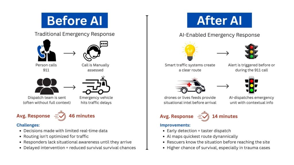
    Here’s why that model is collapsing under pressure:

    1. Delayed Decision-Making in a High-Stakes Window

    Every emergency has a golden hour—a short window when intervention can dramatically increase survival rates. According to a study published in BMJ Open, a delay of even 5 minutes in ambulance arrival is associated with a 10% decrease in survival rate in cases like cardiac arrest or major trauma.

    But that’s what’s happening—because the system depends on humans making snap decisions with incomplete or outdated information. And while responders are trained, they’re not clairvoyants.

    2. One Size Fits None: Poor Resource Allocation

    A report by McKinsey & Company found that over 20% of emergency deployments in urban areas were either over-responded or under-resourced, often due to dispatchers lacking real-time visibility into resource availability or incident severity.

    That’s not just inefficient—it’s dangerous.

    3. Siloed Systems = Slower Reactions

    Police, fire, EMS—even weather and utility teams—operate on different digital platforms. In a disaster, that means manual handoffs, missed updates, or even duplicate efforts.

    And in events like hurricanes, chemical spills, or industrial fires, inter-agency coordination isn’t optional—it’s survival.

    A case study from Houston’s response to Hurricane Harvey found that agencies using interoperable data-sharing platforms responded 40% faster than those using siloed systems.

    Real-Time Data and AI: Your Digital First Responders

    Now imagine a different model—one that doesn’t wait for a call. One that acts the moment data shows a red flag.

    We’re talking about real-time data, gathered from dozens of touchpoints across your environment—and processed instantly by AI systems.

    But before we dive into what AI does, let’s first understand where this data comes from.

    Traditional data systems tell you what just happened.

    Predictive analytics powered by AI tells you what’s about to happen, offering reliable methods to predict natural disasters in real-time.

    And that gives responders something they’ve never had before: lead time.

    Let’s break it down:

    • Machine learning models, trained on thousands of past incidents, can identify the early signs of a wildfire before a human even notices smoke.
    • In flood-prone cities, predictive AI now uses rainfall, soil absorption, and river flow data to estimate overflow risks hours in advance. Such forecasting techniques are among the most effective methods to predict natural disasters like flash floods and landslides.
    • Some 911 centers now use natural language processing to analyze caller voice patterns, tone, and choice of words to detect hidden signs of a heart attack or panic disorder—often before the patient is even aware.

    What Exactly Is AI Doing in Emergencies?

    Think of AI as your 24/7 digital analyst that never sleeps. It does the hard work behind the scenes—sorting through mountains of data to find the one insight that saves lives.

    Here’s how AI is helping:

    • Spotting patterns before humans can: Whether it’s the early signs of a wildfire or crowd movement indicating a possible riot, AI detects red flags fast.
    • Predicting disasters: With enough historical and environmental data, AI applies advanced methods to predict natural disasters such as floods, earthquakes, and infrastructure collapse.
    • Understanding voice and language: Natural Language Processing (NLP) helps AI interpret 911 calls, tweets, and distress messages in real time—even identifying keywords like “gunshot,” “collapsed,” or “help.”
    • Interpreting images and video: Computer vision lets drones and cameras analyze real-time visuals—detecting injuries, structural damage, or fire spread.
    • Recommending actions instantly: Based on location, severity, and available resources, AI can recommend the best emergency response route in seconds.

    What Happens When AI Takes the Lead in Emergencies

    Let’s walk through real-world examples that show how this tech is actively saving lives, cutting costs, and changing how we prepare for disasters.

    But more importantly, let’s understand why these wins matter—and what they reveal about the future of emergency management.

    1. AI-powered Dispatch Cuts Response Time by 70%

    In Fremont, California, officials implemented a smart traffic management system powered by real-time data and AI. Here’s what it does: it pulls live input from GPS, traffic lights, and cameras—and automatically clears routes for emergency vehicles.

    Result? Average ambulance travel time dropped from 46 minutes to just 14 minutes.

    Why it matters: This isn’t just faster—it’s life-saving. The American Heart Association notes that survival drops by 7-10% for every minute delay in treating cardiac arrest. AI routing means minutes reclaimed = lives saved.

    It also means fewer traffic accidents involving emergency vehicles—a cost-saving and safety win.

    2. Predicting Wildfires Before They Spread

    NASA and IBM teamed up to build AI tools that analyze satellite data, terrain elevation, and meteorological patterns—pioneering new methods to predict natural disasters like wildfire spread. These models detect subtle signs—like vegetation dryness and wind shifts, well before a human observer could act.

    Authorities now get alerts hours or even days before the fires reach populated zones.

    Why it matters: Early detection means time to evacuate, mobilize resources, and prevent large-scale destruction. And as climate change pushes wildfire frequency higher, predictive tools like this could be the frontline defense in vulnerable regions like California, Greece, and Australia.

    3. Using Drones to Save Survivors

    The Robotics Institute at Carnegie Mellon University built autonomous drones that scan disaster zones using thermal imaging, AI-based shape recognition, and 3D mapping.

    These drones detect human forms under rubble, assess structural damage, and map the safest access routes—all without risking responder lives.

    Why it matters: In disasters like earthquakes or building collapses, every second counts—and so does responder safety. Autonomous aerial support means faster search and rescue, especially in areas unsafe for human entry.

    This also reduces search costs and prevents secondary injuries to rescue personnel.

    What all these applications have in common:

    • They don’t wait for a 911 call.
    • They reduce dependency on guesswork.
    • They turn data into decisions—instantly.

    These aren’t isolated wins. They signal a shift toward intelligent infrastructure, where public safety is proactive, not reactive.

    Why This Tech is Essential for Your Organization?

    Understanding and applying modern methods to predict natural disasters is no longer optional—it’s a strategic advantage. Whether you’re in public safety, municipal planning, disaster management, or healthcare, this shift toward AI-enhanced emergency response offers major wins:

    • Faster response times: The right help reaches the right place—instantly.
    • Fewer false alarms: AI helps distinguish serious emergencies from minor incidents.
    • Better coordination: Connected systems allow fire, EMS, and police to work from the same real-time playbook.
    • More lives saved: Ultimately, everything leads to fewer injuries, less damage, and more lives protected.

    If so, Where Do You Start?

    You don’t have to reinvent the wheel. But you do need to modernize how you respond to crises. And that starts with a strategy:

    1. Assess your current response tech: Are your systems integrated? Can they talk to each other in real time?
    2. Explore data sources: What real-time data can you tap into—IoT, social media, GIS, wearables?
    3. Partner with the right experts: You need a team that understands AI, knows public safety, and can integrate solutions seamlessly.

    Final Thought

    Emergencies will always demand fast action. But in today’s world, speed alone isn’t enough—you need systems built on proven methods to predict natural disasters, allowing them to anticipate, adapt, and act before the crisis escalates.

    This is where data steps in. And when combined with AI, it transforms emergency response from a reactive scramble to a coordinated, intelligent operation.

    The siren still matters. But now, it’s backed by a brain—a system quietly working behind the scenes to reroute traffic, flag danger, alert responders, and even predict the next move.

    At SCS Tech India, we help forward-thinking organizations turn that possibility into reality. Whether it’s AI-powered dispatch, predictive analytics, or drone-assisted search and rescue—we build custom solutions that turn seconds into lifesavers.

    Because in an emergency, every moment counts. And with the right technology, you won’t just respond faster. You’ll respond smarter.

    FAQs

    What kind of data should we start collecting right now to prepare for AI deployment in the future?

    Start with what’s already within reach:

    • Response times (from dispatch to on-site arrival)
    • Resource logs (who was sent, where, and how many)
    • Incident types and outcomes
    • Environmental factors (location, time of day, traffic patterns)

    This foundational data helps build patterns. The more consistent and clean your data, the more accurate and useful your AI models will be later. Don’t wait for the “perfect platform” to start collecting—it’s the habit of logging that pays off.

    Will AI replace human decision-making in emergencies?

    No—and it shouldn’t. AI augments, not replaces. What it does is compress time: surfacing the right information, highlighting anomalies, recommending actions—all faster than a human ever could. But the final decision still rests with the trained responder. Think of AI as your co-pilot, not your replacement.

    How can we ensure data privacy and security when using real-time AI systems?

    Great question—and a critical one. The systems you deploy must adhere to:

    • End-to-end encryption for data in transit
    • Role-based access for sensitive information
    • Audit trails to monitor every data interaction
    • Compliance with local and global regulations (HIPAA, GDPR, etc.)

    Also, work with vendors who build privacy into the architecture—not as an afterthought. Transparency in how data is used, stored, and trained is non-negotiable when lives and trust are on the line.

  • How GIS Companies in India Use Satellites and Drones to Improve Land Records & Property Management?

    How GIS Companies in India Use Satellites and Drones to Improve Land Records & Property Management?

    India, occupying just 2.4% of the world’s entire land area, accommodates 18% of the world’s population, resulting in congested land resources, high-speed urbanization, and loss of productive land. For sustainable land management, reliable land records, effective land use planning, and better property management are essential.

    To meet the demand, Geographic Information System (GIS) companies use satellite technology and drones to establish precise, transparent, and current land records while facilitating effective property management. The latest technologies are revolutionizing land surveying, cadastral mapping, property valuation, and land administration, enhancing decision-making immensely.

    This in-depth blog discussion addresses all steps involved in how GIS companies in India utilize satellites and drones to improve land records and property management.

    How Satellite Technology is Used in Land Records & Property Management

    Satellite imagery is the foundation of contemporary land management, as it allows for exact documentation, analysis, and tracking of land lots over massive regions. In contrast to error-prone, time-consuming ground surveys, satellite-based land mapping provides high-scale, real-time, and highly accurate knowledge.

    how satellite technology aids land records management

    The principal benefits of employing satellites in land records management are:

    • Extensive Coverage: Satellites can simultaneously cover entire states or the whole nation, enabling mass-scale mapping.
    • Availability of Historical Data: Satellite images taken decades ago enable monitoring of land-use patterns over decades, facilitating settlement of disputes relating to ownership.
    • Accessibility from Remote Locations: No requirement for physical field visits; the authorities can evaluate land even from remote areas.

    1. Cadastral Mapping – Determining Accurate Property Boundaries

    Cadastral maps are the legal basis for property ownership. Traditionally, they were manually drafted, with the result that they contained errors, boundary overlap, and owner disputes. Employing satellite imaging, GIS companies in India can now:

    • Map land parcels digitally, depicting boundaries accurately.
    • Cross-check land titles by layering historical data over satellite-derived cadastral data.
    • Identify encroachments by matching old records against new high-resolution imagery.

    For example, a landowner asserting additional land outside their legal boundary can be easily located using satellite-based cadastral mapping, assisting local authorities in correcting such instances.

    2. Land Use and Land Cover Classification (LULC)

    Land use classification is essential for urban, conservation, and infrastructure planning. GIS companies in India examine satellite images to classify land, including:

    • Agricultural land
    • Forests and protected areas
    • Residential, commercial, and industrial areas
    • Water bodies and wetlands
    • Barren land

    Such a classification aids the government in regulating zoning laws, tracking illegal land conversions, and enforcing environmental rules.

    For instance, the illegal conversion of agricultural land into residential areas can be easily identified using satellite imagery, allowing regulatory agencies to act against unlawful real estate development simultaneously.

    3. Automated Change Detection – Tracking Illegal Construction & Encroachments

    One of the biggest challenges in land administration is the proliferation of illegal constructions and unauthorized encroachments. Satellite-based GIS systems offer automated change detection, wherein:

    • Regular satellite scans detect new structures that do not match approved plans.
    • Illegal mining, deforestation, or land encroachments are flagged in real-time.
    • Land conversion violations (e.g., illegally converting wetlands into commercial zones) are automatically reported to authorities.

    For example, a satellite monitoring system identified the unauthorized expansion of a residential colony into government land in Rajasthan, which prompted timely action and legal proceedings.

    4. Satellite-Based Property Taxation & Valuation

    Correct property valuation is critical for equitable taxation and the generation of revenues. Property valuation traditionally depended on physical surveys, but satellites have made it a streamlined process:

    • Location-based appraisal: Distance to highways, commercial centers, and infrastructure developments is included in the tax calculation.
    • Footprint building analysis: Machine learning-based satellite imaging calculates covered areas, avoiding tax evasion.
    • Market trend comparison: Satellite photos and property sale data enable the government to levy property taxes equitably.

    For example, the municipal government in Bangalore utilized satellite images to spot almost 30,000 properties that had not been appropriately reported in tax returns, and the property tax revenue went up.

    How Drone Technology is Applied to Land Surveys & Property Management

    While satellites give macro-level information, drones collect high-accuracy, real-time, and localized data. Drones are indispensable in regions where extreme precision is required, such as:

    • Urban land surveys with millimeter-level accuracy.
    • Land disputes demanding legally admissible cadastral records.
    • Surveying terrain in hilly, forested, or inaccessible areas.
    • Rural land mapping under government schemes such as SVAMITVA.

    1. Drone-Based Cadastral Mapping & Land Surveys

    Drones with LiDAR sensors, high-resolution cameras, and GPS technology undertake automated cadastral surveys, allowing:

    • Accurate land boundary mapping, dispelling disputes.
    • Faster surveying (weeks rather than months), cutting down administrative delays.
    • Low-cost operations compared to conventional surveying.

    For example, drones are being employed to map rural land digitally under the SVAMITVA Scheme, issuing official property titles to millions of landholders.

    2. 3D Modeling for Urban & Infrastructure Planning

    Drones produce precise 3D maps that offer:

    • Correct visualization of cityscapes for planning infrastructure projects.
    • Topography models that facilitate flood control and disaster management.
    • Better land valuation insights based on elevation, terrain, and proximity to amenities.

    For example, Mumbai’s urban planning department used drone-based 3D mapping to assess redevelopment projects, ensuring efficient use of land resources.

    3. AI-Powered Analysis of Drone Data

    Modern GIS software integrates Artificial Intelligence (AI) and Machine Learning (ML) to:

    • Detect unauthorized construction automatically.
    • Analyze terrain data for thoughtful city planning.
    • Classify land parcels for taxation and valuation purposes.

    For instance, a Hyderabad-based drone-based AI system identified illegal constructions and ensured compliance with urban planning regulations.

    Integration of GIS, Satellites & Drones into Land Information Systems

    Satellite and drone data are integrated into Intelligent Land Information Systems (ILIS) by GIS companies in India that encompass:

    A. System of Record (Digital Land Registry)

    • Geospatial database correlating land ownership, taxation, and legal titles.
    • Blockchain-based digital land records resistant to tampering.
    • Uninterrupted connectivity with legal and financial organizations.

    B. System of Insight (Automated Land Valuation & Analytics)

    • Artificial intelligence-based property valuation models based on geography, land topology, and urbanization.
    • Automated taxation ensures equitable revenue collection.

    C. System of Engagement (Public Access & Governance)

    • Internet-based GIS portals enable citizens to confirm property ownership electronically.
    • Live dashboards monitor land transactions, conflicts, and valuation patterns.

    Conclusion

    GIS, satellite imagery, and drones have transformed India’s land records and property management by making accurate mapping, real-time tracking, and valuation efficient. Satellites give high-level insights, while drones provide high-precision surveys, lowering conflicts and enhancing taxation.

    GIS companies in India like SCS Tech, with their high-end GIS strength, facilitate such data-based land administration, propelling India towards a transparent, efficient, and digitally integrated system of governance, guaranteeing equitable property rights, sustainable planning, and economic development.

  • How Do Digital Oilfields Improve Oil and Gas Technology Solutions?

    How Do Digital Oilfields Improve Oil and Gas Technology Solutions?

    Are you aware of the oil and gas technology that is transforming the industry? There’s an operation so bright that it reduces costs by 25%, increases production rates by 4%, and enhances recovery by 7%, all within just a few years. This is, says CERA, the actual effect of applying digital oilfield technologies. The digital oilfield applies advanced tools to transform oilfield operations’ efficiency, cost-effectiveness, and sustainability.

    Read further to understand how digital oilfields change oil and gas industry solutions.

    What Are Digital Oilfields?

    Digital oilfields are a technological revolution in oil and gas operations. Using IoT, AI, and ML, they make processes more efficient and cost-effective and provide better decision-making capabilities. From real-time data collection to advanced analytics and automation, digital oilfields integrate every operational aspect into a seamless, optimized ecosystem.

    Key Components of Digital Oilfields

    1. Data Gathering and Surveillance

    Digital oilfields start with collecting enormous volumes of real-time data:

    • IoT Sensors: Scattered across drilling locations, these sensors track pressure, temperature, flow rates, and equipment status. For instance, sudden changes in sound pressure may alert operators to take corrective actions immediately.
    • Remote Monitoring: Operators can control geographically dispersed assets from centralized control rooms or remote locations. Telemetry systems ensure smooth data transmission for quick decision-making.
    1. Advanced Analytics

    The gathered data is processed and analyzed for actionable insights:

    • Machine Learning and AI: Predictive AI analytics identifies possible equipment failures and optimizes the maintenance schedule. For example, an AI system can predict when a pump will fail so proactive maintenance can be scheduled.
    • Data Integration: Advanced analytics combines geological surveys, production logs, and market trends to give a holistic view, which is helpful in strategic decisions.
    1. Automation

    Automation minimizes human intervention in repetitive tasks:

    • Automated Workflows: Drill rigs do real-time optimizations depending on sensor feedback to improve performance and reduce errors.
    • Robotics and Remote Operations: Robotics and ROVs execute tasks like underwater surveys, which can be executed safely without losing efficiency.
    1. Collaboration Tools

    Digital Oilfield streamlines communication and Teamwork.

    • Integrated Communication Platforms: Real-time information sharing between the teams, video conferencing tools, and centralized platforms facilitate efficient collaboration.
    • Cloud-Based Solutions: Geologists, engineers, and managers can access data from anywhere, which leads to better coordination.
    1. Visualization Technologies

    Visualization tools turn data into actionable insights:

    • Dashboards: KPIs are displayed in digestible formats, which enables operators to spot and address issues quickly.
    • Digital Twins: Virtual replicas of the physical assets enable simulations, which allow operators to test scenarios and implement improvements without risking real-world operations.

    How Digital Oilfields Improve Oil and Gas Technology Solutions

    Digital oilfields utilize modern technologies to make the oil and gas technology solutions operational landscape more efficient. This results in efficiency, improved safety, cost-effectiveness, and optimized production with better sustainability. The explanation below elaborates on how digital oilfields enhance technology solutions in the oil and gas industry.

    1. Improved Operative Efficiency

    Digital oilfields improve operational efficiency through the following:

    • Real-Time Data Monitoring: IoT sensors deployed across oilfield assets such as wells, pipelines, and drilling rigs collect real-time data on various parameters (pressure, temperature, flow rates). This data is transmitted to centralized systems for immediate analysis, allowing operators to detect anomalies quickly and optimize operations accordingly.
    • Predictive Maintenance: With the help of AI and machine learning algorithms, the digital oilfield can predict equipment failures before they happen. For instance, Shell’s predictive maintenance has resulted in a timely intervention that saves the company from costly downtimes. These systems could predict when maintenance should be performed based on historical performance data and current operating conditions by extending equipment lifespan and reducing operational interruptions.
    • Workflow Automation: Technologies automate workflow and reduce people’s manual interfaces with routine items like equipment checking and data typing, which conserve time and lead to fewer possible errors. Example: an automated system for drilling optimizes the entire process as sensors provide feedback from which it sets parameters for continuous drilling in the well.

    2. Improved Reservoir Management

    Digital oilfields add to reservoir management with superior analytical techniques.

    • AI-Driven Reservoir Modeling: Digital oilfields utilize high-end AI models to analyze geology data to predict the reservoir’s behavior. These models can provide insight into subsurface conditions, enabling better decisions about the location of a well and the method of extraction for operators. Thus, it makes hydrocarbon recovery more efficient while reducing the environmental footprint.
    • Improve Recovery Techniques: With a better characterization of reservoirs, these digital oilfields are set up to implement enhanced oil recovery techniques suited for specific reservoir conditions. For instance, real-time data analytics can allow data-driven optimization techniques in water flooding or gas injection strategies to recover maximum amounts.

    3. Cost Cut

    The financial benefits of digital oilfields are tremendous:

    • Lower Capital Expenditures: Companies can avoid the high costs of maintaining on-premises data centers by using cloud computing for data storage and processing. This shift allows for scalable operations without significant upfront investment.
    • Operational Cost Savings: Digital technologies have shown a high ROI by bringing down capital and operating expenses. For instance, automating mundane activities will reduce labor costs but enhance production quantity. According to research, companies have seen an operative cost reduction of as much as 25% within the first year after deploying digital solutions.

    4. Improved Production Rates

    Digital oilfields increase production rates through:

    • Optimized Drilling Operations: Real-time analytics allow operators to adjust drilling parameters based on immediate feedback from sensors dynamically. This capability helps avoid issues such as drill bit wear or unexpected geological formations that can slow down operations.
    • Data-Driven Decision Making: With big data analytics, companies can quickly process vast volumes of operational data. These analyses underpin strategic decisions to improve production performance along the value chain from exploration through extraction.

    5. Sustainability Benefits

    Digital oilfield technologies are essential contributors to sustainability.

    • Environmental Monitoring: Modern monitoring systems can sense the leakage or emission, enabling solutions to be implemented immediately. AI-based advanced predictive analytics can identify where environmental risk has the potential to arise before it becomes a significant problem.
    • Resource Optimization: Digital oilfields optimize resource extraction processes and minimize waste; this process reduces the ecological footprint of oil production. For example, optimized energy management practices reduce energy consumption during extraction processes.

    6. Improved Safety Standards

    Safety is improved through various digital technologies:

    • Remote Operations: Digital oilfields allow for the remote monitoring and control of operations, thus allowing less personnel exposure to hazardous conditions. This enables one to reduce exposure to risks associated with drilling activities.
    • Wearable Technology: Wearable devices equipped with biosensors enable real-time monitoring of workers in the field and their health status. The wearable devices can notify the management of a potential health risk or unsafe conditions that may cause an accident.

    Conclusion

    The digital oilfield is a revolutionary innovation introduced into the oil and gas industry, combining the latest technologies to improve operational efficiency, better manage a reservoir, cut costs, enhance production rates, foster sustainability, and raise safety levels. The comprehensive implementation of IoT sensors, AI-driven analytics, automated tools, and cloud computing not only optimizes existing operations but projects an industry toward a position of success for future challenges.

    As digital transformation continues to unfold within this sector, the implications for efficiency and sustainability will grow more profoundly. SCS Tech, with its expertise in advanced oil and gas technology solutions, stands as a trusted partner in enabling this transformation and helping businesses embrace the potential of digital oilfield technologies.

  • How E-Governance Solutions Are Enhancing Citizen Participation?

    How E-Governance Solutions Are Enhancing Citizen Participation?

    Have you noticed how technology changes how governments engage with citizens? E-governance solutions are no longer a buzzword but a movement rewriting the governance rules. From speeding up social benefit transfers, innovations such as DBT systems have sparked a 192% surge in efficiency. Such advancements make governance more innovative, inclusive, and genuinely citizen-centric.

    In this blog, let’s explore how e-governance solutions, powered by advancements in AI and robust IT infrastructure, are transforming governance. These solutions incorporate active citizen participation in administration, making public services more responsive.

    How E-Governance Solutions Are Enhancing Citizen Participation?

    E-Governance boosting citizen participation
    E-Governance boosting citizen participation

    1. Digital Platform for Communication

    One of the cornerstones of e-governance is utilizing a digital platform to bring governance closer to citizens. There are real-time engagements such that citizens are constantly and regularly informed and involved with the government:

    • Web Portals and Mobile Apps: These digital gateways provide instant access to services like bill payments, license applications, and complaint registrations. Citizens do not have to visit government offices to carry out these tasks, saving them time and effort. With mobile apps, users are provided with user-friendly interfaces through which they can register complaints, access public schemes, and get updates.
    • Social Media: It is the platform through which two-way communication takes place. Platforms include Twitter, Facebook, and Instagram. Governments can inform citizens about policies, events, and public initiatives at a very fast pace, and the citizens can voice their concerns and give feedback. Through social media, governments can keep track of public opinion and respond to concerns immediately.

    These digital platforms make interaction easier and make governance more accessible and inclusive. They bridge the gap between government agencies and citizens, ensuring that everyone, regardless of location, can stay connected.

    2. E-Participation Tools

    E-governance goes beyond one-way communication by actively involving citizens in decision-making through participatory tools.

    • Online Surveys and Polls: Governments conduct surveys to gather public opinions on new policies, projects, or initiatives. This direct feedback allows decision-makers to align policies with citizen needs and preferences. For example, before launching a new law, authorities can gauge its acceptance through online polls.
    • Discussion Forums: Structured forums provide avenues for citizens to discuss and deliberate on policy issues. Such avenues allow informed participation, so that people may share their ideas, develop solutions collectively, and input into shaping community projects.
    • Crowdsourcing Programs: The government invites citizens to submit innovative ideas or solutions for public challenges. This makes them feel owned and included. For instance, citizens can suggest improvements in infrastructure, education, or health systems through specific crowdsourcing platforms.

    These tools empower citizens to take an active role in governance, ensuring that policies reflect diverse voices and community needs.

    3. Data Transparency and Accessibility

    Building Trust is founded on transparency and e-governance creates solutions for providing the public sector operations much more transparent and accountable.

    • Open Data Portals: This allows citizens to explore the available data regarding budgets, projects, and expenses. Analyzing this information can help explain to people how funds for public services are allocated and utilized, holding authorities accountable.
    • Real-Time Tracking Systems: These allow citizens to keep track of how their applications, complaints, or government services are being carried out. A citizen could apply for welfare benefits or a building permit – the status could be kept online, eliminating frustration or uncertainty.

    Transparency through such tools will not only create trust but also enhance citizens’ ability to be more actively involved in governance processes. People’s participation is meaningful when they can see the processes of decision-making as well as resource allocation.

    How E-Governance Solutions for Improved Public Sector Efficiency?

    The new solutions for e-governance redefine the delivery of services within the public sector, relying on Information Technology (IT), then Information and Communication Technologies (ICTs), and web-based platforms to facilitate effective, transparent, and accessible governance. Whether it is health or transportation, urban development, or utilities, these new solutions are changing the experience of governance for citizens.

    Integrated Services through Centralized Systems

    One of the key features of e-governance is that it combines various government services on a single platform. Such centralized systems allow for:

    • Streamlined Service Delivery: Citizens can file taxes, apply for permits, and enroll in benefits from a single portal.
    • Improved Interdepartmental Coordination: Data sharing across departments results in faster responses and reduced redundancy.
    • User-Centric Design: Easy-to-use interfaces make it easier for people to find and use services.

    For instance, an integrated platform may offer the facility to pay property tax, lodge a complaint, and obtain a driving license in one place.

    Automated Document Processes

    The olden days of paperwork, along with electronic documents and workflow management, are long gone. Such software programs automate the document handling and approval process, and therefore lead to the following:

    • Quick Delivery of Services: Service delivery happens fast without being hindered by the time-consuming nature of manual processes.
    • Less Human Errors: Automated workflows help minimize human errors.
    • More Accurate Record Keeping: Digital records promote more accountability and easy accessibility for later use.

    These automations mean real-time benefits to citizens in terms of waiting time to receive permits or certification, for example.

    Safe and Smart City Solutions

    Governments are using the IoT (Internet of Things) and AI to create better cities. These solutions benefit by:

    • Optimized Resource Allocation: Smart sensors monitor traffic, energy use, and safety metrics in real-time.
    • Proactive Services: AI-powered analytics predict service demands, such as waste collection schedules or public transport requirements.
    • Improved Safety: IoT-enabled surveillance systems and emergency response tools create safer communities.

    For instance, smart traffic management systems can reduce congestion while improving road safety for citizens.

    Conclusion

    E-governance solutions change governance by making the processes more transparent, effective, and participatory. They can enhance service delivery and citizen involvement by incorporating AI technologies into IT infrastructure solutions. Then, problems like the digital divide and data privacy exist for these solutions to be fully exploited.

    E-government, therefore, helps governments achieve a strong democracy, build up trust, and empower their citizens to take an active role in shaping their surroundings. The future of governance is easy: inclusivity, adaptability, and true people-serving technology solutions. This change provides a backdrop for an enabling force like SCS Tech, offering cutting-edge IT infrastructure solutions that make this novel development possible.

  • IoT the next big thing or already is? In perspective of Industry 4.O

    IoT the next big thing or already is? In perspective of Industry 4.O

    One of the key technology foundations of Industry 4.0 is the Internet of Things. The ability of machines to independently communicate with one another allows them to solve issues that would previously require human intervention.

    It is anticipated that the use of industrial IoT for predictive maintenance and a rise in the number of data centres would present sizable market expansion prospects. Additionally, the government’s promotion of industrial automation and the demand for high productivity & efficiency are the main factors propelling the growth of this market.

    The majority of firms have acquired a high degree of IoT maturity, and through 2024, enterprises from all industry sectors intend to invest an average of $2.8 million in IoT. Businesses anticipate spending 10% of their IT budgets on IoT initiatives during the next three years, up from the average 7% of an organization’s IT expenditure between 2017 and 2020.

    However, there are observable differences in the expected IoT investment levels across various business sectors. Over the next three years, oil and gas companies plan to invest the most in IoT ($3.2 million on average), followed by electrical utilities ($3.1 million), transportation and logistics ($3 million), mining operators ($2.7 million), and finally, agricultural industries ($2 million).

    Latest research conducted by Inmarsat Enterprise reveals IoT is now the primary Industry 4.0 technology in which companies are investing over the next three years. IoT is becoming a company investment priority, and businesses expect it to save them an increasing amount of money in the next years. This shows how well-established an industry IoT has become globally. Despite the fact that IoT adoption is already accelerating quickly, Covid-19 has stressed the value of Industry 4.0 technologies like IoT for maintaining business continuity. Companies who create digital twins of their supply chains and share data are reaping the rewards as the world’s manufacturing and supply chains become more integrated and digitalized.

    In the Indian Landscape –

    India is a hive of IoT provider potential, and the nation’s IoT ecosystem is anticipated to keep expanding to generate entirely new sources of income. To stay ahead of the curve and meet the growing demand for IoT solutions, vendors should collaborate with other members of the value ecosystem to take advantage of cutting-edge technologies like Big Data analytics, AI and machine learning, new connectivity protocols, and blockchain.

    Private long-term evolution for improved security: Indian tech organizations should concentrate on promoting the advantages of P-LTE to raise awareness and approach businesses with solutions tailored to specific verticals.

    Real-time operational intelligence for improved risk and compliance management: To deliver brand-neutral IoT solutions, suppliers must create hardware and software that is interoperable and pre-integrated.

    Visual matrix solutions for better CX: IoT providers should collaborate with OEMs of visual surveillance systems to offer in-store, real-time consumer analytics in addition to core security solutions.

    IoT as a Service for Smart Diagnostic Laboratories: By starting with open source IoT solutions, expenses can be significantly cut, which will promote the use of smart laboratories as a service.

    By using our global knowledge and top-class IoT solutions, we can assist your business with our digital transformation and automation services. If you’re looking for understanding partners which can deliver results, contact us now.

  • How technology is making our everyday better

    How technology is making our everyday better

    All technologies that have emerged and thrived thus far have been invented to meet the needs of society, as it is rightly said that necessity is the mother of invention. Without a doubt, technology has made our lives easier over the last two decades. Technology has made our lives better in a number of ways, from communicating with people around the world from the convenience of your home to operating a full-fledged business without a physical site.

    We live in a capitalist society, which means that many technological advances are made by businesses looking to improve their products/services or their ability to market their offerings. Over the years, new technology has emerged with the goal of making business operations more beneficial and effective.

    Business Efficiency

    The business world is being swept away by a tidal wave of exponential technological progress. Today’s marketplace provides numerous opportunities to improve, adapt, and advance using available technology. The use of business analytics has proven to be beneficial in improving the customer experience. Such technology-powered business tools have propelled various aspects of business to new heights. Personalized messaging and user behavior analysis have also assisted businesses in establishing a fruitful presence in the market.

    Fast track Communication

    The only certain answer to how technology has improved our lives is that it has changed the way we communicate with one another dramatically. It has resulted in the development of several modes of electronic communication, including smartphone communication and social media. Now that civilization has advanced, instantaneous, error-free communication is widely accessible. Speed is undeniably the most significant advancement that technology has made in communication. We can now converse quickly and effortlessly from the convenience of our homes.

    Advanced Lifestyle

    Throughout history, societies have been reshaped by technology. Technology has had a significant impact on how humans behave and operate in the world. Technological advancements all around us are ongoing. New innovations are appearing, and they are undoubtedly influencing our way of life. Because of technological advancements, our lives are now vastly different from those of previous generations Transportation, agriculture, and education are just a few areas where technology is present and having an impact. On the other hand, the Internet of Things (IoT) has greatly simplified our lives. Through the medium of IoT, smart homes and advanced electronic gadgets have significantly improved our daily routines. It has simplified many aspects of life.

    Superior Trade

    Transactions are much simpler and more efficient than they were previously. On the consumer side, innovations such as the credit card and the rise of e-commerce have made it easier than ever for businesses to sell goods and services to customers at their leisure. However, transactions on a large scale are much easier on a B2B level. Foreign transactions like these are now much easier – and they may become even easier as blockchain, an emerging technology, gains traction.

    Information Accessibility

    Technology has had a significant impact on how we transfer and access information. Nowadays, we can get any information we want at the touch of a button. We are constantly searching the internet for answers and gathering information. If one learns how to surf more skillfully, technology is readily available to us, both in terms of authenticity and relevancy.

    We’ve gotten to the point where it’s difficult to imagine life without technology. The quality of life for people has considerably increased. Technology has altered our behavior and operations by infiltrating every aspect of our lives. Technology has made our lives better in a number of areas, including networking, healthcare, and communication.