For business owners, preparing for natural disasters is paramount to safeguarding their operations and employees. That’s where Geographic Information Systems (GIS) come into play.
In this blog, we’ll explore how geographical information system software, especially the solutions offered by companies in India, plays a vital role in disaster management. It provides invaluable support, from predicting where disasters might strike to guiding emergency responses.
Join us as we uncover how GIS can empower businesses to protect their assets and ensure continuity during natural calamities.
Understanding GIS and Its Applications in Natural Disaster Management
Natural disasters can have devastating effects on communities and businesses alike. However, geographical information system software offers a powerful tool set to help mitigate these risks and manage the aftermath more effectively.
What is GIS?
At its core, GIS is a technology that captures, analyzes, and presents spatial or geographical data. This includes information such as maps, satellite imagery, and geographic coordinates.
Applications in Disaster Management
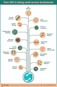
GIS plays a crucial role in various stages of disaster management:
- Prevention and Preparedness: Geographical information system software helps authorities identify risks and develop mitigation strategies by mapping potential hazards, vulnerable areas, and critical infrastructure. For example, it can be used to map flood zones, earthquake fault lines, and areas prone to wildfires.
- Response and Relief: it enables real-time monitoring and coordination of response efforts during a disaster. Emergency responders can use GIS to track the movement of a hurricane, identify affected areas, and deploy resources where needed most. GIS also helps establish temporary shelters, evacuation routes, and medical facilities.
- Recovery and Reconstruction: After the disaster has passed, it plays a vital role in assessing damages and planning reconstruction efforts. By mapping out the extent of destruction, it helps prioritize areas for recovery and allocate resources effectively. Additionally, it aids in monitoring environmental impacts, such as soil erosion or pollution, and planning restoration projects.
GIS Methods to Predict Natural Disasters
GIS technology is crucial in predicting and forecasting and in natural disaster management, enabling proactive decision-making and resource allocation.
- Remote Sensing and Satellite Imagery: geographical information system software utilizes satellite imagery to monitor environmental changes and indicators of impending disasters.
- Modelling and Simulation: it models analyze historical data and environmental factors to forecast hurricanes, floods, and landslides.
- Early Warning Systems: it integrates real-time data to develop early warning systems for timely alerts and proactive measures.
Real-Time Monitoring and Response with GIS
Timely response to natural disasters is critical for minimizing damage and saving lives. GIS technology enables real-time monitoring and coordinated response efforts.
- Data Integration: GIS platforms integrate real-time data from various sources, providing up-to-date insights into evolving disaster scenarios.
- Situational Awareness: it visualizes critical information on interactive maps, enhancing situational awareness for emergency response teams.
- Resource Allocation: it helps prioritize response efforts by efficiently identifying areas at the most significant risk and allocating resources.
- Coordination: it facilitates collaboration among multiple agencies, ensuring a unified and effective disaster response.
GIS Companies in India: Leading in Disaster Management
India boasts several GIS companies specializing in disaster management solutions. These companies offer tailored expertise and innovative technologies to effectively predict, monitor, and respond to natural disasters management.
- Expert Solutions: GIS companies in India provide cutting-edge solutions for flood mapping, landslide prediction, and more, enhancing disaster resilience.
- Government Collaboration: They collaborate closely with government agencies, integrating GIS into disaster management frameworks to streamline response efforts.
- Capacity Building: These companies offer training programs to equip officials and responders with GIS skills, empowering communities to mitigate disaster impact.
- Community Engagement: Through outreach programs, they raise awareness and promote preparedness measures among local communities.
- Innovation: These companies are leaders in innovation. They invest in research to develop new disaster prediction and response technologies.
Conclusion
In conclusion, geographical information system software(GIS) play a pivotal role in every phase of disaster management, from prediction to recovery. Through advanced technologies and innovative solutions, GIS empowers communities and authorities to anticipate, monitor, and respond to natural disasters precisely and efficiently. GIS companies in India are at the forefront of this effort in India, offering expertise, solutions, and collaboration to enhance disaster resilience nationwide.
As businesses navigate the complexities of disaster management, leveraging GIS technology becomes increasingly essential. By partnering with GIS companies in India and embracing innovative solutions, businesses can strengthen their disaster preparedness, protect their assets, and contribute to the safety and well-being of their communities.
Visit SCS Tech India’s website today to explore how its GIS solutions can support your disaster management initiatives.
Together, let us harness the power of GIS to build a safer, more resilient future for all.