Tag: Geospatial information system

  • How GIS Companies in India Use Satellites and Drones to Improve Land Records & Property Management?

    How GIS Companies in India Use Satellites and Drones to Improve Land Records & Property Management?

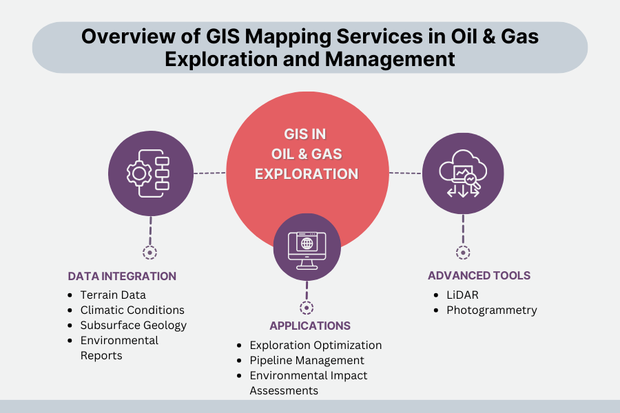
    India, occupying just 2.4% of the world’s entire land area, accommodates 18% of the world’s population, resulting in congested land resources, high-speed urbanization, and loss of productive land. For sustainable land management, reliable land records, effective land use planning, and better property management are essential.

    To meet the demand, Geographic Information System (GIS) companies use satellite technology and drones to establish precise, transparent, and current land records while facilitating effective property management. The latest technologies are revolutionizing land surveying, cadastral mapping, property valuation, and land administration, enhancing decision-making immensely.

    This in-depth blog discussion addresses all steps involved in how GIS companies in India utilize satellites and drones to improve land records and property management.

    How Satellite Technology is Used in Land Records & Property Management

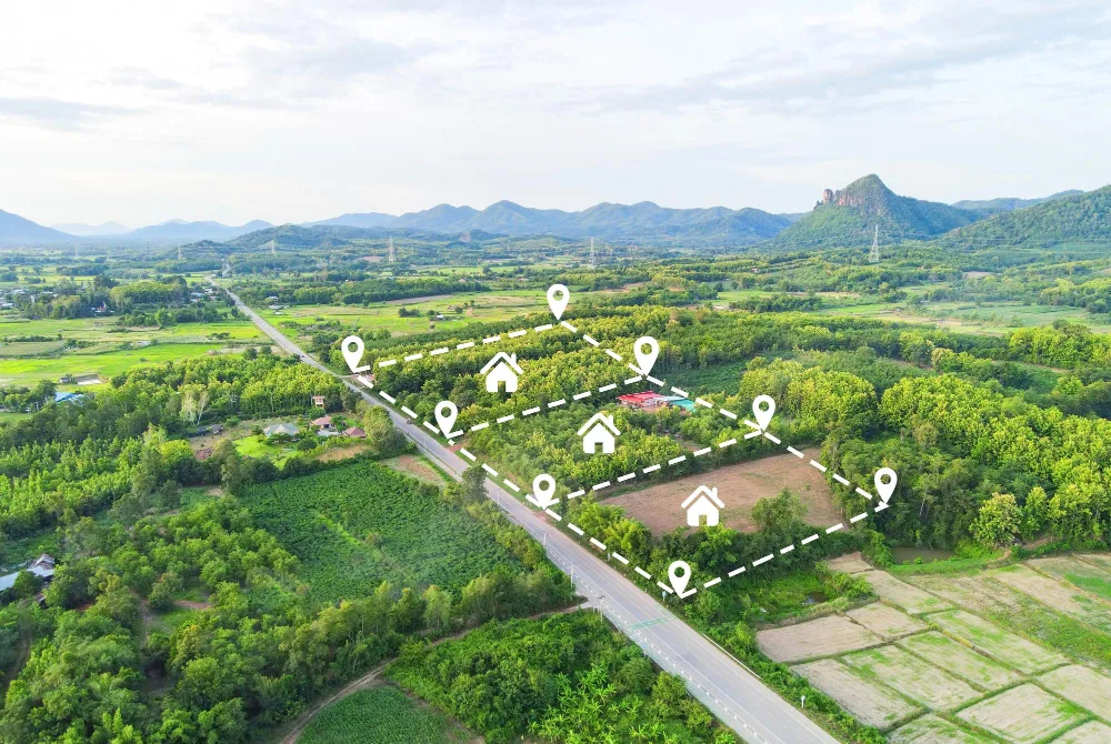
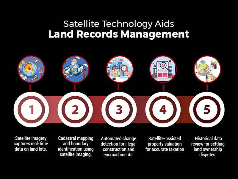
    Satellite imagery is the foundation of contemporary land management, as it allows for exact documentation, analysis, and tracking of land lots over massive regions. In contrast to error-prone, time-consuming ground surveys, satellite-based land mapping provides high-scale, real-time, and highly accurate knowledge.

    how satellite technology aids land records management

    The principal benefits of employing satellites in land records management are:

    • Extensive Coverage: Satellites can simultaneously cover entire states or the whole nation, enabling mass-scale mapping.
    • Availability of Historical Data: Satellite images taken decades ago enable monitoring of land-use patterns over decades, facilitating settlement of disputes relating to ownership.
    • Accessibility from Remote Locations: No requirement for physical field visits; the authorities can evaluate land even from remote areas.

    1. Cadastral Mapping – Determining Accurate Property Boundaries

    Cadastral maps are the legal basis for property ownership. Traditionally, they were manually drafted, with the result that they contained errors, boundary overlap, and owner disputes. Employing satellite imaging, GIS companies in India can now:

    • Map land parcels digitally, depicting boundaries accurately.
    • Cross-check land titles by layering historical data over satellite-derived cadastral data.
    • Identify encroachments by matching old records against new high-resolution imagery.

    For example, a landowner asserting additional land outside their legal boundary can be easily located using satellite-based cadastral mapping, assisting local authorities in correcting such instances.

    2. Land Use and Land Cover Classification (LULC)

    Land use classification is essential for urban, conservation, and infrastructure planning. GIS companies in India examine satellite images to classify land, including:

    • Agricultural land
    • Forests and protected areas
    • Residential, commercial, and industrial areas
    • Water bodies and wetlands
    • Barren land

    Such a classification aids the government in regulating zoning laws, tracking illegal land conversions, and enforcing environmental rules.

    For instance, the illegal conversion of agricultural land into residential areas can be easily identified using satellite imagery, allowing regulatory agencies to act against unlawful real estate development simultaneously.

    3. Automated Change Detection – Tracking Illegal Construction & Encroachments

    One of the biggest challenges in land administration is the proliferation of illegal constructions and unauthorized encroachments. Satellite-based GIS systems offer automated change detection, wherein:

    • Regular satellite scans detect new structures that do not match approved plans.
    • Illegal mining, deforestation, or land encroachments are flagged in real-time.
    • Land conversion violations (e.g., illegally converting wetlands into commercial zones) are automatically reported to authorities.

    For example, a satellite monitoring system identified the unauthorized expansion of a residential colony into government land in Rajasthan, which prompted timely action and legal proceedings.

    4. Satellite-Based Property Taxation & Valuation

    Correct property valuation is critical for equitable taxation and the generation of revenues. Property valuation traditionally depended on physical surveys, but satellites have made it a streamlined process:

    • Location-based appraisal: Distance to highways, commercial centers, and infrastructure developments is included in the tax calculation.
    • Footprint building analysis: Machine learning-based satellite imaging calculates covered areas, avoiding tax evasion.
    • Market trend comparison: Satellite photos and property sale data enable the government to levy property taxes equitably.

    For example, the municipal government in Bangalore utilized satellite images to spot almost 30,000 properties that had not been appropriately reported in tax returns, and the property tax revenue went up.

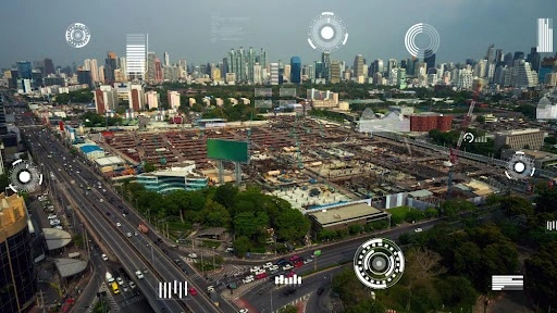
    How Drone Technology is Applied to Land Surveys & Property Management

    While satellites give macro-level information, drones collect high-accuracy, real-time, and localized data. Drones are indispensable in regions where extreme precision is required, such as:

    • Urban land surveys with millimeter-level accuracy.
    • Land disputes demanding legally admissible cadastral records.
    • Surveying terrain in hilly, forested, or inaccessible areas.
    • Rural land mapping under government schemes such as SVAMITVA.

    1. Drone-Based Cadastral Mapping & Land Surveys

    Drones with LiDAR sensors, high-resolution cameras, and GPS technology undertake automated cadastral surveys, allowing:

    • Accurate land boundary mapping, dispelling disputes.
    • Faster surveying (weeks rather than months), cutting down administrative delays.
    • Low-cost operations compared to conventional surveying.

    For example, drones are being employed to map rural land digitally under the SVAMITVA Scheme, issuing official property titles to millions of landholders.

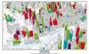
    2. 3D Modeling for Urban & Infrastructure Planning

    Drones produce precise 3D maps that offer:

    • Correct visualization of cityscapes for planning infrastructure projects.
    • Topography models that facilitate flood control and disaster management.
    • Better land valuation insights based on elevation, terrain, and proximity to amenities.

    For example, Mumbai’s urban planning department used drone-based 3D mapping to assess redevelopment projects, ensuring efficient use of land resources.

    3. AI-Powered Analysis of Drone Data

    Modern GIS software integrates Artificial Intelligence (AI) and Machine Learning (ML) to:

    • Detect unauthorized construction automatically.
    • Analyze terrain data for thoughtful city planning.
    • Classify land parcels for taxation and valuation purposes.

    For instance, a Hyderabad-based drone-based AI system identified illegal constructions and ensured compliance with urban planning regulations.

    Integration of GIS, Satellites & Drones into Land Information Systems

    Satellite and drone data are integrated into Intelligent Land Information Systems (ILIS) by GIS companies in India that encompass:

    A. System of Record (Digital Land Registry)

    • Geospatial database correlating land ownership, taxation, and legal titles.
    • Blockchain-based digital land records resistant to tampering.
    • Uninterrupted connectivity with legal and financial organizations.

    B. System of Insight (Automated Land Valuation & Analytics)

    • Artificial intelligence-based property valuation models based on geography, land topology, and urbanization.
    • Automated taxation ensures equitable revenue collection.

    C. System of Engagement (Public Access & Governance)

    • Internet-based GIS portals enable citizens to confirm property ownership electronically.
    • Live dashboards monitor land transactions, conflicts, and valuation patterns.

    Conclusion

    GIS, satellite imagery, and drones have transformed India’s land records and property management by making accurate mapping, real-time tracking, and valuation efficient. Satellites give high-level insights, while drones provide high-precision surveys, lowering conflicts and enhancing taxation.

    GIS companies in India like SCS Tech, with their high-end GIS strength, facilitate such data-based land administration, propelling India towards a transparent, efficient, and digitally integrated system of governance, guaranteeing equitable property rights, sustainable planning, and economic development.

  • The Importance of GIS Mapping Services in Oil & Gas Exploration and Management

    The Importance of GIS Mapping Services in Oil & Gas Exploration and Management

    In the high-stakes world of oil and gas, every decision matters—especially when it comes to exploration and infrastructure management. But how do industry leaders make the right call on where to dig, how to optimize their operations, and minimize risk? The answer lies in harnessing the power of Geographic Information Systems (GIS).

    As the GIS controller market heads towards an estimated 780 million USD by 2032, with an impressive annual growth rate of 13% from 2024 to 2032, the reliance on this cutting-edge technology is growing exponentially. Partnering with a trusted GIS company in Mumbai can provide the strategic edge needed to leverage this technology effectively. GIS isn’t just a tool; it’s a strategic advantage that turns raw data into actionable insights, helping companies boost safety, reduce costs, and make smarter, faster decisions in real time.

    GIS mapping services help them make smarter choices, increase safety, and save money by giving them highly detailed, real-time data about their operational environment. Read on for a look at how GIS boosts oil and gas exploration and management and how GIS companies in India are meeting the needs of the industry. To better understand how GIS achieves this, let’s explore its core functionalities in oil and gas exploration.

    GIS Data Integration and Visualization in Oil & Gas Exploration

    Data Integration

    GIS integrates different information types, which come from satellites and GPS data, as well as surveys on the geology of the subsurface and environmental reports. Because of this ability to integrate data types, companies can now get a better view of the big picture.

    In the operation of oil and gas exploration, among other information, GIS can consolidate knowledge of terrain, climatic conditions, and subsurface geology. With all this data on one map, companies can be better positioned to decide where to explore, where to drill, and get a better handle on their asset management.

    Data Layering

    Another essential feature of GIS is its ability to layer different types of data on a single map. For instance, oil and gas professionals can view geological, environmental, and infrastructural data together, helping them assess how landscapes, sensitive environments, and operational challenges might impact drilling decisions. This multi-layered approach simplifies complex analysis, improving planning and decision-making.

    Advanced GIS Tools in Oil & Gas Exploration

    LiDAR and Photogrammetry

    While GIS is the core platform for data visualization and analysis, it often works in tandem with tools like LiDAR (Light Detection and Ranging) and photogrammetry, which provide detailed 2D and 3D images of the terrain. These high-technology tools generate dense data sets that can be overlaid onto GIS systems for further analysis.

    For example, LiDAR is critical in oil and gas exploration because it helps assess the stability of the land, identifying safe drilling and pipeline routes while minimizing risks associated with unstable terrain. By integrating this data into GIS, companies can make more accurate decisions on where to drill or lay pipelines.

    Real-Time Data Processing

    GIS, when integrated with real-time monitoring systems such as SCADA (Supervisory Control and Data Acquisition) and IoT devices, allows companies to visualize real-time data. While GIS is not responsible for collecting this data, it plays a crucial role in analyzing and visualizing it.

    Real-time monitoring enables companies to track their assets, including pipelines and wells, and respond quickly to any potential issues, such as leaks or environmental hazards. GIS serves as the front-end interface, where teams can visualize real-time conditions and act swiftly to prevent costly damages or disasters.

    GIS Applications in Oil & Gas Exploration and Asset Management

    Exploration Optimization

    The exploration of oil and gas tends to be both expensive and risky. Companies can mitigate these risks using GIS mapping services, which provide information on the most optimal locations to drill based on data. GIS integrates seismic data, historical exploration records, and geological information to help determine sites that may have high-potential oil and gas reserves. This helps minimize drilling into unproductive areas. Therefore, losses in terms of time and money are minimal.

    Pipeline Management

    One of the most critical challenges in the oil and gas industry is managing pipelines, especially when they traverse rugged or environmentally sensitive terrain. GIS helps by analyzing land conditions, environmental risks, and potential obstacles, ensuring the safest and most cost-effective pipeline routes.

    Moreover, by integrating real-time data from monitoring systems, GIS can track the condition of pipelines and issue alerts when there is a risk of leakage or damage. This proactive management ensures that companies can address issues before they become significant problems, reducing the likelihood of environmental disasters and costly repairs.

    Environmental Impact Assessments

    Environmental considerations are of paramount importance in oil and gas operations. GIS is an invaluable tool for conducting Environmental Impact Assessments; it shows how operations may impact ecosystems in the near vicinity. Companies may overlay environmental data with operational maps to ensure that projects conform to ecological standards while minimizing adverse impacts on the surrounding area.

    Benefits of GIS in Oil & Gas Exploration and Management

    More Informed Decisions

    GIS lets oil and gas companies map out all their critical data in one place, making more intelligent and faster decisions during the asset life cycle’s exploration, development, and operations phases. Companies can then see detailed maps with information regarding geological risks and possible environmental impacts. This will thus decide whether a specific location is suitable to drill in turn saving money.

    Cost Savings

    Improving processes and increasing efficiency yields enormous savings for a company using GIS mapping services. Choosing a drilling location can save a lot of time and money since the loss of time and money through a non-productive site is avoided. More pipeline routing efficiency and current monitoring reduce more expensive repair work and avoid more downtime time. Operational expenses will be reduced.

    Cost Savings from GIS in Oil & Gas Operations

    Improved Safety

    Monitoring in real-time of hazards to safety and the environment of the oil and gas industry is essential. Even though GIS does not monitor equipment leaks or failure directly, it allows the companies to visualize and analyze data collected in real-time from other systems such as SCADA or IoT devices. In incidences, this system detects the problems, and by getting GIS images on display, the team can respond faster and stop further damage. This swift action does not only protect the workers but also helps avoid environmental disasters.

    The Future of GIS Mapping Services in Oil & Gas Industry

    The applications of GIS mapping services in oil and gas industries will have a promising future.

    • AI and Machine Learning Integration: Further AI and machine learning integration with GIS mapping services will likely spread its influence further. These technologies enable fast analysis of data and hidden patterns to help companies optimize drilling, predict equipment failures, and gain better operational efficiency.
    • Mobile GIS Applications: Mobile GIS applications are now becoming an essential aspect of field operations when mobile GIS can afford to reach far-flung areas. Realtime collection of data with instantaneous updating helps companies decide faster, communicate better, and reduce delays associated with oil and gas work activities.

    Key Takeaways

    GIS mapping services are changing the game in the oil and gas industry, where industries can make better decisions, reduce some of the costs, and become safer. GIS integrates various data, such as satellites and real-time sensor data, enabling compelling exploration, asset management, and regulatory compliance.

    GIS companies in India, such as SCS Tech India Pvt Ltd, are leading providers of GIS mapping services, which are increasingly vital to the oil and gas industry. We distinctively integrate advanced technologies with GIS applications, enhancing data accuracy and predictive capabilities for exploration, pipeline management, and environmental monitoring. Our solutions ensure precise, real-time mapping and analysis, optimizing efficiency and safety in high-risk and complex environments.

  • The Role of GIS Companies in Smart City Initiatives

    The Role of GIS Companies in Smart City Initiatives

    With over 55% of the world’s population now living in urban areas, the success and sustainability of these regions depend heavily on how well cities can manage their resources and address contingencies. GIS technology provides the backbone for these efforts, offering comprehensive solutions for urban planning, infrastructure management, environmental monitoring, and public safety. 

    Geographical Information Systems (GIS) technology is a cornerstone of modern urban development and management. GIS companies in India leverage this sophisticated technology to undertake a wide array of critical tasks—from designing and planning new urban spaces to the redevelopment of heritage cities. 

    In this blog, we discuss the multifaceted roles of GIS companies in India, emphasizing their contributions to smart city development and the extensive benefits they offer to urban environments. From economic growth and business support to transportation management and disaster response, GIS technology is revolutionizing how cities operate and thrive in an increasingly complex world.

    Significance of GIS Companies in the Smart City Framework

    Both small and large GIS companies in India offer essential tools and services for smart city development. Smaller firms might focus on specific tasks like traffic management, while larger organizations provide a comprehensive range of services from a central hub. 

    The Geographical information system software technology enables the use of locational data to make informed decisions, significantly contributing to smart city initiatives.

    Supporting Local Businesses

    GIS technology assists local businesses in maintaining visibility to potential customers, thereby boosting the economic prosperity of cities. When combined with public utility, topographic, environmental, and demographic data, GIS becomes a powerful tool for various industries. 

    Image Source:

    Applications like Google Maps exemplify how GIS can update information on demographics, public utilities, networks, roads, and local businesses, aiding decision-making processes.

    Environmental Sustainability and Monitoring

    Smart cities strive to be environmentally sustainable, and GIS companies play a crucial role in this by providing environmental monitoring services. The different methods to predict natural disasters used by GIS companies are as follows: 

    • Managing natural resources
    • Tracking changes in green areas
    • Mapping pollution levels

    Additionally, GIS aids in planning water conservation, waste management, and renewable energy projects, fostering healthier urban environments.

    Tracking the Water Sources

    A city’s underground and overground water sources are known as the lifeline of its people. Instead of utilizing the invasive process, the GIS companies in India use remote sensors to track down the water flow in the city. This helps identify whether or not a drought or impending flood occurs because of construction work.

    Response to Emergencies and Public Safety

    GIS-based tools enhance public safety and emergency response capabilities by integrating spatial data with incident management systems. GIS companies enable authorities to: 

    • Optimizing the emergency responses
    • Planning out the law enforcement-related activities
    • Mapping all the crime hotspots

    If there is a natural disaster, the GIS companies in India will use the incident command system in disaster management to coordinate rescue efforts, resource allocation, and damage assessment. This will lead to an efficient and instant response, aid recovery, and reduce loss.

    Economic Developments

    Through a detailed spatial analysis, companies can use GIS technology to find the best opportunities for economic development. Cities can pull in businesses by displaying their market potential, demographic trends, and real estate.

    GIS will also help in supporting tourism as it can point out all the amenities and attractions in a city, which will contribute towards economic growth.

    Transportation and Traffic

    For all the smart cities, managing traffic is highly essential. GIS companies can use the GIS system to analyze traffic patterns, manage public transportation systems, and optimize routes.

    These companies will also be able to integrate the GIS devices into the GIS platforms to deliver live updates on the traffic. This will enhance mobility and alleviate congestion.

    Urban Development and Planning

    Image Source:

    With the help of GIS technology, companies can help with the interpretation of spatial data, analysis, and visualization. All these things are compulsory for urban planning.

    Many planners utilize this particular technology to map the present infrastructure, model upcoming developments, and assess land usage.

    By doing so, planners can make correct decisions on environmental management, public-related services, and zoning the transportation networks.

    Understanding the Benefits of GIS Technology

    The GIS technology is equipped with countless advantages, and the table below will give you detailed information on them.

    GIS Technology Benefits The Description
    Disaster Management Emergency planning and risk assessment can improve response and preparedness during natural disasters.
    Market Analysis  Analysis of spatial data and demographics will help support the marketing approaches and business locations.
    Visualization Offering a visual representation with maps can improve communication and understanding. 
    Agriculture Provides support for crop management and accurate farming and helps monitor all agricultural activities.
    Education Helps in offering various tools for teaching environmental science, geography and many other fields.
    Crime Mapping Aids in analyzing all the crime patterns to improve public safety and law enforcement.
    Utility Management Helps in managing the infrastructure with numerous utilities like gas, electricity and water.
    Historical Preservation Enables the management and preservation of all the cultural heritages and historical locations. 

    Final Thoughts

    The GIS companies in India play a completely multifaceted part In the smart city industries. The GIS-based devices and tools that they have in store are compulsory for creating livable, sustainable, and efficient cities. This will make the GIS companies indispensable partners in the smart city environment. 

    Furthermore, at SCS Tech India PVT Ltd, we offer GIS-based solutions and services across the globe. Leveraging avant-garde technology, our offerings include enterprise solutions, cloud computing, eGoverance, blockchain solutions, IT infrastructure, digital transformation, and utility and energy solutions. 

    Our innovative services and solutions establish a robust digital foundation in today’s transformed world. Take advantage of our services across diverse sectors, including agriculture, education, finance, and healthcare. Get in touch with us to learn more!

  • Geospatial Intelligence for Efficient Supply Chains

    Geospatial Intelligence for Efficient Supply Chains

    The science of where things are is changing how we interact with the physical world. Geospatial science is changing how we think, and how we react. It allows us to look at the physical world as a comprehensive framework that integrates organizations and everyday life into it. Supply chains, being notoriously difficult to manage, especially in varied geography like India’s. The power of GIS lies in its ability to convert this accurate qualitative geospatial analysis into easy-to-use and easy to comprehend visual solutions. A virtual geospatial nexus.

    Hundreds of organizations around the world are using GIS to make maps to solve complex problems, this is changing how the world works. GIS helps to illuminate issues that are driven by geography. One of the best examples is that we have used GIS intelligence to analyze post-monsoon droughts for better agricultural output.

    Geospatial intelligence enabling Supply Chains


    One unique project is the digitization of an entire dairy supply chain via IoT we have been working on a project that uses GIS functionality tools throughout the entire supply chain from farm to fork.

    This project works in three stages, cattle monitoring, product procurement, and cold chain management. The cattle are monitored with a wearable pedometer, that relays location data, along with temperature and resting behavior. This helps monitor sleep patterns and disorders, keeping a check on the health and productivity of the animals.

    In the next stage of the supply chain, the milk is procured by an automatic collection unit, enabled with IoT. This enables the detection of impurities and increased transparency, allowing for real-time tracking of quantity and quality, then facilitating automatic payments. And all of this can be done remotely. The last stage calls for cold chain monitoring.

    Cold chain is notoriously hard to monitor and execute. SCS Tech is able to monitor the shelf life, collection, and transportation of milk via a web-based monitoring system. This system, when applied to milk coolers, silos or deep freezers allows real-time volume and temperature monitoring, alerts for equipment malfunction, and optimization of the power supply. This allows for remote monitoring and delivery of milk, assuring the quality and quantity throughout the supply chain.

    A Geospatial Nexus

    This geographic reality can be beamed onto organizations. And for many departments – emergency response, customer service, or government, the issues they are facing today can be resolved by bringing this information together in real-time. There is not too distant a future where we could visualize the relationship between cancers and pollution, to say, ‘we can quantify and relate these factors and as a result, respond’.

    A snapshot of the working of a Geospatial intelligence-enabled platform

    When SCS Tech was conceived, we built systems, first small, and focused on particular departments like engineering, marketing, or city planning. With focused projects, companies could make better decisions once they could identify all factors. From there we are moving on to transforming entire organizations, working our way towards building a geospatial nexus allowing organizations and society to be more conscious of the environment while making the most out of their operations.


  • How GIS Changed the Face of Modern Geography

    How GIS Changed the Face of Modern Geography

    There is no doubt about the fact that technology continues to transform the world in many immeasurable ways.

    But perhaps something that would grab everyone’s attention is how it has made the most complex things look easy. Take a case in point of schools and research centers, and further narrow down to a subject such as Geography. You will be awe-struck by some of the most cutting-edge development in modern times.

    Geographic information systems, also known as Geospatial information system (GIS) is a testament to how the integration of technology and academia is making it easy for students and researchers to study what would otherwise be impossible a few decades ago.

    A Brief History of GIS

    Many years ago, students of Geography depended on two-dimensional maps, something which made it difficult to explore the real world.  It meant things like Global Position Systems wouldn’t realize a lot of success, and people would be limited to studying areas of proximity.

    However, all this was to change when in the 1960s, a 28-year-old Canadian Geography student named Roger Tomlinson started developing what later became known as the first ever GIS software. The Canadian Land inventory embraced the approach.  At the same time, Howard Fisher, who was in Harvard at the same time was looking into prospects of bringing together data sets from map using statistic modeling software, shortly after which, the United States Census Bureau started applying his approach in demographic studies.

    What has changed in Geography?

    The following are notable facelifts that Geospatial information system has brought into modern Geographical studies:

    Widespread application in the study of planets (Astronomy Science)

    NASA can track the path of asteroids with greater ease than it was many years back. That’s not all. With Mars Orbiter Laser Altimeter (MOLA) onboard Mars Global Surveyor, scientists have been able to study the rugged terrain of a planet that has since shown traits of supporting human life. Talk about Mar Rover, Visible Earth, Google Earth, 3-Study of magnetic fields and many more; GIS is taking a toll on old approaches to Astronomy.

    Remote Sensing

    With the advent of GIS software, there was never going to be any doubt about how it would transform capabilities of remote sensing gadgets. Installation on the space station makes it easy to gather information about the outer space, include remotest parts on land.

    Demographics

    A lot has changed regarding demographic studies, or populations, thanks to the incorporation of GIS as an advanced computer technology for data collection. It is now easier to gather spatial statistics, simplify complex data and scale down the findings to dependable and precise findings. In this regard, researchers in this field of knowledge can realize the outcomes of their projects much faster and with more reliability using a data modeling approach.

    Improvement in tracking capabilities

    With GIS coming hot on the heels of the information age, tracking migrations of people, animals and weather changes has become easier than before.  Mapping, data analysis, and reporting are the mainstay activities in this approach.

    Meteorological studies

    Ever wondered how the weatherman knows about an impending hurricane, a potentially hazardous tornado or even a storm that is a few months away from flooding lowlands?  Well, it is all thanks to GIS impact on meteorology, a branch of geography that involves the study of climatic patterns.

    In summary, the Geospatial information system is changing the way people study the environment in which they live. And while its application is widespread in Geography, businesses also depend on it to satisfy the needs of clients.