Tag: SCS tech

  • How to Build a Digital Roadmap for Upstream Oil and Gas Operations

    How to Build a Digital Roadmap for Upstream Oil and Gas Operations

    Most upstream oil and gas teams already use some form of digital tools, whether it’s SCADA systems, production monitoring software, or sensor data from the field. These are all examples of oil and gas technology that play a critical role in modernizing upstream workflows.

    But in many cases, these tools don’t work well together. The result? Missed opportunities, duplicated effort, and slow decisions.

    A digital roadmap helps fix that. It gives you a clear plan to use technology in ways that actually improve drilling, production, and asset reliability, not by adding more tools, but by using the right ones in the right places.

    This article outlines the important elements for developing a viable, execution-ready plan specific to upstream operations.

    What a Digital Roadmap Looks Like in Upstream Oil and Gas

    In upstream oil and gas, a digital roadmap isn’t a general IT plan; it’s an execution-driven guide tailored for field operations across drilling, production, and asset reliability. These roadmaps prioritize production efficiency, not buzzword technology.

    A practical digital transformation in oil and gas depends on grounding innovation in field-level reality, not just boardroom strategy.

    Most upstream firms are using technologies like SCADA or reservoir software, but these often remain siloed.  A smart roadmap connects the dots, taking fragmented tools and turning them into a system that generates measurable value in the field.

    Here’s what to include:

    • Use Case Alignment – Focus on high-impact upstream areas: drilling automation, asset integrity, reservoir management, and predictive maintenance. McKinsey estimates digital tech can reduce upstream operating costs by 3–5 % and capex by up to 20 %.
    • Targeted Technology Mapping – Defining where AI/IOT or advanced analytics fit into daily operations is invaluable.  This is where next-gen oil and gas technology, such as edge computing and real-time analytics, can proactively prevent failure and improve uptime.
    • Data Infrastructure Planning – Address how real-time well data, sensor streams, and historical logs are collected and unified. McKinsey highlights that 70 % of oil firms stall in pilot phases due to fragmented data systems and a lack of integrated OT/IT infrastructure.
    • Phased Rollout Strategy – Begin with focused pilots, like real-time drilling performance tracking, then expand to multiple fields. Shell and Chevron have successfully used this playbook: validating gains at a small scale before scaling asset-wide


    Rather than a one-size-fits-all framework, a strong upstream digital roadmap is asset-specific, measurable, and built for execution, not just strategy decks. It helps upstream companies avoid digitizing for the sake of it, and instead focus on what actually moves the needle in the field.

    Building a Digital Roadmap for Upstream Oil and Gas Operations

    A digital roadmap helps upstream oil and gas teams plan how and where to use technology across their operations. It’s not just about picking new tools, it’s about making sure those tools actually improve drilling, production, and day-to-day fieldwork. 

    The following are the critical steps to creating a roadmap that supports real goals, not just upgrades to digital.

    Step 1: Define Business Priorities and Operational Pain Points

    Before looking at any technology, you need to clearly understand what problem you’re trying to solve – that’s step one to building a digital roadmap that works, not just for corporate, but also for the people who are running wells, rigs, and operations every day.

    This starts by answering one question: What are the business outcomes your upstream team needs to improve in the next 12–24 months?

    It could be:

    • Reducing non-productive time (NPT) in drilling operations
    • Improving the uptime of compressors, pumps, or separators
    • Lowering the cost per barrel in mature fields
    • Meeting environmental compliance more efficiently
    • Speeding up production reporting across locations

    These are not just IT problems; they’re business priorities that must shape your digital plan.

    For each priority, define the metric that tells you whether you’re moving in the right direction.

    Business priority  Metric to track 
    Reduce NPT in drilling  Avg. non-productive hours per rig/month 
    Improve asset reliability  Unplanned downtime hours pre-asset 
    Lower operational costs  Costs per barrel (OPEX) 
    Meet ESG reporting requirements  Time to compile and validate compliance data 


    It is simple to understand which digital use cases merit efforts once you have assigned numbers to the goals you established. This is where strategic oil and gas industry consulting adds value by turning operational pain points into measurable digital opportunities.

    Step 2: Audit Your Existing Digital Capabilities and Gaps

    Now that you have the agreed consideration for what priorities you want to strengthen in your upstream activities, the second step is to identify your existing data capabilities, tools, and systems, and assess how well they support what you want to achieve.

    It is not an inventory of software. You’re reviewing:

    • What you have
    • What you’re underutilizing
    • What’s old or difficult to scale
    • And what you’re completely lacking

    Pillars of Digital Readiness Audit

    A successful digital transformation in oil and gas starts with a clear-eyed view of your current tools, gaps, and data flows.

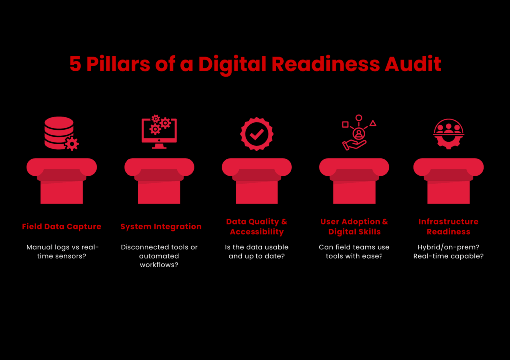
    Focus Areas for a Practical Digital Audit

    Your audit should consider five priority areas:

    1. Field Data Capture
      • Do you still use manual logs or spreadsheets for day-to-day production, asset status, or safety reports?
      • Do you have sensors or edge devices? Are they available and connected?
      • Is field data captured in real-time or batched uploads?
    2. System Integration
      • Are SCADA, ERP, maintenance software, and reporting tools communicating?
      • Are workflows between systems automated or manually exported/imported?
    3. Data Quality and Accessibility
      • How up-to-date, complete, and clean is your operational data?
      • Do engineers and analysts access insights easily, or do they depend on IT every time?
    4. User Adoption and Digital Skill Levels
      • Are digital tools easy to use by field teams?
      • Is there ongoing training for digital tools besides initial rollouts?
    5. Infrastructure Readiness
      • Are you running on cloud, on-premises, or a hybrid setup?
      • Do remote sites have enough connectivity to support real-time monitoring or analytics?

    Step 3: Prioritize High-Impact Use Cases for Digitization

    A digital roadmap fails when it attempts to do too much or gets the wrong priorities. That’s why this step is about selecting the correct digital use cases to begin with.

    You don’t require a long list. You require the correct 3–5 use cases that align with your field requirements, provide early traction, and enable you to gain momentum.

    How to Select and Prioritize the Right Use Cases

    Use three filters:

    • Business Impact

    Does it materially contribute to your objectives from Step 1? Can it decrease downtime, save money, enhance safety, or accelerate reporting?

    • Feasibility

    Do you have sufficient data and infrastructure to enable it? Can you deploy it with your existing team or partners?

    • Scalability

    If it works in one site, can you expand it across other wells, rigs, or regions?

    Plot your candidates on a simple Impact vs. Effort matrix and focus first on the high-impact, low-effort quadrant.

    These examples have been validated industry-wide in both onshore and offshore environments:

    Use cases  What it solves  Why it works 
    Predictive maintenance for rotating equipment  Unexpected failures, costly unplanned downtime Can reduce maintenance costs by up to 25% and unplanned outages by 70% (GE Digital)
    Automated drilling performance tracking  Slow manual analysis of rig KPIs  Speeds up decision-making during drilling and improves safety 
    Remote monitoring of good conditions  Infrequent site visits, delayed issue detection  Supports real-time response and better resource allocation 
    AI-driven production forecasting  Inaccurate short-term forecasts, missed targets  Helps optimize lift strategies and resource planning 
    Digital permit to work systems  Paper-based HSE workflows  Improves compliance tracking and field audit readiness 


    Don’t select use cases solely on tech appeal. Even AI won’t work if there’s dirty data or your field staff can’t use it confidently.

    Step 4: Build a Phased Roadmap with Realistic Timelines

    Many digital transformation efforts in upstream oil and gas lose momentum because they try to do too much, too fast. Teams get overwhelmed, budgets stretch thin, and progress stalls. The solution? Break your roadmap into manageable phases, tied to clear business outcomes and operational maturity.

    Many upstream leaders leverage oil and gas industry consulting to design phased rollouts that reduce complexity and accelerate implementation.

    Here’s how to do it in practice.

    Consider your shortlist in Step 3. Don’t try to do it all immediately. Rather, classify each use case into one of three buckets:

    • Quick wins (low complexity and ready for piloting)
    • Mid-range initiatives (need integrations or cross-site collaboration)
    • Long-term bets (advanced analytics, AI, or full-scale automation)

    Suppose you begin with production reporting and asset monitoring:

    Phase  What happens  When 
    Test  Pilot asset condition monitoring on 3 pumps Month 1-3
    Expand  Roll out monitoring to 20+ pumps across fields Month 4-12 
    Integrate  Link monitoring with maintenance dispatch + alert automation  Month 13-24


    This strategy prevents your teams from getting tech-fatigued. Every victory wins over trust. And above all, it makes leadership visible, measurable value, nota  digital aspiration.

    Step 5: Monitor, Iterate, and Scale Across Assets

    Once your roadmap is in motion, don’t stop at rollout. You need to keep track of what’s working, fix what isn’t, and expand only what brings real results. This step is about building consistency, not complexity.

    • Regularly review KPIs to determine if targets are being achieved
    • Gather field feedback to identify adoption problems or technical holes
    • Enhance and evolve based on actual usage, not projections
    • Scale established solutions to comparable assets with aligned needs and infrastructure

    This keeps your roadmap current and expanding, rather than wasting time on tools that do not yield results.

    Conclusion

    Creating a digital roadmap for upstream oil and gas operations isn’t a matter of pursuing fads or purchasing more software. Effective use of oil and gas technology is less about adopting every new tool and more about applying the right tech in the right phase of field operations.

    It’s setting your sights on the right objectives, leveraging what you already have better, and deploying technology in a manner that your teams can realistically use and expand upon.

    This guide took you through every step:

    • How to set actual operational priorities
    • How to conduct an audit of your existing capability
    • How to select and deploy high-impact use cases
    • How to get it all done on the ground, over time

    But even the most excellent roadmap requires experience behind it, particularly when field realities, integration nuances, and production pressures are at play.

    That’s where SCSTech is.

    We’ve helped upstream teams design and implement digital strategies that don’t just look good on paper but deliver measurable value across assets, people, and workflows. From early audits to scaled deployments, our oil and gas industry consulting team knows how to align tech decisions with business outcomes.

    If you’re planning to move forward with a digital roadmap, talk to us at SCSTech. We can help you turn the right ideas into real, field-ready results.

  • Can RPA Work With Legacy Systems? Here’s What You Need to Know!

    Can RPA Work With Legacy Systems? Here’s What You Need to Know!

    It’s a question more IT leaders are asking as automation pressures rise and modernization budgets lag behind. 

    While robotic process automation (RPA) promises speed, scale, and relief from manual drudgery, most organizations aren’t operating in cloud-native environments. They’re still tied to legacy systems built decades ago and not exactly known for playing well with new tech.

    So, can RPA actually work with these older systems? Short answer: yes, but not without caveats. This article breaks down how RPA fits into legacy infrastructure, what gets in the way, and how smart implementation can turn technical debt into a scalable automation layer.

    Let’s get into it.

    Understanding the Compatibility Between RPA and Legacy Systems

    Legacy systems aren’t built for modern integration, but that’s exactly where RPA finds its edge. Unlike traditional automation tools that depend on APIs or backend access, RPA Services works through the user interface, mimicking human interactions with software. That means even if a system is decades old, closed off, or no longer vendor-supported, RPA can still operate on it, safely and effectively.

    This compatibility isn’t a workaround — it’s a deliberate strength. For companies running mainframes, terminal applications, or custom-built software, RPA offers a non-invasive way to automate without rewriting the entire infrastructure.

    How RPA Maintains Compatibility with Legacy Systems:

    • UI-Level Interaction: RPA tools replicate keyboard strokes, mouse clicks, and field entries, just like a human operator, regardless of how old or rigid the system is.
    • No Code-Level Dependencies: Since bots don’t rely on source code or APIs, they work even when backend integration isn’t possible.
    • Terminal Emulator Support: Most RPA platforms include support for green-screen mainframes (e.g., TN3270, VT100), enabling interaction with host-based systems.
    • OCR & Screen Scraping: For systems that don’t expose readable text, bots can use optical character recognition (OCR) to extract and process data.
    • Low-Risk Deployment: Because RPA doesn’t alter the underlying system, it poses minimal risk to legacy environments and doesn’t interfere with compliance.

    Common Challenges When Connecting RPA to Legacy Environments

    While RPA is compatible with most legacy systems on the surface, getting it to perform consistently at scale isn’t always straightforward. Legacy environments come with quirks — from unpredictable interfaces to tight access restrictions — that can compromise bot reliability and performance if not accounted for early.

    Some of the most common challenges include:

    1. Unstable or Inconsistent Interfaces

    Legacy systems often lack UI standards. A small visual change — like a shifted field or updated window — can break bot workflows. Since RPA depends on pixel- or coordinate-level recognition in these cases, any visual inconsistency can cause the automation to fail silently.

    2. Limited Access or Documentation

    Many legacy platforms have little-to-no technical documentation. Access might be locked behind outdated security protocols or hardcoded user roles. This makes initial configuration and bot design harder, especially when developers need to reverse-engineer interface logic without support from the original vendor.

    3. Latency and Response Time Issues

    Older systems may not respond at consistent speeds. RPA bots, which operate on defined wait times or expected response behavior, can get tripped up by delays, resulting in skipped steps, premature entries, or incorrect reads.

    Advanced RPA platforms allow dynamic wait conditions (e.g., “wait until this field appears”) rather than fixed timers.

    4. Citrix or Remote Desktop Environments

    Some legacy apps are hosted on Citrix or RDP setups where bots don’t “see” elements the same way they would on local machines. This forces developers to rely on image recognition or OCR, which are more fragile and require constant calibration.

    5. Security and Compliance Constraints

    Many legacy systems are tied into regulated environments — banking, utilities, government — where change control is strict. Even though RPA is non-invasive, introducing bots may still require IT governance reviews, user credential rules, and audit trails to pass compliance.

    Best Practices for Implementing RPA with Legacy Systems

    Best Practices for Successful RPA in Legacy Systems

    Implementing RPA Development Services in a legacy environment is not plug-and-play. While modern RPA platforms are built to adapt, success still depends on how well you prepare the environment, design the workflows, and choose the right processes.

    Here are the most critical best practices:

    1. Start with High-Volume, Rule-Based Tasks

    Legacy systems often run mission-critical functions. Instead of starting with core processes, begin with non-invasive, rule-driven workflows like:

    • Data extraction from mainframe screens
    • Invoice entry or reconciliation
    • Batch report generation

    These use cases deliver ROI fast and avoid touching business logic, minimizing risk. 

    2. Use Object-Based Automation Where Possible

    When dealing with older apps, UI selectors (object-based interactions) are more stable than image recognition. But not all legacy systems expose selectors. Identify which parts of the system support object detection and prioritize automations there.

    Tools like UiPath and Blue Prism offer hybrid modes (object + image) — use them strategically to improve reliability.

    3. Build In Exception Handling and Logging from Day One

    Legacy systems can behave unpredictably — failed logins, unexpected pop-ups, or slow responses are common. RPA bots should be designed with:

    • Try/catch blocks for known failures
    • Timeouts and retries for latency
    • Detailed logging for root-cause analysis

    Without this, bot failures may go undetected, leading to invisible operational errors — a major risk in high-compliance environments.

    4. Mirror the Human Workflow First — Then Optimize

    Start by replicating how a human would perform the task in the legacy system. This ensures functional parity and easier stakeholder validation. Once stable, optimize:

    • Reduce screen-switches
    • Automate parallel steps
    • Add validations that the system lacks

    This phased approach avoids early overengineering and builds trust in automation.

    5. Test in Production-Like Environments

    Testing legacy automation in a sandbox that doesn’t behave like production is a common failure point. Use a cloned environment with real data or test after hours in production with read-only roles, if available.

    Legacy UIs often behave differently depending on screen resolution, load, or session type — catch this early before scaling.

    6. Secure Credentials with Vaults or IAM

    Hardcoding credentials for bots in legacy systems is a major compliance red flag. Use:

    • RPA-native credential vaults (e.g., CyberArk integrations)
    • Role-based access controls
    • Scheduled re-authentication policies

    This reduces security risk while keeping audit logs clean for governance teams.

    7. Loop in IT, Not Just Business Teams

    Legacy systems are often undocumented or supported by a single internal team. Avoid shadow automation. Work with IT early to:

    • Map workflows accurately
    • Get access permissions
    • Understand system limitations

    Collaboration here prevents automation from becoming brittle or blocked post-deployment.

    RPA in legacy environments is less about brute-force automation and more about thoughtful design under constraint. Build with the assumption that things will break — and then build workflows that recover fast, log clearly, and scale without manual patchwork.

    Is RPA a Long-Term Solution for Legacy Systems?

    Yes, but only when used strategically. 

    RPA isn’t a forever fix for legacy systems, but it is a durable bridge, one that buys time, improves efficiency, and reduces operational friction while companies modernize at their own pace.

    For utility, finance, and logistics firms still dependent on legacy environments, RPA offers years of viable value when:

    • Deployed with resilience and security in mind
    • Designed around the system’s constraints, not against them
    • Scaled through a clear governance model

    However, RPA won’t modernize the core, it enhances what already exists. For long-term ROI, companies must pair automation with a roadmap that includes modernization or system transformation in parallel.

    This is where SCSTech steps in. We don’t treat robotic process automation as a tool; we approach it as a tactical asset inside larger modernization strategy. Whether you’re working with green-screen terminals, aging ERP modules, or disconnected data silos, our team helps you implement automation that’s reliable now, but aligned with where your infrastructure needs to go.

  • How AgTech Startups Use GIS to Optimize Irrigation and Crop Planning

    How AgTech Startups Use GIS to Optimize Irrigation and Crop Planning

    Farming isn’t uniform. In the evolving landscape of agriculture & technology, soil properties, moisture levels, and crop needs can change dramatically within meters — yet many irrigation strategies still treat fields as a single, homogenous unit.

    GIS (Geographic Information Systems) offers precise, location-based insights by layering data on soil texture, elevation, moisture, and crop growth stages. This spatial intelligence lets AgTech startups move beyond blanket irrigation to targeted water management.

    By integrating GIS with sensor data and weather models, startups can tailor irrigation schedules and volumes to the specific needs of micro-zones within a field. This approach reduces inefficiencies, helps conserve water, and supports consistent crop performance.

    Importance of GIS in Agriculture for Irrigation and Crop Planning

    Agriculture isn’t just about managing land. It’s about managing variation. Soil properties shift within a few meters. Rainfall patterns change across seasons. Crop requirements differ from one field to the next. Making decisions based on averages or intuition leads to wasted water, underperforming yields, and avoidable losses.

    GIS (Geographic Information Systems) is how AgTech startups leverage agriculture & technology innovations to turn this variability into a strategic advantage.

    GIS gives a spatial lens to data that was once trapped in spreadsheets or siloed systems. With it, agri-tech innovators can:

    • Map field-level differences in soil moisture, slope, texture, and organic content — not as general trends but as precise, geo-tagged layers.
    • Align irrigation strategies with crop needs, landform behavior, and localized weather forecasts.
    • Support real-time decision-making, where planting windows, water inputs, and fertilizer applications are all tailored to micro-zone conditions.

    To put it simply: GIS enables location-aware farming. And in irrigation or crop planning, location is everything.

    A one-size-fits-all approach may lead to 20–40% water overuse in certain regions and simultaneous under-irrigation in others. By contrast, GIS-backed systems can reduce water waste by up to 30% while improving crop yield consistency, especially in water-scarce zones.

    GIS Data Layers Used for Irrigation and Crop Decision-Making

    GIS Data Layers Powering Smarter Irrigation and Crop Planning

    The power of GIS lies in its ability to stack different data layers — each representing a unique aspect of the land — into a single, interpretable visual model. For AgTech startups focused on irrigation and crop planning, these layers are the building blocks of smarter, site-specific decisions.

    Let’s break down the most critical GIS layers used in precision agriculture:

    1. Soil Type and Texture Maps

    • Determines water retention, percolation rate, and root-zone depth
    • Clay-rich soils retain water longer, while sandy soils drain quickly
    • GIS helps segment fields into soil zones so that irrigation scheduling aligns with water-holding capacity

    Irrigation plans that ignore soil texture can lead to overwatering on heavy soils and water stress on sandy patches — both of which hurt yield and resource efficiency.

    2. Slope and Elevation Models (DEM – Digital Elevation Models)

    • Identifies water flow direction, runoff risk, and erosion-prone zones
    • Helps calculate irrigation pressure zones and place contour-based systems effectively
    • Allows startups to design variable-rate irrigation plans, minimizing water pooling or wastage in low-lying areas

    3. Soil Moisture and Temperature Data (Often IoT Sensor-Integrated)

    • Real-time or periodic mapping of subsurface moisture levels powered by artificial intelligence in agriculture
    • GIS integrates this with surface temperature maps to detect drought stress or optimal planting windows

    Combining moisture maps with evapotranspiration models allows startups to trigger irrigation only when thresholds are crossed, avoiding fixed schedules.

    4. Crop Type and Growth Stage Maps

    • Uses satellite imagery or drone-captured NDVI (Normalized Difference Vegetation Index)
    • Tracks vegetation health, chlorophyll levels, and biomass variability across zones
    • Helps match irrigation volume to crop growth phase — seedlings vs. fruiting stages have vastly different needs

    Ensures water is applied where it’s needed most, reducing waste and improving uniformity.

    5. Historical Yield and Input Application Maps

    • Maps previous harvest outcomes, fertilizer applications, and pest outbreaks
    • Allows startups to overlay these with current-year conditions to forecast input ROI

    GIS can recommend crop shifts or irrigation changes based on proven success/failure patterns across zones.

    By combining these data layers, GIS creates a 360° field intelligence system — one that doesn’t just react to soil or weather, but anticipates needs based on real-world variability.

    How GIS Helps Optimize Irrigation in Farmlands

    Optimizing irrigation isn’t about simply adding more sensors or automating pumps. It’s about understanding where, when, and how much water each zone of a farm truly needs — and GIS is the system that makes that intelligence operational.

    Here’s how AgTech startups are using GIS to drive precision irrigation in real, measurable steps:

    1. Zoning Farmlands Based on Hydrological Behavior

    Using GIS, farmlands are divided into irrigation management zones by analyzing soil texture, slope, and historical moisture retention.

    • High clay zones may need less frequent, deeper irrigation
    • Sandy zones may require shorter, more frequent cycles
    • GIS maps these zones down to a 10m x 10m (or even finer) resolution, enabling differentiated irrigation logic per zone

    Irrigation plans stop being uniform. Instead, water delivery matches the absorption and retention profile of each micro-zone.

    2. Integrating Real-Time Weather and Evapotranspiration Data

    GIS platforms integrate satellite weather feeds and localized evapotranspiration (ET) models — which calculate how much water a crop is losing daily due to heat and wind.

    • The system then compares ET rates with real-time soil moisture data
    • When depletion crosses a set threshold (say, 50% of field capacity), GIS triggers or recommends irrigation — tailored by zone

    3. Automating Variable Rate Irrigation (VRI) Execution

    AgTech startups link GIS outputs directly with VRI-enabled irrigation systems (e.g., pivot systems or drip controllers).

    • Each zone receives a customized flow rate and timing
    • GIS controls or informs nozzles and emitters to adjust water volume on the move
    • Even during a single irrigation pass, systems adjust based on mapped need levels

    4. Detecting and Correcting Irrigation Inefficiencies

    GIS helps track where irrigation is underperforming due to:

    • Blocked emitters or leaks
    • Pressure inconsistencies
    • Poor infiltration zones

    By overlaying actual soil moisture maps with intended irrigation plans, GIS identifies deviations — sometimes in near real-time.

    Alerts are sent to field teams or automated systems to adjust flow rates, fix hardware, or reconfigure irrigation maps.

    5. Enabling Predictive Irrigation Based on Crop Stage and Forecasts

    GIS tools layer crop phenology models (growth stage timelines) with weather forecasts.

    • For example, during flowering stages, water demand may spike 30–50% for many crops.
    • GIS platforms model upcoming rainfall and temperature shifts, helping plan just-in-time irrigation events before stress sets in.

    Instead of reactive watering, farmers move into data-backed anticipation — a fundamental shift in irrigation management.

    GIS transforms irrigation from a fixed routine into a dynamic, responsive system — one that reacts to both the land’s condition and what’s coming next. AgTech startups that embed GIS into their irrigation stack aren’t just conserving water; they’re building systems that scale intelligently with environmental complexity.

    Conclusion

    GIS is no longer optional in modern agriculture & technology — it’s how AgTech startups bring precision to irrigation and crop planning. From mapping soil zones to triggering irrigation based on real-time weather and crop needs, GIS turns field variability into a strategic advantage.

    But precision only works if your data flows into action. That’s where SCSTech comes in. Our GIS solutions help AgTech teams move from scattered data to clear, usable insights, powering smarter irrigation models and crop plans that adapt to real-world conditions.

  • Using GIS Mapping to Identify High-Risk Zones for Earthquake Preparedness

    Using GIS Mapping to Identify High-Risk Zones for Earthquake Preparedness

    GIS mapping combines seismicity, ground conditions, building exposure, and evacuation routes into multi-layer, spatial models. This gives a clear, specific image of where the greatest dangers are — a critical function in disaster response software designed for earthquake preparedness.

    Using this information, planners and emergency responders can target resources, enhance infrastructure strength, and create effective evacuation plans individualized for the zones that require it most.

    In this article, we dissect how GIS maps pinpoint high-risk earthquake areas and why this spatial accuracy is critical to constructing wiser, life-saving readiness plans.

    Why GIS Mapping Matters for Earthquake Preparedness?

    When it comes to earthquake resilience, geography isn’t just a consideration — it’s the whole basis of risk. The key to minimal disruption versus disaster is where the infrastructure is located, how the land responds when stressed, and what populations are in the path.

    That’s where GIS mapping steps in — not as a passive data tool, but as a central decision engine for risk identification and GIS and disaster management planning.

    Here’s why GIS is indispensable:

    • Earthquake risk is spatially uneven. Some zones rest directly above active fault lines, others lie on liquefiable soil, and many are in structurally vulnerable urban cores. GIS doesn’t generalize — it pinpoints. It visualizes how these spatial variables overlap and create compounded risks.
    • Preparedness needs layered visibility. Risk isn’t just about tectonics. It’s about how seismic energy interacts with local geology, critical infrastructure, and human activity. GIS allows planners to stack these variables — seismic zones, building footprints, population density, utility lines — to get a granular, real-time understanding of risk concentration.
    • Speed of action depends on the clarity of data. During a crisis, knowing which areas will be hit hardest, which routes are most likely to collapse, and which neighborhoods lack structural resilience is non-negotiable. GIS systems provide this insight before the event, enabling governments and agencies to act, not react.

    GIS isn’t just about making maps look smarter. It’s about building location-aware strategies that can protect lives, infrastructure, and recovery timelines.

    Without GIS, preparedness is built on assumptions. With it, it’s built on precision.

    How GIS Identifies High-Risk Earthquake Zones

    How GIS Maps Earthquake Risk Zones with Layered Precision

    Not all areas within an earthquake-prone region carry the same level of risk. Some neighborhoods are built on solid bedrock. Others sit on unstable alluvium or reclaimed land that could amplify ground shaking or liquefy under stress. What differentiates a moderate event from a mass-casualty disaster often lies in these invisible geographic details.

    Here’s how it works in operational terms:

    1. Layering Historical Seismic and Fault Line Data

    GIS platforms integrate high-resolution datasets from geological agencies (like USGS or national seismic networks) to visualize:

    • The proximity of assets to fault lines
    • Historical earthquake occurrences — including magnitude, frequency, and depth
    • Seismic zoning maps based on recorded ground motion patterns

    This helps planners understand not just where quakes happen, but where energy release is concentrated and where recurrence is likely.

    2. Analyzing Geology and Soil Vulnerability

    Soil type plays a defining role in earthquake impact. GIS systems pull in geoengineering layers that include:

    • Soil liquefaction susceptibility
    • Slope instability and landslide zones
    • Water table depth and moisture retention capacity

    By combining this with surface elevation models, GIS reveals which areas are prone to ground failure, wave amplification, or surface rupture — even if those zones are outside the epicenter region.

    3. Overlaying Built Environment and Population Exposure

    High-risk zones aren’t just geological — they’re human. GIS integrates urban planning data such as:

    • Building density and structural typology (e.g., unreinforced masonry, high-rise concrete)
    • Age of construction and seismic retrofitting status
    • Population density during day/night cycles
    • Proximity to lifelines like hospitals, power substations, and water pipelines

    These layers turn raw hazard maps into impact forecasts, pinpointing which blocks, neighborhoods, or industrial zones are most vulnerable — and why.

    4. Modeling Accessibility and Emergency Constraints

    Preparedness isn’t just about who’s at risk — it’s also about how fast they can be reached. GIS models simulate:

    • Evacuation route viability based on terrain and road networks
    • Distance from emergency response centers
    • Infrastructure interdependencies — e.g., if one bridge collapses, what neighborhoods become unreachable?

    GIS doesn’t just highlight where an earthquake might hit — it shows where it will hurt the most, why it will happen there, and what stands to be lost. That’s the difference between reacting with limited insight and planning with high precision.

    Key GIS Data Inputs That Influence Risk Mapping

    Accurate identification of earthquake risk zones depends on the quality, variety, and granularity of the data fed into a GIS platform. Different datasets capture unique risk factors, and when combined, they paint a comprehensive picture of hazard and vulnerability.

    Let’s break down the essential GIS inputs that drive earthquake risk mapping:

    1. Seismic Hazard Data

    This includes:

    • Fault line maps with exact coordinates and fault rupture lengths
    • Historical earthquake catalogs detailing magnitude (M), depth (km), and frequency
    • Peak Ground Acceleration (PGA) values: A critical metric used to estimate expected shaking intensity, usually expressed as a fraction of gravitational acceleration (g). For example, a PGA of 0.4g indicates ground shaking with 40% of Earth’s gravity force — enough to cause severe structural damage.

    GIS integrates these datasets to create probabilistic seismic hazard maps. These maps often express risk in terms of expected ground shaking exceedance within a given return period (e.g., 10% probability of exceedance in 50 years).

    2. Soil and Geotechnical Data

    Soil composition and properties modulate seismic wave behavior:

    • Soil type classification (e.g., rock, stiff soil, soft soil) impacts the amplification of seismic waves. Soft soils can increase shaking intensity by up to 2-3 times compared to bedrock.
    • Liquefaction susceptibility indexes quantify the likelihood that saturated soils will temporarily lose strength, turning solid ground into a fluid-like state. This risk is highest in loose sandy soils with shallow water tables.
    • Slope and landslide risk models identify areas where shaking may trigger secondary hazards such as landslides, compounding damage.

    GIS uses Digital Elevation Models (DEM) and borehole data to spatially represent these factors. Combining these with seismic data highlights zones where ground failure risks can triple expected damage.

    3. Built Environment and Infrastructure Datasets

    Structural vulnerability is central to risk:

    • Building footprint databases detail the location, size, and construction material of each structure. For example, unreinforced masonry buildings have failure rates up to 70% at moderate shaking intensities (PGA 0.3-0.5g).
    • Critical infrastructure mapping covers hospitals, fire stations, water treatment plants, power substations, and transportation hubs. Disruption in these can multiply casualties and prolong recovery.
    • Population density layers often leverage census data and real-time mobile location data to model daytime and nighttime occupancy variations. Urban centers may see population densities exceeding 10,000 people per square kilometer, vastly increasing exposure.

    These datasets feed into risk exposure models, allowing GIS to calculate probable damage, casualties, and infrastructure downtime.

    4. Emergency Access and Evacuation Routes

    GIS models simulate accessibility and evacuation scenarios by analyzing:

    • Road network connectivity and capacity
    • Bridges and tunnels’ structural health and vulnerability
    • Alternative routing options in case of blocked pathways

    By integrating these diverse datasets, GIS creates a multi-dimensional risk profile that doesn’t just map hazard zones, but quantifies expected impact with numerical precision. This drives data-backed preparedness rather than guesswork.

    Conclusion 

    By integrating seismic hazard patterns, soil conditions, urban vulnerability, and emergency logistics, GIS equips utility firms, government agencies, and planners with the tools to anticipate failures before they happen and act decisively to protect communities, exactly the purpose of advanced methods to predict natural disasters and robust disaster response software.

    For organizations committed to leveraging cutting-edge technology to enhance disaster resilience, SCSTech offers tailored GIS solutions that integrate complex data layers into clear, operational risk maps. Our expertise ensures your earthquake preparedness plans are powered by precision, making smart, data-driven decisions the foundation of your risk management strategy.

  • What Role Does Blockchain Play in Streamlining Identity Verification for eGovernance Solutions?

    What Role Does Blockchain Play in Streamlining Identity Verification for eGovernance Solutions?

    What if identity verification didn’t mean endless waits, repeated paperwork, and constant data theft risks? These problems are the setbacks of outdated systems, slowing down public services and putting sensitive information at risk. Blockchain solves these issues by streamlining identity verification in eGovernance solutions. It reduces paperwork, speeds up validation, and ensures transparency and security in the process used by governments to verify citizens.

    Blockchain provides a real-time auditable record because of its unique, decentralized, and tamperproof architecture. By this, blockchains ensure clarity between citizens as well as governmental institutions.

    But how exactly does blockchain revolutionize identity verification in eGovernance? In this blog we will first look into its impact before taking a more detailed look at the key flaws of traditional identity systems and why an upgrade is long overdue.

    The Problems of Traditional Identity Verification in eGovernance

    1. Centralized Databases Are Easy Prey for Cyberattacks

    Most government identity verification systems rely on central databases, representing an attractive target for attackers. The recent OPM hack in the U.S. demonstrated this risk. Once hacked, sensitive citizen data is instantly available on the dark web.

    1. Data Silos and Repetitive Verification Processes

    Government agencies are not interlinked; each agency maintains a separate database of identities. This has created the need for citizens to continuously furnish the same information for services like health, social security, and driving licenses.

    1. Lack of Transparency and Trust

    Citizens do not know where and how their identity data is stored and accessed. An auditable system cannot be available; identity misuse and unauthorized access become widespread. The lack of public trust in the eGovernance solution prevails.

    1. High Costs and Inefficiencies

    Complex identity verification systems, fraud fighting and manual checking of documents impose a burden on government resources. Inefficiencies in service delivery and increased operational costs result.

    What Role Does Blockchain Play in Streamlining Identity Verification for eGovernance Solutions?

    Blockchain redefines the entire landscape of verification through identities. Let’s break it down as to how it solves the above issues:

    • Decentralized Identifiers (DIDs): Empowering Citizens

    DIDs allow people to be in control of their digital identity. Instead of government-issued IDs stored in centralized databases, users store their credentials on a blockchain. Citizens selectively disclose only the necessary information, which enhances privacy.

    • Verifiable Credentials (VCs): Instant and Secure Authentication

    VCs are cryptographically signed digital documents demonstrating identity attributes like age, citizenship, or educational qualifications. Governments can issue VCs to citizens and use them to access public services without excessive disclosure of personal data.

    • Zero-Knowledge Proofs (ZKPs): Privacy-Preserving Verification

    With ZKPs, a person may prove identity and conceal all details. For instance, one citizen can prove they are above 18 years old without revealing their birth date. This minimizes the data exposure and theft of one’s identity.

    • Smart Contracts: Automating Verification Processes

    Smart contracts enforce pre-defined verification rules without any human intervention. For example, a smart contract can immediately approve or reject citizen’s applications for government benefits based on the eligibility criteria by checking the VC.

    Role of Blockchain in Streamlining Identity Verification for eGovernance Solutions

    Real-Time eGovernance Blockchain Solutions

    1. Safe Digital Voting

    Blockchain ensures secure voting and increases the integrity of elections. Citizens get registered with a DID, receive a VC from an electoral commission, and vote anonymously on a tamper-proof ledger. ZKPs verify whether a voter is eligible to vote without disclosing their identity.

    1. Digital Identity Wallet for Social Welfare Programs

    Governments can provide VCs that prove their entitlement to welfare schemes. These are kept in digital purses, and the citizen will withdraw his benefit without requiring documents each time.

    1. Cross-Border Identity Verification

    The immigrants possess blockchain-verified credentials for identity, educational qualifications, and work experience. Immigration departments use smart contracts that authenticate credentials to help avoid tedious delays and paperwork over the authenticity of the same.

    Solution of Blockchain’s Issues in eGovernance

    Even though blockchain comes with many advantages, its significant concerns that need to be addressed are scalability, interoperability, and governance. Here’s how they are being addressed:

    1. Scalability Solutions

    Rollups and sidechains are some of the layer-2 scaling solutions that make it possible to achieve high transaction throughput and reduce congestion on the blockchain to increase efficiency.

    1. Interoperability Across Platforms

    Cross-chain bridges and atomic swaps protocols facilitate identity verification across multiple blockchain networks and jurisdictions to be integrated with existing eGovernance frameworks seamlessly.

    1. Privacy and Compliance

    Homomorphic encryption and secure multi-party computation further enhance data privacy while maintaining compliance with GDPR. The governance framework should be well-defined by governments to govern blockchain-based identity systems.

    1. Quantum-Resistant Cryptography

    With the evolution of quantum computing, blockchain networks have been moving towards quantum-resistant cryptographic algorithms for long-term security.

    Future of Blockchain Identity in eGovernance

    The adoption of blockchain for identity verification is just beginning. Future advancements will include:

    • Self-Sovereign Identity (SSI): Citizens will fully own and control their digital identities without intermediaries.
    • AI-Powered Identity Verification: AI will detect fraud, improve security, and enhance user experience.
    • Decentralized Autonomous Organizations (DAOs): It is the management of digital identities in a transparent, autonomous manner and decentralized one.
    • Metaverse Identities: Blockchain can facilitate secure identities maintained virtually in virtual worlds and digital transactions.

    Conclusion

    Blockchain for identity verification is revolutionizing eGovernance solutions. It eliminates centralized vulnerabilities, reduces verification costs, and enhances trust in blockchain-based identity solutions, opening avenues for efficient, transparent, and secure public services.

    The future digital identity will be decentralized, user-centric, and fraud-resistant for governments and institutions embracing this technology.

    SCS Tech is committed to create this future to help businesses and governments navigate this ever-changing digital landscape. Blockchain identity solutions aren’t just the future—they are the present.

  • Why Are Governments Using Blockchain in eGovernance Solutions for Land Records?

    Why Are Governments Using Blockchain in eGovernance Solutions for Land Records?

    What if you couldn’t prove the land you live on is actually yours? Sounds scary, right? That’s the reality for many people due to outdated land records. In India, only 69% of land has been mapped digitally under the Digital Land Record Management Program, leaving large gaps. This highlights the urgent need for a system in eGovernance solutions that is secure, transparent, and tamper-proof.

    This is where blockchain comes in. Its unparalleled ability to serve transparency, security, and efficiency puts it at the core of modern eGovernance solutions for land records. In this blog, let’s understand why blockchain is changing the face of this significant aspect of governance. But before let’s dive into the challenges that we faced due to traditional land record systems.

    Challenges in Traditional Land Record Systems

    The present system regarding the management of land records has significant flaws. Let’s take a closer look at them:

    Vulnerability to Fraud

    Traditional systems have fake documents, duplicate registrations, and unauthorized changes. Such issues bring legal disputes and make property transactions risky. Think of buying a property only to discover it had already been sold to another person based on forged papers. Blockchain can remove such risks because records are tamper-proof.

    Lack of Transparency

    Traditional systems often store records in centralized databases. Accessing these records is a bureaucratic maze, leading to confusion and mistrust. Blockchain’s open ledgers make records visible to all stakeholders, reducing disputes.

    Inefficiency and Bureaucracy

    Traditional processes are slow and costly, from waiting in long queues to paying multiple intermediaries. This inefficiency discourages investment and delays transactions. By streamlining processes, blockchain makes land transactions faster and more affordable.

    Data Integrity Issues

    Centralized systems are prone to natural disasters, cyberattacks, or human error. Blockchain’s decentralized nature ensures that data remains secure and accessible, no matter what.

    Why Are Governments Using Blockchain in eGovernance Solutions for Land Records?

    Governments are increasingly adopting blockchain technology to improve eGovernance solutions, particularly in managing land records. This transition is motivated by several critical factors:

    1. Immutable Ledger

    A significant need is reliable, tamper-proof records of land. More often, traditional systems are prone to fraud, such as forgery and unauthorized amendments. This kind of ledger ensures that records entered cannot be deleted or modified without consensus, thus increasing trust in the integrity of ownership documentation over land.

    Blockchain technology has a decentralized ledger where all the transactions concerning land ownership are permanently recorded. Each transaction is enclosed in a block that connects subsequent blocks, thus offering security regarding the chain of custody. This structure ensures that any kind of attempt to alter the record would require all the following blocks to be changed, making such attempts impracticable.

    2. Increased Transparency

    Transparency is essential in developing trust among all stakeholders involved in real estate transactions. Centralized databases can hide information, leading to confusion and disputes about property ownership in traditional systems. Governments can minimize misunderstandings and increase public confidence by providing transparent access to land records.


    Blockchain enables all parties involved, such as government agencies, property owners, and potential buyers, to access the same information about land ownership and transaction history in a shared ledger. Real-time access means all parties have up-to-date data, allowing them to verify ownership claims without intermediaries independently.

    3. Enhanced Security

    This is because land record management involves very sensitive information on property ownership, and therefore, security is a significant concern. With traditional systems, unauthorized access and data breaches can compromise the integrity of the land records.

    Blockchain allows all stakeholders including government agencies, property owners as well as potential buyers to view an agreed-to version of truth regarding land ownership and transactional history in a shared ledger. Real-time access will provide immediate data for all parties, and that’s how they will authenticate claims of ownership independently, without anyone’s interference.

    4. Simplified Process via Smart Contract

    The bureaucratic nature of traditional land registration processes often results in delays and increased costs for property transactions. Reducing reliance on intermediaries can expedite these processes and lower administrative burdens on government agencies.

    Smart contracts are self-executing contracts with all of the terms written directly into code. They automate many aspects of land transactions. For instance, they can automatically verify ownership during sales or transfers, eliminating the need for notaries or registrars. This automation accelerates transactions and improves operational efficiency within government agencies responsible for land registration.

    5. Decentralization

    Centralized control over land records poses risks such as data loss or manipulation due to individual malfeasance or systemic failures. Decentralization mitigates these risks by distributing data across multiple nodes.

    Blockchain runs on a decentralized network, storing data in multiple nodes instead of in a central database kept by a single entity. It minimizes the probability of losing or altering data and increases resistance against cyberattacks so that land records do not become inaccessible if some nodes go offline.

    Landmark Initiative for Land Records Modernization in Bihar

    The Bihar government is undertaking its first-ever state-wide land survey to modernize records. The project was launched in August 2023 and aimed at modifying the ownership records of around 44,000 villages by making them more transparent and reduced in terms of dispute.

    The exercise has been divided into two phases, one to be carried out on around 5,000 villages and the remaining in the next phase. However, due to complexities such as untransferred ownership and incomplete mutation processes, the deadline has been extended to July 2026. Landowners now have until March 2025 to submit claims online through a simplified self-declaration process.

    This initiative also includes plans for urban land surveys, with a pilot project proposed for six urban local bodies. Digitizing land records is the goal of the Bihar government in streamlining governance, making land ownership more transparent, and empowering citizens.

    These efforts are part of a broader vision of ensuring efficient land administration and reducing the potential conflicts that arise from ambiguous records. Once completed, this project is expected to transform land governance in the state, fostering trust and accountability among citizens while enabling smoother economic and legal transactions involving land.

    Conclusion

    In essence, blockchain in eGovernance solutions enhances transparency, security, and efficiency in transactions about the properties. Most significantly, the main challenges posed by traditional systems- fraud, inefficiency, and mistrust-could now be addressed and placed within a more substantial framework that enables better land administration.

    For successful adoption, governments must establish regulatory frameworks that validate blockchain records as official property documentation, ensure compatibility with existing systems, and promote public awareness of its advantages. Companies like SCS Tech are enabling these advancements by offering tailored blockchain solutions. By implementing blockchain effectively, governments can create more trustworthy governance structures, protect citizens’ property rights, and transform land record management into a secure and transparent process.

  • How Custom Cybersecurity Solutions Protect Cloud, Mobile, and On-Site Systems?

    How Custom Cybersecurity Solutions Protect Cloud, Mobile, and On-Site Systems?

    Just 39 seconds—that’s all it takes for a cyberattack to strike, faster than you can reply to your emails.

    This alarming frequency indicates the urgent need for cybersecurity solutions. With every company relying on cloud computing, mobile devices, and on-site infrastructure, the demand for robust protection has never been greater. While each environment has its own unique vulnerabilities, cyber security consulting services help organizations identify and address these gaps effectively. General security measures may cover major threats, but expert consulting ensures even the less obvious vulnerabilities are not overlooked.

    That is where custom cybersecurity solutions come in for each system, which are different, specified according to their needs, and used to counter specific threats.

    Let’s discuss, in detail, each of the challenges presented by cloud, mobile, and on-site systems. Understand how custom cybersecurity solutions overcome those challenges, and improve security in each.

    Security of Cloud Systems: Overcoming Unique Security Challenges

    With the advent of cloud computing, tremendous flexibility and scalability emerged for businesses, but they differ through unique risks. With various users sharing cloud environments and being managed by third parties, they pose unique security issues that vary from traditional systems.

    What Are the Challenges in Cloud Security?

    • Data Breach: When sensitive information is stored in the cloud, it is most vulnerable to unauthorized access, especially if it has weak credentials or is not configured correctly.
    • Account Hijacking: Compromise from phishing leads to allowing attackers access to valuable information.
    • Insecure API: An insecure API control can be equated to an open door for an attacker with services in the cloud.
    • Compliance Complexities: These are the complexities of the compliance cloud configurations that must be put into strict regulatory standards like GDPR or HIPAA. This is challenging to implement effectively.

    How Do Custom Cybersecurity Solutions Enhance Cloud Security?

    Discover how custom cybersecurity solutions provide tailored protection for secure cloud environments

    1. Cloud Access Security Brokers (CASBs): CASBs serve as security layers between the cloud provider and the user base. It provides
      1. Data Protection: CASBs enforce data-loss-prevention policies through enforcing DLP policies by monitoring how data is transferred and blocking unauthorized access to sensitive information.
      2. Threat Detection: They use behavioral analytics to detect anomalies in user behavior that might suggest a breach.
      3. Compliance Management: CASBs help keep organizations compliant with all the appropriate industry regulations based on audit trails and reporting.
    2. Security Posture Management (SPM): SPM tools continuously watch for identifying vulnerabilities and misconfigurations in the cloud environments. This is done through:
      1. Vulnerability Scanning: Scanner tools that scan for all misconfigurations and known vulnerabilities in cloud resources.
      2. Compliance Audits: Periodic audits that the configurations adhere to best security practices and the appropriate regulations from the mandate.
    3. Cloud Workload Protection Platforms (CWPP): They protect the applications running in the cloud by analyzing activity in real-time and blocking unauthorized access attempts.
      1. Runtime Protection: The CWPP can detect real-time threats by protecting applications against malicious activity.
      2. Intrusion Prevention: The CWPP prevents any unauthorized access attempt and reduces the attack’s impact on workloads.
    4. Data Encryption Solutions: Encryption at rest, associated with the storage of data, and in motion, associated with the transfer of data utilise strong algorithms such as Advanced Encryption Standard (AES) coupled with Rivest-Shamir-Adleman (RSA) ensuring the integrity of data as it flows through all its stages of the life cycle.
      1. Encryption at Rest: With strong encryption algorithms such as AES-256, data is encrypted to secure those at rest in the cloud.
      2. Encryption in Transit: Encryption protocols, such as TLS/SSL, consist of specific ones that encrypt data between users and cloud services.
    5. Zero Trust Architecture: Zero Trust continuously verifies users and devices, limits network access, and controls lateral movement. This architectural model is designed so that not a single user or device should be trusted by default, regardless of whether they are inside or outside the network perimeter.
      1. Identity Verification: MFA ensures only the proper users can access cloud resources.
      2. Micro-Segmentation: This involves limiting lateral movement as the workload is segmented so multiple attack vectors remain inaccessible to the hackers if one resource is compromised.

    Mobile Systems: Unique Risks and Custom Solutions for Security

    The increasing use of mobile devices in the workplace has become a meaningful way to access company information. Still, they also pose vulnerabilities due to their portability and high connectivity. Among mobile security threats are malware attacks, phishing scams, and accidental data leaks in cases where information is mishandled.

    What Are the Issues in Mobile Security?

    • Threats of Malware: The mobile phone is highly vulnerable to malware that can steal away information or compromise system operations.
    • Phishing Attacks: Mobile phishing attacks target mobile users with fake messages that compel the victims to unveil sensitive information.
    • Leakage of Data: The leakage of data is facilitated by mishandling and storing some applications without appropriate security, thereby making them vulnerable.

    How Do Custom Cybersecurity Solutions Improve Mobile Security?

    How to Improve Mobile Security with Custom Cybersecurity Solutions

    1. Mobile Device Management (MDM): MDM will help enforce security policies across mobile devices and controls preventing the installation of unauthorized applications. This is done by:
      1. Wipe Remotely Ability: IT administrators can remotely wipe the data off lost or stolen devices so sensitive information cannot be accessed.
      2. Application Control: MDM enables organizations to mark applications as white lists or black lists depending on security policies to prevent malicious applications from being installed.
    2. Application Security Testing: This examines the code of a mobile application for potential vulnerabilities while simulating attacks to determine hidden weaknesses before deploying the app.
      1. Static Application Security Testing (SAST): It scans for possible weaknesses in the source code that may occur when executed.
      2. Dynamic Application Security Testing (DAST): Running applications are tested for vulnerability through simulated attacks that could reveal the exploits.
    3. Advanced Threat Detection: Behavioral analytics monitor mobile devices for unusual activities and enable an immediate response to potential breaches.
      1. Behavioral Analytics: These systems monitor patterns in the user behavior that signify a potential compromise.
      2. Real-Time Alerts: Instant alerting of suspicious events to allow for prompt investigation and action.

    On-Site Systems: Controlling Internal and Physical Threats through Custom Cybersecurity Solutions

    As businesses continue their digital transformation, on-site systems form the backbone of most organizations, since they provide a direct source of access to data coupled with control.

    They are always vulnerable to internal threats and intrusion by physical persons. Insiders and unauthorized physical intrusion are the main risks to on-site systems.

    What Are the Security Problems in On-Site Systems?

    • Insider Threat: The insiders compromised the security since those authorized to privilege access may misuse their rights.
    • Physical Violations: Unauthorized physical entities entering critical areas directly result in hardware or data exposure.

    How Do Custom Cybersecurity Solutions Improve On-Site Security?

    Learn how custom cybersecurity solutions enhance on-site security by addressing unique vulnerabilities.

    1. Network Segmentation: Division of the network into sub-divisions. Segmentation limits the movement of attackers and restricts access to sensitive data. This format helps isolate breaches, thus protecting the rest of the network.
      1. Virtual Local Area Networks (VLANs): Separation of the different network-level departments reduces the likelihood of lateral movement by an attacker.
      2. Access Controls Between Segments: Strict access controls make sure that only authorized persons gain access to the sensitive segments.
    2. IDS Software: Intrusion Detection Systems (IDS) software keeps track of network traffic by detecting signatures and anomalies, which will notify of a threat in real-time.
      1. Signature-Based Detection: Predefined signatures of known threats are recognized and provide immediate responses to familiar attacks.
      2. Anomaly-Based Detection: This form of detection involves scanning for patterns that don’t fall under the usual traffic profile within the network. The method finds new threats that do not match existing signatures.
    3. Scheduled Security Audit: Periodic scanning for weaknesses and penetration testing will discover and remove all the possible vulnerabilities within the system before hackers take advantage of them.
    4. Incident Response Planning: A dedicated incident response team and a few playbooks for common scenarios ensure that breaches are fast and efficient and the eventual damage is reduced.
    5. Physical Security: Restrict access to building parts using key cards, biometric scanners, and video cameras.

    Conclusion

    Present-day generic solutions fail when unique challenges exist in cloud, mobile, and on-site systems. SCS Tech, a trusted name among the cybersecurity solutions group, provides targeted protection needed to keep data and operations safe.

    Whether planning a new security strategy or seeking to build upon and enhance the existing one, investing in custom cybersecurity solutions is paramount in these times of constant global changes and cyber threats.


  • How GIS Mapping Services Is Changing Transport Planning for Smarter Roads and Railways?

    How GIS Mapping Services Is Changing Transport Planning for Smarter Roads and Railways?

    Are you aware that rising traffic congestion isn’t just slowing down commutes—it’s shortening lives? A study by the Harvard School of Public Health highlights the severity of this issue, highlighting the urgent need for advanced traffic management solutions. One promising approach is  (Geographic Information Systems) GIS mapping services.

    It offers innovative ways to optimize transport networks. But how are GIS technologies changing road and railway transport planning? How are they making roads and railways smarter and more sustainable?

    Read on further to learn how GIS significantly utilises data management, route optimization, asset management, and safety. GIS consultants play a key role in implementing these technologies effectively across industries. Also, discover how AI technology companies, through AI and cloud technology, can make future infrastructure smarter and more resilient.

    How GIS is Revolutionizing Transport Planning for Smarter Roads and Railways?


    How GIS mapping services enhance transport planning for smart roads and railways?

    #1. Improving Data Management in Transport Planning

    GIS mapping services provide a channel through which spatial data is essential to understanding the transport system and its planning. It can also be handled and analyzed crucially. It helps planners capture the big picture by combining multiple data sources, revealing insights into traffic patterns, land use, population distribution, etc.

    • Data Aggregation: GIS aggregates different data sources, such as satellite imagery, demographic data, and real-time traffic data. High-resolution satellite images reveal land use and infrastructure conditions. Meanwhile, demographic information highlights areas that need better connectivity. Traffic data from sensors and GPS devices help planners identify peak times and congestion hotspots.
    • Spatial Analysis: Utilizing GIS, planners can execute spatial analyses on how healthy regions are connected and the impact of new infrastructure. For example, they can determine service areas for public transportation or simulate how a new road would modify the local traffic patterns. Thus, it is possible to have improved investments in infrastructure and service planning.

    Enhanced data management by GIS mapping services helps planners understand transport networks holistically. It ensures that resources are applied where they are needed most.

    #2. Optimization of Routes in Roads and Railways

    Route optimization is one of the most potent applications of GIS in transport planning, thus helping to determine the best routes for new roads or railways. It makes route design easier because it can analyze the terrain, land use, and environmental features to minimize costs, avoid sensitive areas, and meet safety standards.

    • Terrain Analysis: Digital elevation models (DEMs) with GIS help planners review elevations and slopes to determine the least-cost construction routes. The process could be done using software like ArcGIS based on DEMs to look for steep slopes. This helps in creating alignments of new roads to increase safety.
    • Land Use and Environmental Mapping: Land use type mapping along the potential routes helps planners avoid sensitive environmental areas and comply with zoning regulations. Such analysis is essential in the design of routes that meet ecological and regulatory standards.
    • Traffic Simulation: GIS assists in traffic flow simulation, helping planners anticipate congestion and design better interventions. Real-time data on traffic will allow planners to foresee areas of congestion. This enables them to make infrastructure design adjustments that help avoid bottlenecks for more accessible and smoother traffic.

    These route optimizations ensure roads and railways are created with efficiency, sustainability, and reduced long-term costs.

    #3. Efficient Asset Management for Transport Infrastructure

    GIS mapping services serve as a means for transport agencies to handle their assets correctly, thereby keeping the transport infrastructure safe and reliable. Using GIS tools, one can provide detailed maps of assets like roads, bridges, and railways and then track and maintain their conditions.

    • Inventory Mapping: GIS asset databases will provide information on each asset’s condition, age, and maintenance history. For instance, ArcGIS’s Asset Management Module allows transport planners to visualize asset conditions so they can plan and schedule maintenance optimally.
    • Maintenance Scheduling: GIS can provide a basis for prioritizing maintenance based on urgency by analyzing historical data on asset wear and tear. This directs resources to the most critical areas. This approach to asset management through GIS enhances the lifespan of infrastructure and boosts overall safety and reliability.

    Asset management using GIS minimizes unexpected repairs but also maximizes investments in infrastructure, creating safer and more resilient transport networks.

    #4. Safety Improvements through GIS Mapping Services

    Safety in transport planning is one of the primary considerations, and through GIS mapping services, safety improvements can be ensured. As such, mapping identifies risk areas and designs effective responses in emergencies.

    • Hazard Mapping: With the help of GIS, hazardous places can be identified, like accident-prone zones or areas that are prone to natural disasters such as flooding. Accidents and environmental risks may be analyzed through GIS for patterns, which will help planners implement targeted safety improvements, like better signposting or road designs.
    • Emergency Response Planning: Transport agencies can support emergency planning by mapping critical infrastructures, hospitals, and fire stations using GIS. With real-time GPS, GIS enables transport agencies to make ready evacuation routes with quick responses towards emergencies.

    Safety through GIS-driven safety measures can reduce the possibility of accidents and improve preparedness for emergencies. This is achieved by creating transport systems that better protect the infrastructure and the community.

    Technological Innovations Towards Enhancing GIS in Transport Planning

    With the emergence of AI and cloud-based GIS solutions, the applications of GIS in transport planning are rapidly expanding.

    • AI and Predictive Analytics: AI-based GIS uses historical and real-time data to identify the need for maintenance and optimize traffic flow. Predictive models help transport planners forecast future traffic patterns, making it easier to design adaptable infrastructure.

    For instance, AI can analyze traffic and accident data to adjust signal timings or suggest new infrastructure that improves safety and flow.

    • Remote Sensing with Drones and Satellites: Drones capture high-resolution images of transport corridors with cameras and sensors. Rapid data gathering enhances the efficiency of planning and monitoring of infrastructure.

    Satellite imagery gives a broader view of land-use changes, providing valuable insights for planners. This helps them track how the expansion of urban areas is affecting transport needs.

    • Cloud-Based GIS for Collaborations: ArcGIS platforms offer the space to facilitate collaboration between transport planning projects. This includes collaboration from government agencies, private firms, and community organizations.

    The resource provisioning through the cloud is easily scalable as it can share the data without hassle. It also increases accessibility and flexibility to the GIS solutions.

    The above innovations make robust mapping services from GIS, ensuring accuracy in data, ease of collaboration, and efficiency of resources. This approach accounts for the complexities of transport planning.

    Conclusion

    As we look toward the future, GIS mapping services are set to transform transport planning, crafting road and rail networks that aren’t just routes but smart, sustainable pathways connecting us all. By integrating diverse data, route optimization, and asset management making it the bedrock of transport network design. This foundation will support both modern needs and future growth.

    GIS will play an even more vital role in shaping efficient and resilient transport systems as AI and cloud technologies advance. GIS companies in India like SCS Tech are at the forefront of this technology, and cities worldwide use GIS to create connected, future-proof networks. These networks are designed to be safe and sustainable.

  • Best security tips to avoid a cyber breach

    Best security tips to avoid a cyber breach

    Preventing cyber data breaches is the best defense against the nightmare and expense that comes with them. Nevertheless, you must first identify them in order to be able to stop a data breach. The sorts and costs of data breaches you could experience as a small- to medium-sized business owner are described below, along with tips on how to avoid them.

    When hackers gain access to data and sensitive information, data breaches occur. These breaches are very expensive. According to a data report, the average cost of a data breach is around $3.86 million that too in addition to the irreparable harm to an organization’s reputation. It costs time as well. The identifying of the cause and reprimanding it usually takes up to 280 days.

    You can use a variety of high-level security techniques, such as AI and prepared incident response teams, to stop a data breach. Let’s dig deep into that!

    Limit access to your valuable data –

    Every employee used to have access to all of the files on their computer back in the day. Companies today are discovering the hard way how important it is to restrict access to their most important data. A mailroom employee has no need to see a customer’s financial information, after all. By limiting who is permitted to read specific papers, you reduce the number of workers who might unintentionally click on a hazardous link. Expect to see all records partitioned off as organisations go into the future so that only those who specifically require access will have it. One of those obvious fixes that businesses probably ought to have implemented sooner rather than later.

    Security policy with third party vendors –

    Every firm interacts with a variety of outside vendors. The need to understand who these people are has never been greater. Even permitting visitors onto their property might expose businesses to legal action. It’s necessary to restrict the kinds of documents that these vendors can access.

    Although taking such steps can be a bother for the IT department, the alternative could be a data breach that costs millions of dollars. Demand transparency from the businesses that are permitted to access your sensitive information. Don’t just assume that they are abiding by privacy regulations; verify it. Request background checks for any outside contractors entering your business.

    Employee awareness training –

    Employees are the weakest link in the data security chain, according to recent research. Despite training, workers read dubious emails with the potential to download malware every day. Employers make the error of assuming that one cybersecurity training session is sufficient. Schedule frequent sessions every quarter or even monthly if you’re serious about protecting your crucial data.

    According to marketing studies, the majority of consumers must hear the same message at least seven times before their behaviour starts to change.

    Update Software Regularly–

    Experts advise routinely updating all operating systems and application software. When patches are available, install them. When programmes aren’t constantly patched and updated, your network is exposed. Baseline Security Analyzer, a software from Microsoft, may now be used to periodically check that all programmes are patched and current. This is a simple and affordable solution to fortify your network and thwart attacks before they start.

    Develop a cyber breach response plan –

    What would you do if you discovered a data breach when you arrived to work the following day? Surprisingly few businesses have a reliable breach response strategy in place. Both the company and the employees can understand the potential losses by creating a thorough breach preparedness strategy. Employees want to know the truth; therefore, an employer should be very open about the extent of the violation. A sound response strategy can reduce lost productivity and stop bad press.

    Setting strong passwords –

    One thing that security professionals will emphasise when they visit your organisation to train your staff is the importance of routinely changing all passwords. The majority of people are now aware of how crucial it is to make passwords challenging to crack. We have mastered the use of capital letters, numbers, and special characters when creating passwords, even on our home PCs. Make it as difficult as you can for hackers to enter and steal your belongings.


  • Digitization – the future of energy generation

    Digitization – the future of energy generation

    The world is going through a massive shift in the ways things used to be done. Now accomplishing set goals is not only a man’s job but is integrated with a fair amount of technology. Digital transformation in every industry is quite evident and can be seen in the power sector as well. From power plant management to consumer services, basically, now every step in the process utilizes digital resources.

    Post-Covid, power production is currently embracing digitization in its work process which includes production, dissemination, and consumption of energy. Some of the promising tech tools helping this sector are:

    MACHINE LEARNING

    Digital technology is establishing its roots right from the start of the process. In power plants, nowadays, management has become automated in terms of turbines, ranches, windmills, solar parks, and even in old hydroelectric systems. Here, sensors are installed which makes it feasible to gather data from a turbine, dam, or line continuously and send it to a unified control room. Here the utilization of imaginative programming empowers administrators to recognize odd information and this analysis helps in distinguishing threats, differences, and performance. This is known as predictive maintenance.

    This data-driven approach not only engages a particular plant but the other power-producing resources along with it and the client’s power system if involved in the business. These machine learning algorithms and advanced software rely on big data coming from all the sources put to compassion which results in better management of the system and efficient production.

    ARTIFICIAL INTELLIGENCE

    A possibility is the most valuable gift technology gave to mankind. AI has been a promising contributor which continuously works on the sighting of likely anomalies and shortcomings that, while not compromising the working of a plant, can decrease its efficiency. Therefore, actions can be advised to improve and handle the plant’s performance thus, fulfilling every short-term and long-term project goal.

    In field operations, instruments like robots and drones can establish assessments, decrease the required time, and expand precision and productivity while disposing of the dangers to individuals, who used to carry out these tasks themselves. Using digital simulations, technicians can receive comparable training which will enable them to tackle field situations with more tools made available to them.

    SMART GRIDS

    The most evident change and effect of digital transformation are seen on the grids which are utilized to distribute power. Electronic meters enable smart grids, which makes it possible to manage and balance the electricity system efficiently. Power circulation networks are open, adaptable, and comprehensive playing an important part in energy efficacy. In addition, a savvy board of the organization helps effectiveness and decreases wastage, and benefits the environment.

    The energy transition is a phenomenon that goes beyond the simple generation of clean electricity. Digitization, involves everyone, producers and consumers. A completely digitized power plant will focus on upgrading execution progressively and working in a protected and stable way — upheld via automated reporting, guided issue resolution, and digitized control strolls. Top-notch dependability can be kept up with while diminishing arranged blackout time and support costs. Data analytics and digital-process support are the actual keys.

    ROBOTICS PROCESS AUTOMATION

    RPA adoption lies at the center of many enterprises’ digital transformation efforts. Today, RPA is driving new efficiencies and freeing people from repetitive tedium across a broad swath of industries and processes. It streamlines workflows, which makes organizations more profitable, flexible, and responsive. It also increases employee satisfaction, engagement, and productivity by removing mundane tasks from their workdays. Even though there is still a skeptical opinion about digitization and automation in the Energy and Utility industry, automation front-runners and leading companies see the benefits of implementing RPA just in a few months and are expecting more promising results.