With over 55% of the world’s population now living in urban areas, the success and sustainability of these regions depend heavily on how well cities can manage their resources and address contingencies. GIS technology provides the backbone for these efforts, offering comprehensive solutions for urban planning, infrastructure management, environmental monitoring, and public safety.
Geographical Information Systems (GIS) technology is a cornerstone of modern urban development and management. GIS companies in India leverage this sophisticated technology to undertake a wide array of critical tasks—from designing and planning new urban spaces to the redevelopment of heritage cities.
In this blog, we discuss the multifaceted roles of GIS companies in India, emphasizing their contributions to smart city development and the extensive benefits they offer to urban environments. From economic growth and business support to transportation management and disaster response, GIS technology is revolutionizing how cities operate and thrive in an increasingly complex world.
Significance of GIS Companies in the Smart City Framework
Both small and large GIS companies in India offer essential tools and services for smart city development. Smaller firms might focus on specific tasks like traffic management, while larger organizations provide a comprehensive range of services from a central hub.
The Geographical information system software technology enables the use of locational data to make informed decisions, significantly contributing to smart city initiatives.
Supporting Local Businesses
GIS technology assists local businesses in maintaining visibility to potential customers, thereby boosting the economic prosperity of cities. When combined with public utility, topographic, environmental, and demographic data, GIS becomes a powerful tool for various industries.

Applications like Google Maps exemplify how GIS can update information on demographics, public utilities, networks, roads, and local businesses, aiding decision-making processes.
Environmental Sustainability and Monitoring
Smart cities strive to be environmentally sustainable, and GIS companies play a crucial role in this by providing environmental monitoring services. The different methods to predict natural disasters used by GIS companies are as follows:
- Managing natural resources
- Tracking changes in green areas
- Mapping pollution levels
Additionally, GIS aids in planning water conservation, waste management, and renewable energy projects, fostering healthier urban environments.
Tracking the Water Sources
A city’s underground and overground water sources are known as the lifeline of its people. Instead of utilizing the invasive process, the GIS companies in India use remote sensors to track down the water flow in the city. This helps identify whether or not a drought or impending flood occurs because of construction work.
Response to Emergencies and Public Safety
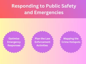
GIS-based tools enhance public safety and emergency response capabilities by integrating spatial data with incident management systems. GIS companies enable authorities to:
- Optimizing the emergency responses
- Planning out the law enforcement-related activities
- Mapping all the crime hotspots
If there is a natural disaster, the GIS companies in India will use the incident command system in disaster management to coordinate rescue efforts, resource allocation, and damage assessment. This will lead to an efficient and instant response, aid recovery, and reduce loss.
Economic Developments
Through a detailed spatial analysis, companies can use GIS technology to find the best opportunities for economic development. Cities can pull in businesses by displaying their market potential, demographic trends, and real estate.
GIS will also help in supporting tourism as it can point out all the amenities and attractions in a city, which will contribute towards economic growth.
Transportation and Traffic
For all the smart cities, managing traffic is highly essential. GIS companies can use the GIS system to analyze traffic patterns, manage public transportation systems, and optimize routes.
These companies will also be able to integrate the GIS devices into the GIS platforms to deliver live updates on the traffic. This will enhance mobility and alleviate congestion.
Urban Development and Planning
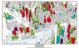
With the help of GIS technology, companies can help with the interpretation of spatial data, analysis, and visualization. All these things are compulsory for urban planning.
Many planners utilize this particular technology to map the present infrastructure, model upcoming developments, and assess land usage.
By doing so, planners can make correct decisions on environmental management, public-related services, and zoning the transportation networks.
Understanding the Benefits of GIS Technology
The GIS technology is equipped with countless advantages, and the table below will give you detailed information on them.
| GIS Technology Benefits | The Description |
| Disaster Management | Emergency planning and risk assessment can improve response and preparedness during natural disasters. |
| Market Analysis | Analysis of spatial data and demographics will help support the marketing approaches and business locations. |
| Visualization | Offering a visual representation with maps can improve communication and understanding. |
| Agriculture | Provides support for crop management and accurate farming and helps monitor all agricultural activities. |
| Education | Helps in offering various tools for teaching environmental science, geography and many other fields. |
| Crime Mapping | Aids in analyzing all the crime patterns to improve public safety and law enforcement. |
| Utility Management | Helps in managing the infrastructure with numerous utilities like gas, electricity and water. |
| Historical Preservation | Enables the management and preservation of all the cultural heritages and historical locations. |
Final Thoughts
The GIS companies in India play a completely multifaceted part In the smart city industries. The GIS-based devices and tools that they have in store are compulsory for creating livable, sustainable, and efficient cities. This will make the GIS companies indispensable partners in the smart city environment.
Furthermore, at SCS Tech India PVT Ltd, we offer GIS-based solutions and services across the globe. Leveraging avant-garde technology, our offerings include enterprise solutions, cloud computing, eGoverance, blockchain solutions, IT infrastructure, digital transformation, and utility and energy solutions.
Our innovative services and solutions establish a robust digital foundation in today’s transformed world. Take advantage of our services across diverse sectors, including agriculture, education, finance, and healthcare. Get in touch with us to learn more!