Tag: #india

  • Understanding Big Data in GIS Applications: How It Shapes Our World

    Understanding Big Data in GIS Applications: How It Shapes Our World

    What if we could predict traffic jams, track pollution spread, and optimize city planning—all in real-time? Significant data infusion into geographical information systems (GIS) and advanced GIS services has made all these possible. The geospatial data analytics market has been growing globally, valued at $88.3 billion since 2020. This growth shows how organizations are using big data in GIS applications to make smarter decision

    In this blog, let’s discuss how Big Data is revolutionizing GIS applications, from cloud-based platforms to drone mapping services in India, and how GIS and IoT solve real-world problems.

    What Is GIS and Why Big Data Matters?

    GIS is a tool that enables us to visualize, analyze, and interpret spatial data—that is, data associated with specific locations on Earth. Think of it as a map with multiple layers of information, showing everything from land use to population density. Paired with Big Data—massive datasets with variety and speed—GIS transforms into a powerhouse for understanding complex relationships.

    For instance:

    • Big Data from IoT Sensors: The sensors in smart cities monitor real-time air quality, traffic, and temperature and feed into GIS systems with updated knowledge.
    • Crowdsourced Data: Platforms like OpenStreetMap enable individuals to share local knowledge, which feeds into maps with detailed information and accuracy.

    How Big Data Empowers GIS Applications

    Big data in GIS applications transforming mapping
    Big data in GIS applications transforming mapping

    Big Data empowers GIS in ways that methods of the past could not. Here’s how:

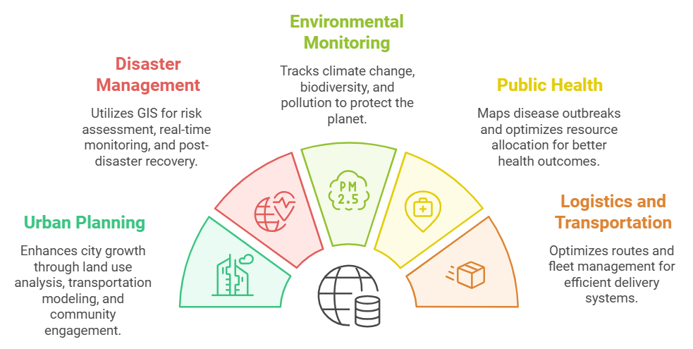
    1. Urban Planning Made Smarter

    • Land Use Analysis: Satellite imagery coupled with socioeconomic data helps planners track changes in land use over time. This ensures cities grow sustainably.
    • Transportation Modeling: GPS data from vehicles helps optimize routes and reduce congestion. For example, public transport systems can change routes dynamically based on traffic patterns.
    • Community Engagement: Interactive maps allow citizens to visualize and comment on urban projects, fostering transparency.

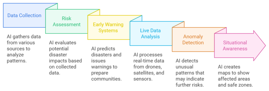
    2. Disaster Management: Saving Lives

    • Risk Assessment: GIS analyzes weather patterns and historical data to pinpoint areas at risk of flooding or earthquakes.
    • Real-Time Monitoring: During disasters, data from IoT devices and social media feeds helps responders understand the situation instantly.
    • Post-Disaster Recovery: Aerial drone images provide clear visuals of affected areas, speeding up relief efforts.

    3. Environmental Monitoring: Protecting the Planet

    • Climate Studies: Long-term satellite data reveals how vegetation and glaciers change over time due to global warming.
    • Biodiversity Conservation: GIS maps endangered species’ habitats, helping identify critical areas that require conservation.
    • Pollution Tracking: Air quality sensors feed into GIS systems that track how pollution spreads throughout cities, helping policymakers take action.

    4. Public Health: Monitoring and Controlling Diseases

    • Outbreak Mapping: GIS helped to visualize the case patterns in the COVID-19 pandemic. It allowed authorities to focus their resources on high-risk areas.
    • Resource Allocation: Through GIS, hospitals and clinics analyze population density in the area to provide better services.

    5. Logistics and Transportation: Moving Smarter

    • Route Optimization: Companies like UPS apply GIS to analyze traffic and deliver packages faster.
    • Fleet Management: GPS-enabled trucks feed the GIS system with location data, thus enabling real-time tracking and efficient route planning.

    Cutting-edge technologies in GIS

    GIS is growing with exciting technologies that make it even more powerful:

    Cloud-Based GIS Platforms

    Cloud technology has revolutionized GIS, making it accessible and scalable:

    • Real-Time Data Processing: Platforms like Esri’s ArcGIS Online allow seamless spatial data sharing and processing.
    • Collaboration: Teams can work on the same map from anywhere, fostering innovation and efficiency.
    • Cost-Effectiveness: Cloud-based GIS eliminates the need for expensive hardware, making it ideal for organizations of all sizes.

    Drone Mapping Services in India

    India’s rapid adoption of drone technology is transforming GIS applications:

    • Precision Mapping: Drones take high-resolution images for infrastructure projects and agriculture.
    • Disaster Response: Drones provide critical aerial visuals to aid recovery after natural disasters.
    • Urban Planning: Cities like Bangalore use drone data to plan better transportation and housing.

    GIS and IoT Applications

    IoT devices, from weather stations to traffic sensors, feed GIS systems with valuable real-time data:

    • Smart Cities: Sensors monitor everything from electricity usage to water flow, making for more innovative and sustainable urban environments.
    • Agriculture: IoT-enabled sensors monitor soil moisture and crop health for farmers to optimize yields.
    • Environmental Monitoring: Networks of IoT devices measure air and water quality, feeding GIS with critical ecological data.

    Challenges in Integrating Big Data with GIS

    With all its benefits, big data in GIS applications is fraught with its challenges:

    • Data Quality: Inaccurate or out-of-date data can result in poor decisions. Validation is a continuous process.
    • Technical Expertise: Professionals must be trained in geospatial analysis and data science, which requires extensive training.
    • Privacy Issues: The use of personal location data raises ethical issues. Clear policies and transparency are critical to building public trust.

    Future Directions for Big Data in GIS

    The integration of emerging technologies will redefine GIS:

    • AI and Machine Learning: These technologies will further power predictive analytics in GIS, automating pattern recognition and forecasting.
    • Cloud-Based GIS Platforms: Cloud storage will make smaller organizations more accessible and collaborative.
    • Drone Mapping Services: Drones equipped with GIS technology will continue to provide high-resolution data for agriculture, urban planning, and disaster response in India.
    • GIS and IoT Applications: IoT networks expand the scope of real-time monitoring from innovative city management to wildlife conservation.

    Conclusion

    The intersection of big data in GIS applications has opened doors for new understanding and solutions to complex geographic problems. From improving urban planning to enhancing disaster response and protecting the environment, GIS in India is playing a vital role in shaping a more innovative and sustainable world.

    As cloud-based GIS platforms and drone mapping services in India continue to evolve, companies like SCS Tech play an important role in driving innovation and delivering robust solutions. By addressing challenges such as data quality and privacy, we can utilize the full potential of Big Data in GIS applications, creating solutions that truly make a difference.


  • How Artificial Intelligence in Disaster Management Software Is Saving Lives?

    How Artificial Intelligence in Disaster Management Software Is Saving Lives?

    What if we could turn chaos into clarity during disasters? Since 1990, floods have caused $50 billion in damages and impacted millions in India. Knowing about a disaster before it strikes could give communities time to prepare and respond effectively. That’s where Artificial Intelligence is turning this possibility into a reality. From issuing early warnings for hurricanes to guiding rescue operations during floods, AI is revolutionizing disaster management.

    In this blog, let’s explore how AI in disaster management software transforms predictions, responses, and recovery efforts to save lives.

    How Artificial Intelligence in Disaster Management Software Is Saving Lives?

    AI in disaster management software enhancing life-saving efforts
    AI in disaster management software enhancing life-saving efforts

    Artificial Intelligence (AI) revolutionizes disaster management by permitting more accurate predictions, speedy responses, and efficient recoveries. AI enables advanced algorithms, and real-time data is fed to disaster management software to soften the impact of natural and artificial disasters.

    1. Disaster forecasting through AI

    AI has come as one of the significant transformations that AI has undergone to improve disaster management systems. Through analyzing vast amounts of data and finding patterns, the chances of predicting and, thus, preparing for any disaster are primarily enhanced.

    Data Collection by AI

    AI collects data from different sources, and this includes:

    • Weather data, which can track storms, hurricanes, and cyclones
    • A seismic activity record is used to identify the initial seismic signals of an earthquake.
    • Historical data to identify trends of disaster recurrences in certain areas.

    This integrated analysis helps accurately predict when and where disasters might occur. For instance, AI can scan satellite images to monitor ocean temperatures and predict the cyclone’s formation.

    Risk Assessment

    AI evaluates the potential damage caused by disasters by assessing:

    • Population density: Determining areas where the disaster would impact the most people.
    • Infrastructure weaknesses: This highlights the weak points such as bridges, dams, or flood-prone neighborhoods.
    • Environmental factors: These are natural features such as forests or water bodies that may affect the intensity of disasters.

    This helps governments and agencies to plan better and provide more resources to high-risk areas.

    Early Warning Systems

    Machine learning models are trained on historical data, predicting disaster patterns and providing early warnings. These warnings:

    • Give communities enough time to evacuate or prepare.
    • Allowing authorities to preposition emergency supplies, including food, water, and medical kits.

    For instance, AI-based flood prediction systems use rainfall, river levels, and soil saturation data to predict floods days ahead of time. This helps save lives and reduce property damage.

    2. Real-Time Monitoring of Disasters

    When disasters occur, the difference between life and death can be a matter of having accurate information in real-time. AI shines in monitoring unfolding events and guiding responders in real-time.

    Live Data Analysis

    AI processes live feeds from sources like:

    • Drones: Taking aerial views of disaster-stricken areas to identify damage and locate stranded individuals.
    • Satellites: Offering large-scale images to track the spread of disasters such as wildfires or floods.
    • IoT Sensors: Track water levels, air quality, and structural strength in disaster areas.

    Processing this information in real-time, AI provides actionable insight to the emergency teams to determine the nature of the situation and plan for it.

    Anomaly Detection

    AI constantly monitors the critical parameters and detects anomalies that might lead to further deterioration. Such anomalies could be:

    • Rising water levels above flood safety levels.
    • Rapidly rising temperatures in a forested area potentially indicate wildfires.
    • Gas leaks in earthquake-damaged industrial areas.

    The detection alerts the responders, who can take prompt action before further damage is done.

    Situational Awareness

    AI-based GIS creates comprehensive maps that outline the following:

    • Storm-inundated areas
    • Affected areas due to wildfires and landslides
    • Safe zones for evacuation or relief operations.

    These maps enable better resource allocation so that aid would first reach the most vulnerable areas. For instance, AI-enhanced drones can identify stranded victims and direct rescue boats to that area during floods.

    3. Response Automation

    With AI able to automate critical tasks in the response function, emergency operations become swift and efficient with fewer chances of delay and error.

    Optimized Dispatch

    AI orders distress calls according to priority and determines their urgency and location. It may be demonstrated as below:

    • Calls from severely affected areas will be prioritized over other less urgent requests.
    • AI systems scan traffic conditions to route emergency vehicles to destinations as quickly as possible.

    This ensures that ambulances, fire trucks, and rescue teams reach the victims in need much faster, even in the most chaotic environment.

    Traffic Management

    In evacuations, traffic congestion is one of the biggest threats to lives. AI systems scan traffic patterns in real-time and recommend:

    • Alternative routes to avoid gridlocks.
    • Safe evacuation routes for big crowds.

    AI will give the safest route to avoid danger zones during a wildfire, ensuring civilians and emergency responders stay safe.

    The Future of AI in Disaster Management Software

    The use of AI in disaster management is getting stronger with every passing day. Here’s what might be in store:

    • Improved Predictive Models: AI will predict disasters even more accurately with better algorithms and data.
    • Real-Time Adaptation: AI systems would change responses dynamically in response to real-time updates to be efficient.
    • Collaboration Tools: Future AI systems enable easy data exchange among government agencies, NGOs, and AI technology companies.
    • Integration with IoT: AI-based incident management systems work with IoT devices like smart sensors to monitor critical parameters like water level and air quality in real-time.

    For instance, in flood-prone areas, AI, in conjunction with IoT sensors, can facilitate real-time updates that inform people in advance to evacuate in time.

    Conclusion

    Artificial Intelligence changes the face of disaster management software by saving lives through accurate predictions, swift reactions, and intelligent resource allocation. AI ensures people obtain information immediately by sending early warnings and real-time updates.

    In countries with frequent natural disasters, we must use AI-driven tools to reduce damage and protect communities. These tools do not only help us prepare but also respond better during emergencies. Companies like SCS Tech drive these innovations to build safer and more resilient communities and tap into the power of technology to save lives.


  • How E-Governance Solutions Are Enhancing Citizen Participation?

    How E-Governance Solutions Are Enhancing Citizen Participation?

    Have you noticed how technology changes how governments engage with citizens? E-governance solutions are no longer a buzzword but a movement rewriting the governance rules. From speeding up social benefit transfers, innovations such as DBT systems have sparked a 192% surge in efficiency. Such advancements make governance more innovative, inclusive, and genuinely citizen-centric.

    In this blog, let’s explore how e-governance solutions, powered by advancements in AI and robust IT infrastructure, are transforming governance. These solutions incorporate active citizen participation in administration, making public services more responsive.

    How E-Governance Solutions Are Enhancing Citizen Participation?

    E-Governance boosting citizen participation
    E-Governance boosting citizen participation

    1. Digital Platform for Communication

    One of the cornerstones of e-governance is utilizing a digital platform to bring governance closer to citizens. There are real-time engagements such that citizens are constantly and regularly informed and involved with the government:

    • Web Portals and Mobile Apps: These digital gateways provide instant access to services like bill payments, license applications, and complaint registrations. Citizens do not have to visit government offices to carry out these tasks, saving them time and effort. With mobile apps, users are provided with user-friendly interfaces through which they can register complaints, access public schemes, and get updates.
    • Social Media: It is the platform through which two-way communication takes place. Platforms include Twitter, Facebook, and Instagram. Governments can inform citizens about policies, events, and public initiatives at a very fast pace, and the citizens can voice their concerns and give feedback. Through social media, governments can keep track of public opinion and respond to concerns immediately.

    These digital platforms make interaction easier and make governance more accessible and inclusive. They bridge the gap between government agencies and citizens, ensuring that everyone, regardless of location, can stay connected.

    2. E-Participation Tools

    E-governance goes beyond one-way communication by actively involving citizens in decision-making through participatory tools.

    • Online Surveys and Polls: Governments conduct surveys to gather public opinions on new policies, projects, or initiatives. This direct feedback allows decision-makers to align policies with citizen needs and preferences. For example, before launching a new law, authorities can gauge its acceptance through online polls.
    • Discussion Forums: Structured forums provide avenues for citizens to discuss and deliberate on policy issues. Such avenues allow informed participation, so that people may share their ideas, develop solutions collectively, and input into shaping community projects.
    • Crowdsourcing Programs: The government invites citizens to submit innovative ideas or solutions for public challenges. This makes them feel owned and included. For instance, citizens can suggest improvements in infrastructure, education, or health systems through specific crowdsourcing platforms.

    These tools empower citizens to take an active role in governance, ensuring that policies reflect diverse voices and community needs.

    3. Data Transparency and Accessibility

    Building Trust is founded on transparency and e-governance creates solutions for providing the public sector operations much more transparent and accountable.

    • Open Data Portals: This allows citizens to explore the available data regarding budgets, projects, and expenses. Analyzing this information can help explain to people how funds for public services are allocated and utilized, holding authorities accountable.
    • Real-Time Tracking Systems: These allow citizens to keep track of how their applications, complaints, or government services are being carried out. A citizen could apply for welfare benefits or a building permit – the status could be kept online, eliminating frustration or uncertainty.

    Transparency through such tools will not only create trust but also enhance citizens’ ability to be more actively involved in governance processes. People’s participation is meaningful when they can see the processes of decision-making as well as resource allocation.

    How E-Governance Solutions for Improved Public Sector Efficiency?

    The new solutions for e-governance redefine the delivery of services within the public sector, relying on Information Technology (IT), then Information and Communication Technologies (ICTs), and web-based platforms to facilitate effective, transparent, and accessible governance. Whether it is health or transportation, urban development, or utilities, these new solutions are changing the experience of governance for citizens.

    Integrated Services through Centralized Systems

    One of the key features of e-governance is that it combines various government services on a single platform. Such centralized systems allow for:

    • Streamlined Service Delivery: Citizens can file taxes, apply for permits, and enroll in benefits from a single portal.
    • Improved Interdepartmental Coordination: Data sharing across departments results in faster responses and reduced redundancy.
    • User-Centric Design: Easy-to-use interfaces make it easier for people to find and use services.

    For instance, an integrated platform may offer the facility to pay property tax, lodge a complaint, and obtain a driving license in one place.

    Automated Document Processes

    The olden days of paperwork, along with electronic documents and workflow management, are long gone. Such software programs automate the document handling and approval process, and therefore lead to the following:

    • Quick Delivery of Services: Service delivery happens fast without being hindered by the time-consuming nature of manual processes.
    • Less Human Errors: Automated workflows help minimize human errors.
    • More Accurate Record Keeping: Digital records promote more accountability and easy accessibility for later use.

    These automations mean real-time benefits to citizens in terms of waiting time to receive permits or certification, for example.

    Safe and Smart City Solutions

    Governments are using the IoT (Internet of Things) and AI to create better cities. These solutions benefit by:

    • Optimized Resource Allocation: Smart sensors monitor traffic, energy use, and safety metrics in real-time.
    • Proactive Services: AI-powered analytics predict service demands, such as waste collection schedules or public transport requirements.
    • Improved Safety: IoT-enabled surveillance systems and emergency response tools create safer communities.

    For instance, smart traffic management systems can reduce congestion while improving road safety for citizens.

    Conclusion

    E-governance solutions change governance by making the processes more transparent, effective, and participatory. They can enhance service delivery and citizen involvement by incorporating AI technologies into IT infrastructure solutions. Then, problems like the digital divide and data privacy exist for these solutions to be fully exploited.

    E-government, therefore, helps governments achieve a strong democracy, build up trust, and empower their citizens to take an active role in shaping their surroundings. The future of governance is easy: inclusivity, adaptability, and true people-serving technology solutions. This change provides a backdrop for an enabling force like SCS Tech, offering cutting-edge IT infrastructure solutions that make this novel development possible.

  • Why Is Incident Management Software Vital for Homeland Security and Defence Operations?

    Why Is Incident Management Software Vital for Homeland Security and Defence Operations?

    Are you aware that India ranks as the world’s second most flood-affected country?

    Facing an average of 17 floods each year, these flood events annually affect about 345 million people every year. With these frequent natural disasters, along with threats like terrorism and cyberattacks, India faces constant challenges. Therefore, now more than ever it is crucial to protect people and resources.

    To tackle this, having an effective incident management software (IMS) system is very important. It helps teams coordinate effectively and plan ahead, ensuring rapid action in critical situations.

    So how exactly does incident management software support homeland security and defense operations in managing these complex crises?

    Why Is Incident Management Software Vital for Homeland Security and Defence Operations?

    why incident management software for homeland security and defence?

    #1. Tackling the Complexity of Security Threats

    India’s diverse threats- from natural disasters to public health emergencies- call for special and flexible response strategies. This is where incident management software makes an all-important difference.

    • Multi-Dimensional Threat Landscape: India’s threats are multi-dimensional and heterogeneous, so different agencies are called to work together. IMS centralizes the platform for police, medical teams, fire services, and defense forces to share data and communicate closely to ensure all responders are in sync.
    • Evolving Threats: The threats are diverse and cannot be predicted. Incident management software is designed to respond to unanticipated crisis changes, whereas traditional responses are often left behind. It enables on-site changes based on fresh information, creating agility in response efforts.

    #2. Response Time Improvement

    When disasters strike, every second counts. Delayed response translates to more deaths or more significant property damage. Incident management software drastically cuts down response times by standardizing procedures for critical activities.

    • Access to Information in Real Time: IMS offers decision-makers instant information about the status of incidents, resource utilization, and current operations. With rapid access to the correct information, mobilization of resources is quicker and certainly does not result in delays that may augment the crisis condition.
    • Automated Processes: Some of the core processes in an IMS are automated, such as reporting and tracking, which eliminates more human errors and lets the information flow faster. At times of high pressure, such automation is instrumental in transmitting responses fast enough for loss of life and further damage.

    #3. Coordination between Agencies

    A coordinated response involving multiple agencies is fundamental during crisis management. Incident management software helps coordinate unified action by creating a central communication hub for all the responders.

    • Unified Communication Channels: IMS presents a common communication channel to all agencies. This saves the agency from confusion and misunderstanding, which may lead to errors in response and thus present hazards to the public.
    • Standard protocols: IMS places agencies into parallel response frameworks at the national level, similar to the National Disaster Management Act. That way, they will work from the same protocols, and accountability can be easily known and understood.

    #4. Enable Resource Management

    Resources are always scarce at any given moment of a disaster. The effectiveness of response is often related to the way resources are managed. Incident management software provides an essential function in resource allocation so that it reaches precisely where and when it is needed.

    • Resource Availability Visibility: IMS provides real-time situational awareness concerning available resources, people, equipment, and supplies. Agencies can rapidly deploy resources to the point of need.
    • Dynamic Resource Allocation: The demand for resources changes sharply in more significant incidents. IMS enables the responder to promptly make dynamic resource allocations to fulfill urgent needs.

    #5. Enabling Accountability and Transparency

    Transparency and accountability are essential for any democratic country such as India. Public trust must be there, and incident management software supports this and lays the foundation for the trust of people in crisis management by the government.

    • Detailed Documentation: IMS offers an audit trail of everything done during the incident. It is crucial for accountability, with every agency responding accountable for every piece of action.
    • Public Trust: Incident management transparency will build the trust of the public. More people will feel confident and trusting that the government can be there for them if they realize there is evidence of successful crisis management. IMS helps illustrate that it is not only responsive but prepared and organized.

    #6. Enabling Continuous Improvement

    One of the greatest strengths of incident management software lies in its support for continuous improvement. Through lessons learned from past events, the agencies improve their strategies in preparation for other challenges.

    • Data-Driven Insights: IMS collects data from each incident, based on which analysis of response effectiveness is conducted to identify what areas need improvements. The insights drawn from such data guide training programs, resource planning, and policy adjustments. The system thus becomes more resilient in the face of future challenges.
    • Adaptation to New Challenges: Constant adaptation is necessary, from the emergence of cyberattacks and climate-related disasters to others yet to emerge. Through historical data analysis, the central agencies are better placed to stay ahead of rising challenges and refine their responses based on lessons learned.

    Conclusion

    Incident management software has become essential in a world where evolving security threats and natural disasters constantly challenge a nation’s resilience. This is especially true for countries like India. Companies like SCS Tech develop the most sophisticated incident management software solutions, boosting response time and coordinating and managing resources accordingly.

    Such investment is bound to be operational and goes beyond that to enhance national resilience and public trust, equipping India’s security forces to respond to emerging challenges effectively.

  • How GIS Mapping Services is Transforming the Oil/Gas Sector?

    How GIS Mapping Services is Transforming the Oil/Gas Sector?

    Do you know the integration of GIS across various sectors, including oil and gas, is projected to grow at a CAGR of 12.5% and reach a market size of US $26.27 billion between the periods of 2024-30? With this growth, oil and gas companies are adopting GIS mapping services. GIS helps in optimizing pipeline routes and monitoring assets in real-time. It also improves safety protocols and analyzes large amounts of spatial data. This integration streamlines operations, reduces risks, and enhances decision-making.

    To know more about how GIS technology integration helps in achieving optimal results, read the blog that covers various aspects of the GIS mapping services integration with the oil and gas technology sector.

    GIS Workflow in Oil and Gas Operations

    What is the Role of GIS mapping services in the Oil and Gas Sector?

    GIS plays an important role in streamlining operations and saving costs in the oil and gas sector, we will discuss each factor in detail through the below-mentioned pointers:

    Exploration and Production (E&P)

    • This is the first stage in the oil and gas lifecycle; GIS here helps to integrate historical records, geological maps, seismic data, etc., to create effective reservoir modeling.
    • With these integrations, we identify locations for resource extraction and drilling. It helps in improving the accuracy of finding drilling locations and results in reduced exploration risks.
    • Reservoir modeling: a GIS mapping services feature helps visualize and model the size of the reservoir so accurate production estimates can be made.

    Asset Management and Infrastructure

    • Asset Management and Infrastructure in the Oil and Gas Sector with GIS is important for cost-effective infrastructure management, including storage, refineries, pipelines, rigs, etc.
    • Through spatial databases, GIS helps in asset maintenance and tracking. Operators can effectively determine on one single platform how the asset will be distributed across geographic locations, such as the exact location of pipelines, storage tanks, etc.
    • GIS technology also aids in optimized infrastructure planning by enabling optimal site selection, environmental considerations, and cost optimization. Additionally, it reduces risks through data integration from drones and satellites, allowing for in-depth inspections, particularly in offshore rigs and remote pipeline locations.

    Pipeline and Route Optimization

    • In the oil and gas sector, pipelines are the foundation for transporting crude oil, natural gas, and other petroleum products over long distances that can be challenging. Here, GIS plays a role in route optimization through planning and design, which is done by geospatial analysis of factors like terrain, land use, and environmental sensitivity. Route optimization is done for cost savings and less environmental disruption.
    • Listed below are a few important features offered by GIS for pipeline and route optimization.
      • Terrain and elevation analysis through slope stability analysis and analysis of elevation profiles
      • Integrating existing pipeline networks and faster access to maintenance facilities. Through predictive maintenance, one can perform a better assessment of temperature variations, terrain type, seismic activity, etc.
      • Enhancing risk management and safety through population density analysis, identification of high-risk zones, emergency response planning, etc.

    Field Data Collection and Remote Sensing

    • Integrating field data collection and remote sensing with GIS mapping enables remote data acquisition using satellite imagery, LiDAR, and aerial photography. This approach captures large-scale data over pipelines, refineries, and infrastructure. Additionally, UAVs equipped with GIS sensors provide in-depth data collection, enhancing overall accuracy.

    • Other key aspects include real-time field data collection through GPS integration and geotagging, environmental impact monitoring, sensitive ecosystem tracking, regulatory audits and inspections through data maps, etc.

    Seismic Data Analysis and Fault Line Mapping

    • Integrating GIS in India with seismic data analysis enhances vibrational data acquisition, and then we use geophones or hydrophone sensors to collect information on wave reflection.
    • Integration data also helps engineers analyze subsurface geological formations in 2D or 3D form.
    • GIS integrates seismic surveys, geological maps, and satellite imagery, which helps identify fault lines so that companies can make changes in drilling plans, develop stronger infrastructure, and develop safety protocols to mitigate the impact.

    Advantages of GIS mapping services in the Oil and Gas Sector

    The geographic information system helps the oil and gas sector by integrating tools that help in data management through data layering, emergency response planning, data sharing and collaboration, and more. Listed below are some key advantages:

    • Optimized Exploration and Drilling Operations
    • Supply Chain and Logistics Optimization
    • Enhanced Pipeline and Infrastructure Management
    • Sustainability through Optimized Resource Utilization
    • Reduction in Maintenance Costs
    • Enhanced Emergency Response and Incident Management
    • Enhanced Communication and Collaboration

    GIS Innovations and Trends Integrated by GIS Companies in India

    Listed below are a few upcoming GIS trends and innovations contributing to the transformation of the oil and gas industry:

    • Real-time data integration, such as satellite imagery and IoT sensors
    • AI and Machine learning for anomaly detection and optimization
    • Advanced geospatial analytics such as 3D modeling and spatial analysis
    • Blockchain for Data Security
    • Remote Sensing and UAVs through high-resolution aerial imagery and data collection
    • Enhanced reservoir modeling that helps in accurately predicting oil and gas reserves.

    Conclusion

    Integrating GIS technology in the oil and gas industry not only enhances operational efficiency but also transforms how we manage and ensure our resources and safety. By utilizing advanced spatial data analysis and innovative technologies, companies can achieve precise monitoring, proactive maintenance, and optimized resource usage. This strategic integration drives significant improvements, offering a competitive edge and unlocking new levels of operational excellence. Using these GIS capabilities could redefine your approach to industry challenges, setting the stage for future advancements and sustained success.

    If you are looking to capitalize on the benefits of GIS mapping services in the oil and gas industry solutions, then getting expert guidance from  SCS Tech India can be an optimal decision. Their solutions enhance precision, streamline management, and drive innovation, giving you a competitive edge while maximizing efficiency.


    FAQ

    • Can GIS help in predictive analytics in the oil and gas sector exploration?

    Yes, GIS technology helps in predictive analytics in the oil and gas sector exploration by integrating historical data with geospatial information, subsurface mapping, geological risk assessment, hydrocarbon movement prediction, and more.

    • Do GIS mapping services help in risk management in the oil and gas industry?

    Yes, GIS mapping services help in risk management by identifying high-risk zones, real-time monitoring of assets through drone and satellite monitoring, seismic risk prediction by spatial analysis, etc.

    • What are the innovations GIS companies in India are focusing on to transform the oil and gas sector in India?

    GIS companies in India are focusing on innovations like advanced remote sensing and satellite imagery, 3D reservoir modeling, seismic data integration, scalable cloud GIS platforms, hybrid energy systems, and more.

    • How can we use GIS technology in pipeline management in the oil and gas sector?

    GIS technology is important for pipeline management in the oil and gas sector as it helps detect leaks, corrosion, and pressure anomalies, ensure pipeline safety, reduce environmental risks, etc.

    (more…)

  • What to Look for When Choosing a GIS Mapping Service Provider

    What to Look for When Choosing a GIS Mapping Service Provider

    The GIS market is on track to hit $14.5 billion by 2025, fueled by its growing impact across sectors like transportation, space exploration, automotive design, and smart city planning. With such explosive growth, GIS is quickly becoming indispensable for industries looking to innovate and lead.

    This growth reflects that enterprises are now increasingly relying on GIS mapping services to enhance predictive modeling, optimize operations, and support strategic decision-making. As the demand for GIS solutions rises, selecting the right service provider becomes a critical focus on GIS mapping services that can offer precise geographic data to boost predictive modeling capabilities, optimize operations, and improve decision-making processes.

    Companies are focusing on GIS mapping service providers who not only offer robust systems that analyze, integrate, and display spatial or geographical data but also give tailored-based services as per the project demand to achieve business objectives. In this blog, we will focus on key factors that one should look for before selecting a GIS mapping services provider.

    Key Factors To Consider While Choosing A GIS Mapping Service Provider

    #1 Technical Expertise and Level of Qualification

    Delivering high-end GIS mapping services depends on skilled professionals who can efficiently handle GIS tools and technologies like big data handling, AI-driven geospatial analytics, etc., along with specialized projects like advanced spatial modeling. It is important to check that the service provider has a certification like GIS Professional (GISP).

    #2 Data Quality and Accuracy

    The data quality and accuracy are integral parts of GIS mapping as they impact the insights derived from spatial analysis. Poor-quality data can lead to increased GIS project costs and incorrect analysis, which can lead to wrong decisions.

    The following factors can be checked:

    • Check that the provider uses authoritative data sources and has a robust validation process, thereby maintaining quality and accuracy.
    • Look for providers offering in-depth metadata with information regarding data source, accuracy level, collection data, etc. to assess reliability.
    • Check whether the service provider is adhering to standards related to data accuracy set by various ISO or related bodies.
    • With a dynamic technological landscape, check that the provider is offering advanced data collection tools for better quality, like LiDAR, UAVs (Unmanned Aerial Vehicles), etc.

    #3 Service Offerings

    While choosing a GIS mapping service provider, it is important to explore what specialized and end-to-end services are offered and how they are aligned with your goal and can help you improve results. The key services offered by a GIS provider one can look for are given below:

    • End-to-end services, from the gathering of data to its processing, mapping, and final reporting for efficient project workflow, are the core services to be offered by GIS mapping service providers.
    • The service provider should offer integration of GIS data with other systems, such as CRM or ERP systems, for better utilization of data in enterprise operations.
    • Evaluate whether specialized services, like 3D modeling and visualization, are offered, mainly for urban planning/development and infrastructure-related projects. For projects involving customer mapping or asset management, the service provided should be able to provide geocoding and address matching.

    #4 Customer Service And Training

    The GIS mapping service provider should be able to offer the required customer service and training so that better utilization of GIS tools can be done to achieve the desired project outcomes. The key parameters to be looked at under the customer service and training component are

    • 24/7 Customer Support Service
    • Fast Response to Reduce Downtime
    • Comprehensive training programs, including workshops, webinars, etc.
    • Industry- or project-specific training
    • Training materials such as user manuals or video tutorials.
    • Effective feedback mechanism

    #5 Cost Structure

    While choosing a GIS mapping service provider, it is important to understand the different pricing models and how they align with your project and financial budget. In the chart below, different pricing models with key features and the right project alignment are mentioned.

    GIS Mapping services pricing model

    Other than the pricing models, cost transparency should be maintained by the service provider by highlighting the upfront fees and hidden costs like advanced customer support, data storage requirements, etc., so the organization can effectively manage contingency expenses.

    #6 Emerging Trends And Innovation Integration

    Staying updated with recent trends and innovations in GIS mapping that can be implemented in your enterprise and selecting the service provider as per the requirement is crucial for informed decision-making.

    Some of the latest innovations on the market are:

    • Real-time analytics
    • 3D GIS for better spatial visualization
    • Improved predictive analytics through machine learning and AI
    • Cloud-based GIS solution for scalability, better accessibility for remote teams, and flexibility
    • Geospatial Data Fusion to create comprehensive geospatial datasets by combining data from social media, satellites, and other sources.

    Conclusion

    The selection of the right GIS mapping service provider can be complex when you want to integrate specific requirements and advanced technologies.

    Evaluating the right GIS mapping service provider involves various factors, from technical qualification, customization, and integration to scalable solutions, as these factors help in making informed decisions that enhance an organization’s ability to leverage spatial information effectively.

    To ease out the process, consult experts from SCS Tech India to navigate the complexities and implement innovative approaches to optimize your spatial data management and have a competitive edge in the market by leveraging GIS technologies for your projects.

    FAQs

    1. What is the role of customer service when selecting a GIS mapping service provider?
      Customer service plays an important role when selecting a GIS mapping service provider for various factors like addressing issues promptly, offering required training, assisting in technical changes, and more to enhance the overall experience.
    2. What costs are involved in GIS mapping services?
      GIS mapping services include costs such as initial setup costs, software licenses, purchasing data, customizing the system, and fees involved in continuing support and maintenance.
    3. Are there any latest trends I should look after before choosing GIS mapping services?
      Yes, the current trends in GIS mapping services one should be aware of are real-time data processing, integration of machine learning for data analysis, 3D and VR mapping technologies, edge computing, and more.
    4. What are the core components of GIS mapping?
      The core components of GIS mapping include spatial data, hardware, GIS software, and database management. (more…)
  • The Impact of eGovernance Solutions on Government Efficiency

    The Impact of eGovernance Solutions on Government Efficiency

    Amidst the global surge of globalization, citizens worldwide are increasingly cognizant of their rights, pressing for transparency and efficiency from their governing bodies. To meet these burgeoning demands, traditional structures are no longer found ill-equipped to meet these burgeoning demands for streamlined public service delivery.

    In this dynamic landscape, the imperative for innovative models and systems like eGovernance has never been more pronounced. eGovernance solutions have fundamentally heralded a seismic shift in the efficiency and efficacy of governmental operations.

    This blog serves as a dedicated exploration into the transformative power of eGovernance solutions, illuminating how these advanced technologies redefine organizational performance, drive cost-efficiency, and ultimately shape a government sector that is not just efficient but also citizen-centric.

    Unveiling the Efficiency Powerhouse: eGovernance Solutions

    E-Governance, also called digital governance, focuses on using Information and Communication Technology to improve governmental processes, enhance transparency, and handle its operations and services. This encompasses a wide range of solutions, including:

    Online portals

    These simplified and easily accessible platforms create an opportunity for citizens to receive information and perform various tasks at any time. Whether it is getting a renewed license or applying for a permit, online portals enable citizens to do so as and when they want to do it.

    Data management systems

    Due to an intervention of an eGovernance solution, data is captured across departments to form a coherent database. This results in greater efficiency in handling requests, quick decision-making, and proper utilization of resources.

    Mobile applications

    Now that people are busier than ever, mobile apps are a useful way for citizens to interact with their government remotely. It can be very helpful for rural areas or those with little or no internet access in particular.

    Electronic Document Management (EDM)

    These are systems that help in the production, storage, and retrieval of documents. This cuts out paper-based systems, which reduces the time, money, and physical space required to store equipment.

    How eGovernance Solutions Enhance Efficiency?

    To understand it better let’s talk about India where the use of digital identification called Aadhaar has transformed the government services delivery system. Aadhaar verification has ensured that those in need of the welfare programs get the support they need through the right channels hence minimizing fraud instances and enhancing the targeting and delivery of social goods. According to estimates by the World Bank, Aadhaar saved over $1 billion of the Indian government’s expenses within a few years of its usage.

    Now let’s discuss in detail about how exactly eGovernance solutions enhance efficiency:

    Reduced Administrative Burden

    The eGovernance solutions replicate functions to reduce paperwork and manual data entry jobs. This saves considerable staff time, so they can handle many other issues and deliver better service to their customers.

    Faster Service Delivery

    By performing transactions online through different applications and portals, citizens can access the services without a problem. This has the effect of cutting the time clients spend waiting and enhancing service provision.

    Improved Decision-Making

    The experience gathered from the eGovernance systems helps governments to make decisions based on data analysis on current or real-time performance. It further helps in the efficient utilization of resources and the proper formulation of policies.

    Enhanced Transparency and Accountability

    One of the very important features of implementing eGovernance is that it provides citizens with easy access to government data and information. This also promotes honesty and efficiency in the public sector as the accountability is shifted to the citizens.

    Even though efficiency is a primary benefit, eGovernance has ripple effects. These solutions promote government-citizen interaction, cut down on government expenditure through the use of technology, and increase favorable conditions for businesses leading to an improved economy.

    The Road Ahead: Embracing the Future of Governance

    E-Governance is not a one-bullet solution; instead, it is an evolutionary model. While embracing the best practices in this field, eGovernance solutions must also adapt to the changes that accompany the progression of technology. Through incorporating innovation and encouraging learning within governmental organizations, governments need to be flexible to meet the continually demanding needs of the citizens within the digital era.

    Investing in eGovernance Solutions: A Wise Choice for a Brighter Future

    It is not only about the realization of eGovernance solutions but also about the creation of future governance landscapes. Technology, when adopted fully in the governance processes, provides a more efficient, accountable, and participative society. This, in turn, helps to strengthen the trust between the citizens and their government, which is the key to a better life and a more sustainable future.

    By investing in eGovernance solutions, governments can create a more efficient, transparent, and citizen-friendly environment.

    Contact us today to learn how SCS Tech India’s tailored solutions can enhance public sector service delivery.